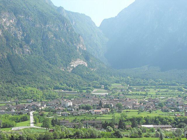
Гриньо (Grigno, Grigno)
%202018.svg)
- коммуна Италии
 Hiking in Гриньо
Grigno is a charming town located in the Trentino-Alto Adige/Südtirol region of northern Italy. Nestled in the Valsugana valley, it offers a beautiful backdrop for hiking enthusiasts who appreciate both natural beauty and cultural history. Here are some highlights and general information about hiking in and around Grigno:
Hiking Trails
-
Sentiero del Grigno: This is a scenic trail that follows the banks of the Brenta River and offers stunning views of the surrounding mountains and forests. It’s suitable for various skill levels and includes well-marked paths.
-
Cima Del Monte: For a more challenging hike, head towards Cima Del Monte. The ascent provides rewarding vistas and the chance to explore alpine flora.
-
Bivacco dell’Aquila: This trail takes you to a mountain hut that serves as a rest point for hikers. The route is moderately difficult and features picturesque landscapes and diverse wildlife.
-
Laghi di Colbricon: Located a bit further from Grigno, the lakes can be reached by a hiking trail that meanders through lush greenery and provides opportunities for photography and relaxation.
Preparation and Safety
- Maps and Information: Always carry a detailed map of the area or download an app for navigation. Local tourist offices can provide updated information on trails.
- Weather Conditions: Weather can change quickly in the mountains, so check forecasts before heading out and be prepared for different conditions.
- Gear: Bring appropriate footwear, a first aid kit, enough water, snacks, and a layered outfit for changing weather.
Local Attractions
While hiking, you can also explore local cultural sites such as:
- The Castles of Grigno: The remains of the medieval castle offer a glimpse into the region’s history.
- Traditional Cuisine: After a day of hiking, enjoy local dishes at nearby restaurants, including speck (cured ham) and various cheese specialties.
Best Time to Hike
Spring and early fall are ideal for hiking in Grigno when the weather is mild, and the scenery is lush. Summer can be quite warm, while winter trails may be suitable for snowshoeing or skiing rather than traditional hiking.
Whether you are looking for a peaceful walk or a more strenuous adventure, Grigno and the surrounding area have a range of options to suit different preferences and skill levels. Always respect nature and follow local guidelines to ensure a safe and enjoyable hiking experience.
- Страна:

- Почтовый код: 38055
- Телефонный код: 0461
- Код автомобильного номера: TN
- Координаты: 46° 1' 0" N, 11° 38' 0" E


- GPS треки (wikiloc): [Ссылка]
- Высота над уровнем моря: 263 м m
- Площадь: 46.39 кв.км
- Население: 2193
- Веб сайт: http://www.comunegrigno.it
- Википедия русская: wiki(ru)
- Википедия английская: wiki(en)
- Википедия национальная: wiki(it)
- Хранилище Wikidata: Wikidata: Q290077
- Катеория в википедии: [Ссылка]
- код Freebase: [/m/0g9z_v]
- код GeoNames: Альт: [6539503]
- код VIAF: Альт: [247902240]
- ID отношения в OpenStreetMap: [46625]
- код GND: Альт: [7756972-6]
- UN/LOCODE: [ITGGN]
- код ISTAT: 022095
- кадастровый код Италии: E178
Граничит с регионами:


Кастелло-Тезино
- коммуна Италии
Hiking in Кастелло-Тезино
Castello Tesino, located in the Trentino region of northern Italy, is a beautiful area offering a range of hiking opportunities amidst stunning natural landscapes. The region is characterized by its picturesque mountains, lush forests, and tranquil meadows, making it a perfect destination for outdoor enthusiasts....
- Страна:
- Почтовый код: 38053
- Телефонный код: 0461
- Код автомобильного номера: TN
- Координаты: 46° 4' 0" N, 11° 37' 0" E
- GPS треки (wikiloc): [Ссылка]
- Высота над уровнем моря: 905 м m
- Площадь: 112.84 кв.км
- Население: 1201
- Веб сайт: [Ссылка]


Чинте-Тезино
- коммуна Италии
Hiking in Чинте-Тезино
Cinte Tesino is a charming village located in the Trentino region of northern Italy, surrounded by the stunning landscapes of the Italian Dolomites. This area is known for its beautiful mountains, lush forests, and numerous hiking opportunities, making it a popular destination for outdoor enthusiasts....
- Страна:
- Почтовый код: 38050
- Телефонный код: 0461
- Код автомобильного номера: TN
- Координаты: 46° 3' 0" N, 11° 37' 0" E
- GPS треки (wikiloc): [Ссылка]
- Высота над уровнем моря: 851 м m
- Площадь: 30.3 кв.км
- Население: 354
- Веб сайт: [Ссылка]

Оспедалетто
- коммуна Италии
Hiking in Оспедалетто
Ospedaletto, located in the Trentino region of northern Italy, offers a beautiful backdrop for hiking enthusiasts. Nestled within the Brenta Dolomites, the area is characterized by stunning mountain scenery, lush forests, and serene landscapes, making it a great destination for both novice and experienced hikers....
- Страна:
- Почтовый код: 38050
- Телефонный код: 0461
- Код автомобильного номера: TN
- Координаты: 46° 3' 0" N, 11° 33' 0" E
- GPS треки (wikiloc): [Ссылка]
- Высота над уровнем моря: 360 м m
- Площадь: 16.75 кв.км
- Население: 803
- Веб сайт: [Ссылка]


Арсье
- коммуна Италии
Hiking in Арсье
Arsiè is a charming town located in the province of Belluno, in the Veneto region of Italy. It is situated at the foothills of the Dolomites, making it a fantastic destination for hiking enthusiasts. The surrounding landscapes are characterized by stunning mountain scenery, lush forests, and picturesque valleys....
- Страна:
- Почтовый код: 32030
- Телефонный код: 0439
- Код автомобильного номера: BL
- Координаты: 45° 59' 0" N, 11° 45' 0" E
- GPS треки (wikiloc): [Ссылка]
- Высота над уровнем моря: 315 м m
- Площадь: 64.76 кв.км
- Население: 2275
- Веб сайт: [Ссылка]
Энего
- коммуна Италии
Hiking in Энего
Enego is a charming town in the Veneto region of northern Italy, situated in the foothills of the Asiago Plateau. It offers beautiful landscapes and a variety of hiking opportunities, making it an excellent destination for outdoor enthusiasts....
- Страна:
- Почтовый код: 36052
- Телефонный код: 0424
- Код автомобильного номера: VI
- Координаты: 45° 56' 0" N, 11° 43' 0" E
- GPS треки (wikiloc): [Ссылка]
- Высота над уровнем моря: 800 м m
- Площадь: 52.61 кв.км
- Население: 1645
- Веб сайт: [Ссылка]


Азиаго
- коммуна Италии
Hiking in Азиаго
Asiago is a beautiful town located in the Veneto region of Italy, known for its stunning landscapes, rich history, and delicious cheese. The surrounding area offers numerous hiking opportunities, making it a popular destination for outdoor enthusiasts....
- Страна:
- Почтовый код: 36012
- Телефонный код: 0424
- Код автомобильного номера: VI
- Координаты: 45° 52' 0" N, 11° 31' 0" E
- GPS треки (wikiloc): [Ссылка]
- Высота над уровнем моря: 1001 м m
- Площадь: 162.95 кв.км
- Население: 6441
- Веб сайт: [Ссылка]