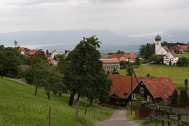
Груб (Grub, Grub)

 Hiking in Груб
Grub, located in the Appenzell Ausserrhoden region of Switzerland, is known for its stunning scenic beauty and a variety of hiking trails that cater to different skill levels. Here’s a brief overview of what you can expect when hiking in this beautiful area:
Trails and Terrain
- Diverse Hiking Trails: Grub features numerous marked hiking trails, ranging from easy walks suitable for families to more challenging routes for experienced hikers. Trails often showcase breathtaking views of the surrounding mountains, meadows, and traditional Swiss chalets.
- Elevation Changes: While many trails are accessible and relatively flat, be prepared for some elevation changes, especially if you venture onto higher paths. The region provides a mix of flat walks along the valley and steeper ascents into the foothills of the Alps.
Scenic Views
- Panoramic Landscapes: Hikers can enjoy panoramic views of the Alpstein mountain range, verdant pastures, and picturesque hills. On clear days, you might even catch sight of the distant peaks of the Swiss Alps.
- Lakes and Streams: Some trails lead you near mountain lakes or flowing streams, which are particularly beautiful in spring and summer when the wildflowers bloom.
Flora and Fauna
- Biodiversity: The Appenzell region is home to a wide range of flora and fauna. Keep an eye out for various species of wildflowers, butterflies, and possibly even chamois or ibex if you're hiking at higher elevations.
Facilities and Accessibility
- Trail Markings: The trails in Grub are well-marked, making it easy to navigate. Be sure to carry a map or use a hiking app for additional guidance.
- Starting Points: Grub is easily accessible by public transport, and there may be parking options nearby if you're driving. This accessibility allows you to explore various segments of what the region has to offer.
Tips for Hikers
- Weather Preparedness: Always check the weather forecast before heading out, as conditions can change rapidly in the mountains. Layered clothing is advisable.
- Safety First: Make sure to stay on marked trails, inform someone of your hiking plans, and carry enough water and snacks for your journey.
- Respect Nature: Follow Leave No Trace principles, respect wildlife, and enjoy the serene environment responsibly.
Conclusion
Hiking in Grub offers a fantastic experience for nature lovers and outdoor enthusiasts. Whether you're eager for a leisurely stroll or an invigorating mountain hike, the area has something to offer everyone. Enjoy your adventures in this beautiful part of Switzerland!
- Страна:

- Почтовый код: 9035
- Телефонный код: 071
- Код автомобильного номера: AR
- Координаты: 47° 26' 53" N, 9° 30' 34" E


- GPS треки (wikiloc): [Ссылка]
- Высота над уровнем моря: 986 м m
- Площадь: 4.22 кв.км
- Население: 1045
- Веб сайт: http://www.grub.ch
- Википедия русская: wiki(ru)
- Википедия английская: wiki(en)
- Википедия национальная: wiki(de)
- Хранилище Wikidata: Wikidata: Q67200
- Катеория в википедии: [Ссылка]
- код Freebase: [/m/01v6d9]
- код GeoNames: Альт: [7285994]
- ID отношения в OpenStreetMap: [1683891]
- идентификатор HDS: [1305]
- код швейцарского муниципалитета: [3031]
Граничит с регионами:

Эггерсрит
Hiking in Эггерсрит
Eggersriet is a charming little town located in the canton of St. Gallen, Switzerland, nestled amidst beautiful landscapes. Hiking in and around Eggersriet allows you to enjoy breathtaking views of the surrounding hills, forests, and rural scenery....
- Страна:
- Почтовый код: 9034
- Телефонный код: 071
- Код автомобильного номера: SG
- Координаты: 47° 26' 59" N, 9° 27' 59" E
- GPS треки (wikiloc): [Ссылка]
- Высота над уровнем моря: 817 м m
- Площадь: 8.82 кв.км
- Население: 2275
- Веб сайт: [Ссылка]


Реэтобель
Hiking in Реэтобель
Rehetobel is a scenic area located in the canton of Appenzell in Switzerland, known for its picturesque landscapes and hiking opportunities. Here are some highlights and tips for hiking in Rehetobel:...
- Страна:
- Почтовый код: 9038
- Телефонный код: 071
- Код автомобильного номера: AR
- Координаты: 47° 25' 40" N, 9° 28' 54" E
- GPS треки (wikiloc): [Ссылка]
- Высота над уровнем моря: 940 м m
- Площадь: 6.72 кв.км
- Население: 1750
- Веб сайт: [Ссылка]


Хайден
- коммуна в кантоне Аппенцелль-Ауссерроден (Швейцария)
Hiking in Хайден
Heiden is a picturesque village located in the Appenzell region of Switzerland, known for its stunning views of Lake Constance and its surrounding mountains. Hiking in and around Heiden offers a range of scenic trails suitable for different skill levels, making it a delightful destination for outdoor enthusiasts. Here are some highlights:...
- Страна:
- Почтовый код: 9410
- Телефонный код: 071
- Код автомобильного номера: AR
- Координаты: 47° 26' 28" N, 9° 31' 52" E
- GPS треки (wikiloc): [Ссылка]
- Высота над уровнем моря: 802 м m
- Площадь: 7.5 кв.км
- Население: 4192
- Веб сайт: [Ссылка]