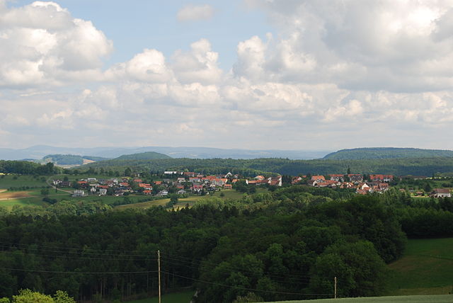
Хефельфинген (Häfelfingen, Häfelfingen)

 Hiking in Хефельфинген
Häfelfingen is a charming village located in the Basel-Landschaft region of Switzerland, offering beautiful landscapes and opportunities for hiking enthusiasts. The area is characterized by its rolling hills, picturesque vineyards, and stunning views of the surrounding Swiss countryside. Here are some key points about hiking in and around Häfelfingen:
Hiking Trails
-
Local Trails: Häfelfingen has several well-marked trails suitable for various skill levels. You can find routes that are perfect for leisurely walks as well as more challenging hikes. The paths often take you through vineyards and forests, offering a serene experience.
-
Scenic Views: Many trails provide excellent vantage points from which to enjoy panoramic views of the Jura mountains and the Rhine Valley. Be sure to bring your camera!
-
Connecting Routes: Häfelfingen is well connected to a larger network of hiking trails in the region. You can easily venture into the nearby towns of Liestal, Riehen, or even further into the Jura mountains for more extensive hiking experiences.
Best Times to Hike
- Spring and Fall: These seasons are ideal for hiking, with pleasant temperatures and vibrant scenery as flowers bloom or leaves change color.
- Summer: While summer hikes can be enjoyable, be prepared for warmer temperatures. Early morning hikes can help you avoid the midday heat.
Facilities
- Waymarking: The hiking trails are generally well-signposted, making navigation easier. However, carrying a map or a GPS device is always wise, particularly if you're exploring less-traveled paths.
- Rest Areas: Look for rest areas along the trails where you can take a break and enjoy a packed lunch with a view.
Tips for Hiking in Häfelfingen
- Footwear: Wear sturdy hiking boots that provide good ankle support, as some trails may be uneven or rocky.
- Weather: Check the weather forecast before heading out, as conditions can change rapidly in the mountainous areas.
- Hydration and Snacks: Carry enough water and snacks to keep your energy levels up throughout your hike.
- Respect Nature: Follow the Leave No Trace principles to protect the environment and wildlife.
Local Attractions
- After your hike, you might want to explore the village of Häfelfingen itself, with its charming architecture and local culture. You can also visit nearby wine producers for tastings, particularly if you enjoy local Swiss wines.
Whether you're a seasoned hiker or a beginner looking to explore the beauty of Switzerland, Häfelfingen offers a delightful outdoor experience. Enjoy your hiking adventures!
- Страна:

- Почтовый код: 4445
- Телефонный код: 062
- Код автомобильного номера: BL
- Координаты: 47° 24' 47" N, 7° 52' 13" E


- GPS треки (wikiloc): [Ссылка]
- Высота над уровнем моря: 599 м m
- Площадь: 3.96 кв.км
- Население: 271
- Веб сайт: http://www.haefelfingen.ch
- Википедия русская: wiki(ru)
- Википедия английская: wiki(en)
- Википедия национальная: wiki(de)
- Хранилище Wikidata: Wikidata: Q65120
- Катеория в википедии: [Ссылка]
- код Freebase: [/m/0g8168]
- код GeoNames: Альт: [7286018]
- код VIAF: Альт: [133544837]
- ID отношения в OpenStreetMap: [1683658]
- идентификатор HDS: [1223]
- код швейцарского муниципалитета: [2847]
Граничит с регионами:


Лойфельфинген
Hiking in Лойфельфинген
Läufelfingen is a charming village located in the district of Liestal in the canton of Basel-Landschaft, Switzerland. It offers a range of hiking opportunities that showcase the stunning Swiss landscape, including rolling hills, forested areas, and scenic viewpoints. Here’s what you can expect when hiking in and around Läufelfingen:...
- Страна:
- Почтовый код: 4448
- Телефонный код: 062
- Код автомобильного номера: BL
- Координаты: 47° 23' 37" N, 7° 51' 21" E
- GPS треки (wikiloc): [Ссылка]
- Высота над уровнем моря: 556 м m
- Площадь: 8.15 кв.км
- Население: 1321
- Веб сайт: [Ссылка]


Цеглинген
Hiking in Цеглинген
Zeglingen is a picturesque village located in the municipality of Sissach in Switzerland, surrounded by stunning natural landscapes, making it a great spot for hiking enthusiasts. Here are some key highlights about hiking in the Zeglingen area:...
- Страна:
- Почтовый код: 4495
- Телефонный код: 061
- Код автомобильного номера: BL
- Координаты: 47° 24' 44" N, 7° 54' 44" E
- GPS треки (wikiloc): [Ссылка]
- Высота над уровнем моря: 596 м m
- Площадь: 7.91 кв.км
- Население: 489
- Веб сайт: [Ссылка]
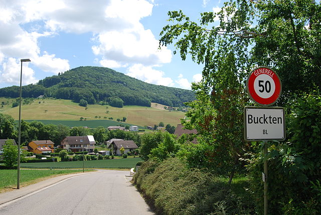

Буктен
Hiking in Буктен
Buckten is a charming village located in the canton of Aargau, Switzerland, surrounded by stunning natural scenery that makes it a great destination for hiking enthusiasts. The region offers a variety of hiking trails suitable for different levels of experience. Here's what you might want to know about hiking in and around Buckten:...
- Страна:
- Почтовый код: 4446
- Телефонный код: 062
- Код автомобильного номера: BL
- Координаты: 47° 24' 43" N, 7° 50' 48" E
- GPS треки (wikiloc): [Ссылка]
- Высота над уровнем моря: 516 м m
- Площадь: 1.99 кв.км
- Население: 694
- Веб сайт: [Ссылка]

Рюненберг
Hiking in Рюненберг
Rünenberg, located in the canton of Baselland in Switzerland, is an excellent area for hiking enthusiasts. The region offers picturesque landscapes, charming farms, and views of the rolling hills typical of the Swiss countryside. Here are some highlights to consider when hiking in Rünenberg:...
- Страна:
- Почтовый код: 4497
- Телефонный код: 061
- Код автомобильного номера: BL
- Координаты: 47° 25' 55" N, 7° 52' 49" E
- GPS треки (wikiloc): [Ссылка]
- Высота над уровнем моря: 585 м m
- Площадь: 4.98 кв.км
- Население: 777
- Веб сайт: [Ссылка]


Рюмлинген
Hiking in Рюмлинген
Rümlingen is a small village in Switzerland known for its picturesque landscapes and access to nature, making it a great spot for hiking enthusiasts. The region is characterized by rolling hills, lush meadows, and peaceful forests, providing a variety of trails suitable for different skill levels....
- Страна:
- Почтовый код: 4444
- Телефонный код: 062
- Код автомобильного номера: BL
- Координаты: 47° 25' 31" N, 7° 50' 59" E
- GPS треки (wikiloc): [Ссылка]
- Высота над уровнем моря: 459 м m
- Площадь: 2.28 кв.км
- Население: 390
- Веб сайт: [Ссылка]