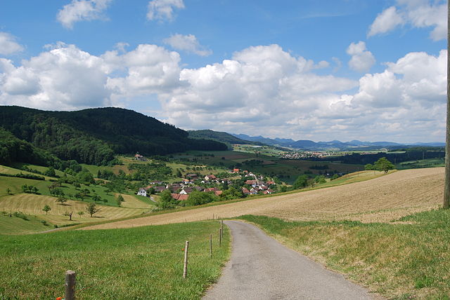
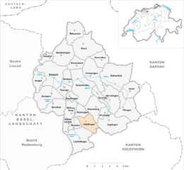
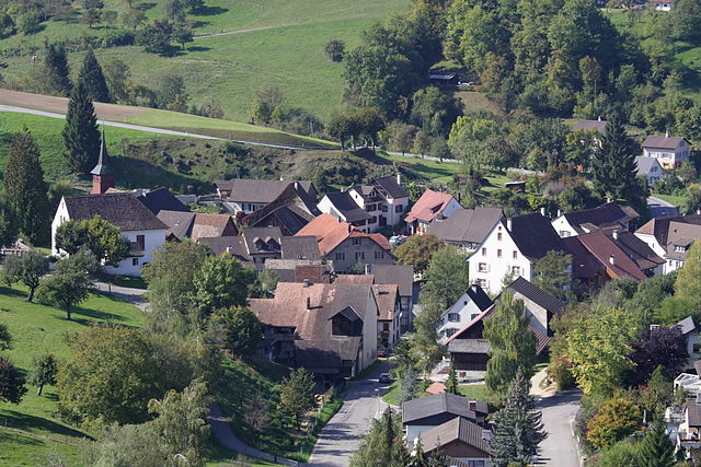
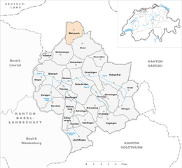
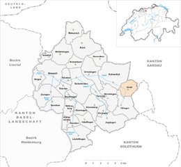
Зиссах (Sissach District, Bezirk Sissach)

 Hiking in Зиссах
Sissach District, located in the Basel-Landschaft region of Switzerland, offers beautiful hiking opportunities that showcase the region's natural beauty and diverse landscapes. Here are some highlights of hiking in this area:
Trails and Routes
-
Birs Valley Trail: This picturesque trail follows the Birs River, offering stunning views of the surrounding hills and forests. It's a relatively easy hike, making it suitable for families and beginners.
-
Sissach Ridge: For more experienced hikers, the ridge trails provide breathtaking panoramas of the Swiss Jura mountains. The trails can be steep and challenging, rewarding hikers with scenic vistas at higher elevations.
-
Historical Trails: Some trails in the district are connected to historical sites, including old farmhouses and traditional Swiss architecture. These routes often provide insight into the region's history and culture.
Nature and Wildlife
The Sissach District is rich in biodiversity. Hikers may encounter various flora, including wildflowers and lush forests, as well as fauna such as deer, foxes, and numerous bird species. Wildlife enthusiasts may particularly enjoy dawn and dusk hikes when animal activity is at its peak.
Tips for Hiking
- Maps and Signage: Many trails are well-marked, but having a hiking map or using a GPS app is advisable, especially for less-traveled paths.
- Weather Conditions: The weather can change quickly in the region, so it's important to check the forecast and dress in layers.
- Proper Gear: Sturdy hiking shoes are essential. Additionally, consider bringing trekking poles for stability on uneven terrains.
Local Amenities
Sissach has several quaint villages with local eateries and accommodations, providing nice stops for a meal or rest after a day of hiking. The local cuisine often reflects Swiss traditions, showcasing regional ingredients.
Accessibility
Most trails in the district are accessible from nearby public transport options, making it easy for visitors to explore without the need for a car.
Overall, hiking in Sissach District is a wonderful way to experience Switzerland's enchanting landscapes, delve into its rich natural and cultural heritage, and enjoy outdoor activities. Whether you're a seasoned hiker or just starting, there's something for everyone here.
- Страна:

- Столица: Зиссах
- Код автомобильного номера: BL
- Координаты: 46° 4' 0" N, 7° 3' 0" E


- GPS треки (wikiloc): [Ссылка]
- Высота над уровнем моря: 467 м m
- Площадь: 138.29 кв.км
- Википедия русская: wiki(ru)
- Википедия английская: wiki(en)
- Википедия национальная: wiki(de)
- Хранилище Wikidata: Wikidata: Q660249
- Катеория в википедии: [Ссылка]
- код Freebase: [/m/026trl7]
- код GeoNames: Альт: [6458823]
- код VIAF: Альт: [249395518]
- идентификатор местоположения ArchINFORM: [5900]
Включает регионы:


Лойфельфинген
Hiking in Лойфельфинген
Läufelfingen is a charming village located in the district of Liestal in the canton of Basel-Landschaft, Switzerland. It offers a range of hiking opportunities that showcase the stunning Swiss landscape, including rolling hills, forested areas, and scenic viewpoints. Here’s what you can expect when hiking in and around Läufelfingen:...
- Страна:
- Почтовый код: 4448
- Телефонный код: 062
- Код автомобильного номера: BL
- Координаты: 47° 23' 37" N, 7° 51' 21" E
- GPS треки (wikiloc): [Ссылка]
- Высота над уровнем моря: 556 м m
- Площадь: 8.15 кв.км
- Население: 1321
- Веб сайт: [Ссылка]
Хефельфинген
Hiking in Хефельфинген
Häfelfingen is a charming village located in the Basel-Landschaft region of Switzerland, offering beautiful landscapes and opportunities for hiking enthusiasts. The area is characterized by its rolling hills, picturesque vineyards, and stunning views of the surrounding Swiss countryside. Here are some key points about hiking in and around Häfelfingen:...
- Страна:
- Почтовый код: 4445
- Телефонный код: 062
- Код автомобильного номера: BL
- Координаты: 47° 24' 47" N, 7° 52' 13" E
- GPS треки (wikiloc): [Ссылка]
- Высота над уровнем моря: 599 м m
- Площадь: 3.96 кв.км
- Население: 271
- Веб сайт: [Ссылка]


Цеглинген
Hiking in Цеглинген
Zeglingen is a picturesque village located in the municipality of Sissach in Switzerland, surrounded by stunning natural landscapes, making it a great spot for hiking enthusiasts. Here are some key highlights about hiking in the Zeglingen area:...
- Страна:
- Почтовый код: 4495
- Телефонный код: 061
- Код автомобильного номера: BL
- Координаты: 47° 24' 44" N, 7° 54' 44" E
- GPS треки (wikiloc): [Ссылка]
- Высота над уровнем моря: 596 м m
- Площадь: 7.91 кв.км
- Население: 489
- Веб сайт: [Ссылка]


Кенеркинден
Hiking in Кенеркинден
Känerkinden is a beautiful area located in the Swiss region of Aargau, offering a variety of hiking opportunities that showcase the stunning natural landscapes, lush forests, and panoramic views. The region is characterized by rolling hills and picturesque valleys, making it suitable for both novice and experienced hikers....
- Страна:
- Почтовый код: 4447
- Телефонный код: 062
- Код автомобильного номера: BL
- Координаты: 47° 24' 44" N, 7° 50' 14" E
- GPS треки (wikiloc): [Ссылка]
- Высота над уровнем моря: 576 м m
- Площадь: 1.48 кв.км
- Население: 530
- Веб сайт: [Ссылка]

Гельтеркинден
Hiking in Гельтеркинден
Gelterkinden, located in the canton of Basel-Landschaft in Switzerland, is an excellent destination for hiking enthusiasts. The region is characterized by picturesque landscapes, diverse terrain, and a mix of forests, hills, and meadows. Here are some key points to consider when hiking in Gelterkinden:...
- Страна:
- Почтовый код: 4460
- Телефонный код: 061
- Код автомобильного номера: BL
- Координаты: 47° 27' 55" N, 7° 51' 10" E
- GPS треки (wikiloc): [Ссылка]
- Высота над уровнем моря: 458 м m
- Площадь: 9.79 кв.км
- Население: 6095
- Веб сайт: [Ссылка]


Ольтинген
Hiking in Ольтинген
Oltingen is a charming village located in Switzerland, specifically in the canton of Basel-Landschaft. The area offers beautiful landscapes ideal for hiking enthusiasts. Here are some key points to consider when planning a hiking trip in Oltingen:...
- Страна:
- Почтовый код: 4494
- Телефонный код: 061
- Код автомобильного номера: BL
- Координаты: 47° 25' 59" N, 7° 56' 0" E
- GPS треки (wikiloc): [Ссылка]
- Высота над уровнем моря: 600 м m
- Площадь: 7.18 кв.км
- Население: 470
- Веб сайт: [Ссылка]

Винтерзинген
Hiking in Винтерзинген
Wintersingen, located in the Swiss Canton of Basel-Landschaft, offers picturesque landscapes and a variety of hiking opportunities. The region is characterized by its rolling hills, vineyards, and dense forests, providing a serene backdrop for outdoor enthusiasts....
- Страна:
- Почтовый код: 4451
- Телефонный код: 061
- Код автомобильного номера: BL
- Координаты: 47° 29' 45" N, 7° 49' 31" E
- GPS треки (wikiloc): [Ссылка]
- Высота над уровнем моря: 489 м m
- Площадь: 6.95 кв.км
- Население: 606
- Веб сайт: [Ссылка]
Цунцген
Hiking in Цунцген
Zunzgen is a small municipality located in the canton of Basel-Landschaft in Switzerland. While it may not be one of the most widely known hiking destinations, the surrounding region offers beautiful landscapes and diverse trails that can suit various skill levels. Here are some key points to consider if you're planning to hike in or around Zunzgen:...
- Страна:
- Почтовый код: 4455
- Телефонный код: 061
- Код автомобильного номера: BL
- Координаты: 47° 26' 42" N, 7° 47' 55" E
- GPS треки (wikiloc): [Ссылка]
- Высота над уровнем моря: 472 м m
- Площадь: 6.87 кв.км
- Население: 2502
- Веб сайт: [Ссылка]

Майспрах
Hiking in Майспрах
Maisprach is a small area located in the beautiful region of the Black Forest in Germany. While it may not be as well-known as some larger hiking destinations, it offers a tranquil and scenic experience for nature enthusiasts and hikers....
- Страна:
- Почтовый код: 4464
- Телефонный код: 061
- Код автомобильного номера: BL
- Координаты: 47° 31' 28" N, 7° 50' 45" E
- GPS треки (wikiloc): [Ссылка]
- Высота над уровнем моря: 379 м m
- Площадь: 5.06 кв.км
- Население: 939
- Веб сайт: [Ссылка]

Буус
Hiking in Буус
Buus is a charming village in the canton of Basel-Landschaft in Switzerland, known for its scenic landscapes and access to numerous hiking trails. The area around Buus offers a diverse range of hiking opportunities, suitable for all skill levels....
- Страна:
- Почтовый код: 4463
- Телефонный код: 061
- Код автомобильного номера: BL
- Координаты: 47° 30' 19" N, 7° 51' 52" E
- GPS треки (wikiloc): [Ссылка]
- Высота над уровнем моря: 449 м m
- Площадь: 8.85 кв.км
- Население: 1035
- Веб сайт: [Ссылка]
Итинген
Hiking in Итинген
Itingen is a charming village located in the municipality of Liestal, in the Basel-Landschaft region of Switzerland. It offers a variety of hiking opportunities suitable for different skill levels, with beautiful landscapes, lush greenery, and panoramic views of the surrounding countryside....
- Страна:
- Почтовый код: 4452
- Телефонный код: 061
- Код автомобильного номера: BL
- Координаты: 47° 27' 53" N, 7° 47' 5" E
- GPS треки (wikiloc): [Ссылка]
- Высота над уровнем моря: 376 м m
- Площадь: 3.14 кв.км
- Население: 2085
- Веб сайт: [Ссылка]
Нусхоф
Hiking in Нусхоф
Nusshof is not widely known as a major hiking destination, which may suggest it is a smaller or lesser-known area. However, if you are referring to a specific region or park named Nusshof, the hiking experiences can vary greatly depending on the terrain and local nature....
- Страна:
- Почтовый код: 4453
- Телефонный код: 061
- Код автомобильного номера: BL
- Координаты: 47° 29' 29" N, 7° 47' 55" E
- GPS треки (wikiloc): [Ссылка]
- Высота над уровнем моря: 519 м m
- Площадь: 1.97 кв.км
- Население: 255
- Веб сайт: [Ссылка]

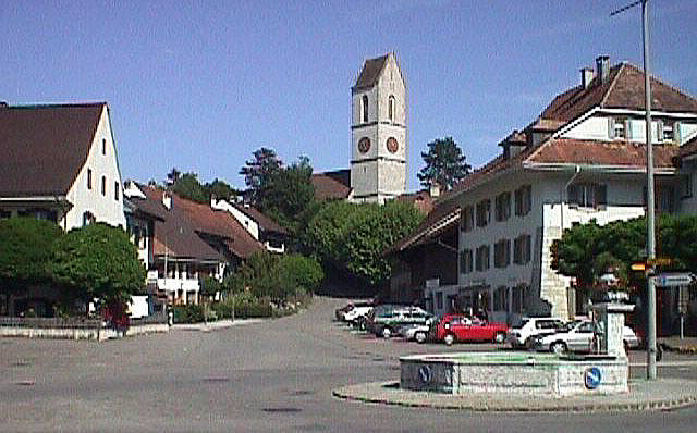
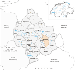
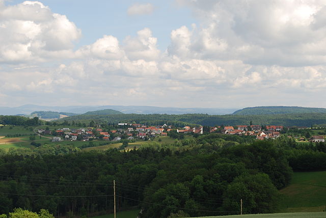
Зиссах
Hiking in Зиссах
Sissach is a picturesque municipality located in the Baselland region of Switzerland, surrounded by beautiful landscapes and natural beauty, making it an excellent destination for hiking enthusiasts. Here’s what you should know about hiking in Sissach:...
- Страна:
- Почтовый код: 4450
- Телефонный код: 061
- Код автомобильного номера: BL
- Координаты: 47° 28' 0" N, 7° 49' 0" E
- GPS треки (wikiloc): [Ссылка]
- Высота над уровнем моря: 372 м m
- Площадь: 8.87 кв.км
- Население: 6666
- Веб сайт: [Ссылка]
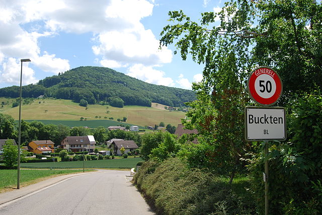

Буктен
Hiking in Буктен
Buckten is a charming village located in the canton of Aargau, Switzerland, surrounded by stunning natural scenery that makes it a great destination for hiking enthusiasts. The region offers a variety of hiking trails suitable for different levels of experience. Here's what you might want to know about hiking in and around Buckten:...
- Страна:
- Почтовый код: 4446
- Телефонный код: 062
- Код автомобильного номера: BL
- Координаты: 47° 24' 43" N, 7° 50' 48" E
- GPS треки (wikiloc): [Ссылка]
- Высота над уровнем моря: 516 м m
- Площадь: 1.99 кв.км
- Население: 694
- Веб сайт: [Ссылка]


Хеммикен
Hiking in Хеммикен
Hemmiken is a small municipality located in the Basel-Landschaft region of Switzerland, nestled just a short distance from the city of Basel. While Hemmiken itself may not be widely known for extensive hiking trails, its surrounding areas offer beautiful landscapes and opportunities for outdoor activities....
- Страна:
- Почтовый код: 4465
- Телефонный код: 061
- Код автомобильного номера: BL
- Координаты: 47° 29' 24" N, 7° 53' 28" E
- GPS треки (wikiloc): [Ссылка]
- Высота над уровнем моря: 525 м m
- Площадь: 3.39 кв.км
- Население: 251
- Веб сайт: [Ссылка]


Бёктен
Hiking in Бёктен
Böckten is a charming municipality located in the canton of Basel-Landschaft in Switzerland. The area around Böckten offers beautiful landscapes, lush nature, and a variety of hiking trails suitable for different skill levels....
- Страна:
- Почтовый код: 4461
- Телефонный код: 061
- Код автомобильного номера: BL
- Координаты: 47° 27' 45" N, 7° 50' 8" E
- GPS треки (wikiloc): [Ссылка]
- Высота над уровнем моря: 473 м m
- Площадь: 2.28 кв.км
- Население: 804
- Веб сайт: [Ссылка]


Ротенфлу
Hiking in Ротенфлу
Rothenfluh is a picturesque area in the Canton of Basel-Landschaft, Switzerland, known for its stunning landscapes and hiking opportunities. The region is characterized by its steep cliffs, lush forests, and beautiful valleys, making it an excellent destination for outdoor enthusiasts....
- Страна:
- Почтовый код: 4467
- Телефонный код: 061
- Код автомобильного номера: BL
- Координаты: 47° 27' 43" N, 7° 54' 58" E
- GPS треки (wikiloc): [Ссылка]
- Высота над уровнем моря: 477 м m
- Площадь: 10.93 кв.км
- Население: 780
- Веб сайт: [Ссылка]

Анвиль
Hiking in Анвиль
Hiking in Anwil, a picturesque area in Switzerland, offers stunning views and a variety of trails suitable for different skill levels. Located near the Jura Mountains, Anwil is known for its lush green landscapes, charming villages, and several well-marked hiking paths....
- Страна:
- Почтовый код: 4469
- Телефонный код: 061
- Код автомобильного номера: BL
- Координаты: 47° 27' 3" N, 7° 56' 29" E
- GPS треки (wikiloc): [Ссылка]
- Высота над уровнем моря: 614 м m
- Площадь: 3.96 кв.км
- Население: 569
- Веб сайт: [Ссылка]


Кильхберг
Hiking in Кильхберг
Kilchberg, located in the Basel-Landschaft canton of Switzerland, offers a scenic and enjoyable hiking experience. Nestled near the borders of both Basel and the picturesque Jura Mountains, it provides access to varied landscapes, including rolling hills, forests, and stunning views of the surrounding countryside....
- Страна:
- Почтовый код: 4496
- Телефонный код: 061
- Код автомобильного номера: BL
- Координаты: 47° 25' 32" N, 7° 53' 55" E
- GPS треки (wikiloc): [Ссылка]
- Высота над уровнем моря: 588 м m
- Площадь: 1.59 кв.км
- Население: 161
- Веб сайт: [Ссылка]

Венслинген
Hiking in Венслинген
Wenslingen is a picturesque village located in the canton of Basel-Landschaft in Switzerland, surrounded by stunning natural landscapes, making it a great destination for hiking enthusiasts. Here are some highlights and tips for hiking in and around Wenslingen:...
- Страна:
- Почтовый код: 4493
- Телефонный код: 061
- Код автомобильного номера: BL
- Координаты: 47° 26' 27" N, 7° 54' 30" E
- GPS треки (wikiloc): [Ссылка]
- Высота над уровнем моря: 579 м m
- Площадь: 5.91 кв.км
- Население: 717
- Веб сайт: [Ссылка]
Текнау
Hiking in Текнау
Tecknau is a picturesque village located in the Baselland region of Switzerland, surrounded by beautiful landscapes and scenic trails perfect for hiking enthusiasts. Here are some highlights for a hiking experience in and around Tecknau:...
- Страна:
- Почтовый код: 4492
- Телефонный код: 061
- Код автомобильного номера: BL
- Координаты: 47° 26' 43" N, 7° 53' 23" E
- GPS треки (wikiloc): [Ссылка]
- Высота над уровнем моря: 455 м m
- Площадь: 2.35 кв.км
- Население: 858
- Веб сайт: [Ссылка]

Рюненберг
Hiking in Рюненберг
Rünenberg, located in the canton of Baselland in Switzerland, is an excellent area for hiking enthusiasts. The region offers picturesque landscapes, charming farms, and views of the rolling hills typical of the Swiss countryside. Here are some highlights to consider when hiking in Rünenberg:...
- Страна:
- Почтовый код: 4497
- Телефонный код: 061
- Код автомобильного номера: BL
- Координаты: 47° 25' 55" N, 7° 52' 49" E
- GPS треки (wikiloc): [Ссылка]
- Высота над уровнем моря: 585 м m
- Площадь: 4.98 кв.км
- Население: 777
- Веб сайт: [Ссылка]
Дипфлинген
Hiking in Дипфлинген
Diepflingen, located in the beautiful region of Switzerland, is a fantastic destination for hiking enthusiasts. Nestled near the Swiss-German border, the area is characterized by stunning landscapes, rolling hills, lush forests, and charming countryside. Here are some key highlights for hiking in Diepflingen:...
- Страна:
- Почтовый код: 4442
- Телефонный код: 061
- Код автомобильного номера: BL
- Координаты: 47° 26' 42" N, 7° 50' 25" E
- GPS треки (wikiloc): [Ссылка]
- Высота над уровнем моря: 412 м m
- Площадь: 1.44 кв.км
- Население: 738
- Веб сайт: [Ссылка]
Тенникен
Hiking in Тенникен
Tenniken, while not widely recognized as a hiking destination, can refer to various hiking areas depending on the context. If you meant “Tennessee,” it is renowned for its beautiful landscapes and numerous hiking trails....
- Страна:
- Почтовый код: 4456
- Телефонный код: 061
- Код автомобильного номера: BL
- Координаты: 47° 26' 13" N, 7° 48' 40" E
- GPS треки (wikiloc): [Ссылка]
- Высота над уровнем моря: 423 м m
- Площадь: 4.67 кв.км
- Население: 916
- Веб сайт: [Ссылка]


Ормалинген
Hiking in Ормалинген
Ormalingen, located in Switzerland, is a charming village that offers beautiful hiking opportunities for outdoor enthusiasts. Nestled in the scenic region of Baselland, the area is characterized by lush forests, rolling hills, and stunning views of the surrounding landscapes....
- Страна:
- Почтовый код: 4466
- Телефонный код: 061
- Код автомобильного номера: BL
- Координаты: 47° 28' 23" N, 7° 52' 42" E
- GPS треки (wikiloc): [Ссылка]
- Высота над уровнем моря: 457 м m
- Площадь: 4.23 кв.км
- Население: 2201
- Веб сайт: [Ссылка]
Тюрнен
Hiking in Тюрнен
Thürnen, a picturesque village located in the German state of Baden-Württemberg, offers a range of hiking opportunities amidst beautiful natural landscapes. While 'Thürnen' might not be as renowned as some larger hiking destinations, it provides a peaceful and scenic environment for hikers looking to explore the Swabian Jura region....
- Страна:
- Почтовый код: 4441
- Телефонный код: 061
- Код автомобильного номера: BL
- Координаты: 47° 27' 26" N, 7° 49' 49" E
- GPS треки (wikiloc): [Ссылка]
- Высота над уровнем моря: 409 м m
- Площадь: 2.25 кв.км
- Население: 1403
- Веб сайт: [Ссылка]


Риккенбах
- община в Швейцарии, Базель-Ланд
Hiking in Риккенбах
Rickenbach, located in the Basel-Landschaft region of Switzerland, offers a range of scenic hiking opportunities. The area is characterized by lush green landscapes, rolling hills, and picturesque views, making it ideal for both casual walkers and serious hikers. Here are some key points to consider when hiking in Rickenbach:...
- Страна:
- Почтовый код: 4462
- Телефонный код: 061
- Код автомобильного номера: BL
- Координаты: 47° 29' 4" N, 7° 50' 57" E
- GPS треки (wikiloc): [Ссылка]
- Высота над уровнем моря: 466 м m
- Площадь: 2.90 кв.км
- Население: 594
- Веб сайт: [Ссылка]


Рюмлинген
Hiking in Рюмлинген
Rümlingen is a small village in Switzerland known for its picturesque landscapes and access to nature, making it a great spot for hiking enthusiasts. The region is characterized by rolling hills, lush meadows, and peaceful forests, providing a variety of trails suitable for different skill levels....
- Страна:
- Почтовый код: 4444
- Телефонный код: 062
- Код автомобильного номера: BL
- Координаты: 47° 25' 31" N, 7° 50' 59" E
- GPS треки (wikiloc): [Ссылка]
- Высота над уровнем моря: 459 м m
- Площадь: 2.28 кв.км
- Население: 390
- Веб сайт: [Ссылка]
Виттинсбург
Hiking in Виттинсбург
Wittinsburg is a picturesque area that offers a variety of hiking opportunities, surrounded by beautiful landscapes and natural scenery. While it may not be as popular as some well-known hiking destinations, it provides a great escape into nature for outdoor enthusiasts....
- Страна:
- Почтовый код: 4443
- Телефонный код: 062
- Код автомобильного номера: BL
- Координаты: 47° 25' 48" N, 7° 50' 21" E
- GPS треки (wikiloc): [Ссылка]
- Высота над уровнем моря: 599 м m
- Площадь: 321 кв.км
- Население: 434
- Веб сайт: [Ссылка]