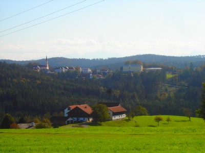
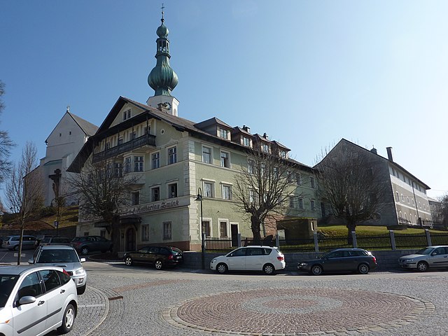
Хёнхарт (Höhnhart, Höhnhart)
- коммуна в Австрии
 Hiking in Хёнхарт
Höhnhart is a picturesque village located in the Upper Austria region, surrounded by beautiful landscapes that are ideal for hiking enthusiasts. The terrain offers a mix of gentle hills and more challenging paths, catering to hikers of all skill levels. Here are some key points to consider when hiking in Höhnhart:
Trails and Routes
-
Local Trails: There are numerous well-marked hiking trails that weave through the lush countryside, forests, and nearby hills. The trails often feature stunning views of the surrounding landscape.
-
Difficulty Levels: Routes vary from easy, family-friendly walks to more demanding hikes that may require some experience and preparation. It’s advisable to check trail maps and local guides for specifics.
-
Scenic Highlights: Many trails offer scenic vistas, opportunities to see local wildlife, and charming rural landscapes. Don’t miss the chance to explore nearby natural landmarks or enjoy a picnic along the way.
Preparation
-
Gear: Make sure to wear sturdy, comfortable footwear and bring along essentials like water, snacks, a map or GPS, sun protection, and possibly a first-aid kit.
-
Weather: Check the weather forecast before heading out, as conditions can change rapidly in the region. Dressing in layers is advisable.
-
Safety: Always inform someone of your hiking plans, particularly if you’re exploring more remote areas. Pay attention to trail markings and signs.
Local Amenities
-
Accommodations: If you plan to hike multiple days, consider local accommodations that cater to hikers, offering both comfort and convenience.
-
Dining: Look for local restaurants or inns where you can enjoy traditional Austrian cuisine after a day on the trails.
Community and Events
Höhnhart may host local events or hiking groups, offering a great way to meet fellow hikers and engage with the community. Check local tourism websites or community boards for information about guided hikes or events during your visit.
Whether you’re a seasoned hiker or a beginner looking to enjoy the outdoors, Höhnhart provides a wonderful setting for hiking adventures. Enjoy your time exploring the natural beauty of this region!
- Страна:

- Почтовый код: 5251
- Телефонный код: 07755
- Код автомобильного номера: BR
- Координаты: 48° 9' 52" N, 13° 16' 11" E


- GPS треки (wikiloc): [Ссылка]
- Высота над уровнем моря: 480 м m
- Площадь: 21.97 кв.км
- Население: 1379
- Веб сайт: http://www.hoehnhart.ooe.gv.at/
- Википедия русская: wiki(ru)
- Википедия английская: wiki(en)
- Википедия национальная: wiki(de)
- Хранилище Wikidata: Wikidata: Q669870
- Катеория в википедии: [Ссылка]
- код Freebase: [/m/03gv2bf]
- код GeoNames: Альт: [7871973]
- код VIAF: Альт: [246355060]
- код австрийского муниципалитета: [40415]
Граничит с регионами:
Тройбах
- коммуна в Австрии
Hiking in Тройбах
Treubach is likely a lesser-known location for hiking, as there isn't a widely recognized hiking destination by that name in popular hiking literature or resources. However, if you are referring to a specific region or a local area with that name, the details could vary significantly based on the local geography, trails, and natural features....
- Страна:
- Телефонный код: 07724
- Код автомобильного номера: BR
- Координаты: 48° 11' 42" N, 13° 12' 47" E
- GPS треки (wikiloc): [Ссылка]
- Высота над уровнем моря: 417 м m
- Площадь: 13.04 кв.км
- Население: 725
- Веб сайт: [Ссылка]
Мариа-Шмольн
Hiking in Мариа-Шмольн
Maria Schmolln is a picturesque village located in the state of Upper Austria, known for its beautiful landscapes and great hiking opportunities. The region is characterized by rolling hills, dense forests, and meadows, making it a delightful destination for both seasoned hikers and those looking for a leisurely stroll in nature....
- Страна:
- Почтовый код: 5241
- Телефонный код: 07743
- Код автомобильного номера: BR
- Координаты: 48° 8' 0" N, 13° 13' 0" E
- GPS треки (wikiloc): [Ссылка]
- Высота над уровнем моря: 557 м m
- Площадь: 34.5 кв.км
- Население: 1414
- Веб сайт: [Ссылка]
Санкт-Йохан-на-Вальде
Hiking in Санкт-Йохан-на-Вальде
Sankt Johann am Walde is a beautiful area in Austria, nestled in the scenic region of Upper Austria. It offers a variety of hiking opportunities suitable for different skill levels, making it an excellent destination for both casual walkers and experienced hikers....
- Страна:
- Почтовый код: 5242
- Телефонный код: 07743
- Код автомобильного номера: BR
- Координаты: 48° 7' 16" N, 13° 17' 2" E
- GPS треки (wikiloc): [Ссылка]
- Высота над уровнем моря: 623 м m
- Площадь: 39.99 кв.км
- Население: 2051
- Веб сайт: [Ссылка]
Росбах
- община в Австрии, Верхняя Австрия, Браунау-ам-Инн
Hiking in Росбах
Roßbach, Austria, is a beautiful destination for hiking enthusiasts, offering stunning natural landscapes, serene trails, and a pleasant climate. While it may be a smaller village, it is surrounded by the picturesque scenery of the Austrian countryside, making it an ideal base for exploring the region's trails....
- Страна:
- Почтовый код: 5273
- Код автомобильного номера: BR
- Координаты: 48° 12' 0" N, 13° 15' 10" E
- GPS треки (wikiloc): [Ссылка]
- Высота над уровнем моря: 442 м m
- Площадь: 14.92 кв.км
- Население: 935
- Веб сайт: [Ссылка]
Аспах
Hiking in Аспах
Aspach, located in Upper Austria, is a charming destination for hiking enthusiasts. The region is characterized by its picturesque landscapes, rolling hills, and lush forests, making it ideal for outdoor activities. Here are some key points to consider when hiking in Aspach:...
- Страна:
- Телефонный код: 07755
- Код автомобильного номера: BR
- Координаты: 48° 11' 10" N, 13° 18' 20" E
- GPS треки (wikiloc): [Ссылка]
- Высота над уровнем моря: 443 м m
- Площадь: 31.46 кв.км
- Население: 2596
- Веб сайт: [Ссылка]