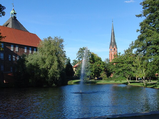
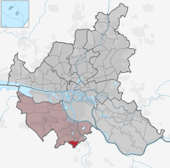
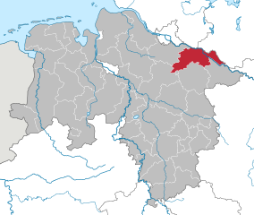
Харбург (Harburg, Landkreis Harburg)


- район в земле Нижняя Саксония (Германия)
 Hiking in Харбург
Harburg, a district in the southern part of Hamburg, Germany, offers various hiking opportunities that allow you to explore the beautiful natural landscapes and scenic views of the region. Here are some key points about hiking in Harburg:
1. Natural Parks:
- Harburger Stadtpark: A popular park with well-marked trails, it provides a lovely environment for family hikes and leisurely strolls. The park features ponds, green meadows, and plenty of trees, making it a great spot for a quick hike.
- Lüneburg Heath Nature Reserve: Although a bit further outside Harburg, this renowned nature reserve is known for its stunning heathland landscapes and offers extensive hiking trails. If you are up for a day trip, it's worth exploring.
2. Hiking Trails:
- The Harburger Hills (Harburger Berge): This area features trails that wind through forests, hills, and fields, giving hikers beautiful vistas of the surrounding countryside. Most trails are well-maintained and suitable for a range of hiking abilities.
- Fischbeker Heide: Located nearby, this heathland offers a variety of trails that are perfect for hiking. The unique landscape is home to many plant and animal species, providing a rich nature experience.
3. Accessibility:
- Harburg is well connected by public transport, including S-Bahn and bus services, making it easy to access hiking destinations without the need for a car.
4. Recommendations:
- Always check the weather before heading out, as conditions can change quickly.
- Wear appropriate footwear and clothing suited for hiking.
- Carry enough water and snacks, especially on longer hikes.
- Respect nature and local wildlife by sticking to designated trails.
5. Guided Hikes:
- Consider joining a guided hike if you want to learn more about the flora and fauna of the area or if you're unfamiliar with the trails. Local hiking clubs often organize events for various skill levels.
6. Additional Activities:
- Besides hiking, Harburg offers opportunities for cycling, picnicking, and bird watching, which can enhance your outdoor experience.
Exploring the natural beauty of Harburg through hiking can be a rewarding experience, combining exercise with the chance to appreciate the region's unique landscapes.
- Страна:

- Столица: Винзен
- Код автомобильного номера: WL
- Координаты: 53° 19' 43" N, 9° 58' 11" E


- GPS треки (wikiloc): [Ссылка]
- Высота над уровнем моря: 49 м m
- Население: 250326
- Веб сайт: https://www.landkreis-harburg.de/
- Википедия русская: wiki(ru)
- Википедия английская: wiki(en)
- Википедия национальная: wiki(de)
- Хранилище Wikidata: Wikidata: Q5907
- Галерея изображений в википедии: [Ссылка]
- Катеория в википедии: [Ссылка]
- Карты в википедии: [Ссылка]
- код Freebase: [/m/012ync]
- код Freebase: [/m/012ync]
- код GeoNames: Альт: [2910684]
- код GeoNames: Альт: [2910684]
- код VIAF: Альт: [126671193]
- код VIAF: Альт: [126671193]
- ID отношения в OpenStreetMap: [2083497]
- ID отношения в OpenStreetMap: [2083497]
- код GND: Альт: [4023413-7]
- код GND: Альт: [4023413-7]
- идентификатор местоположения ArchINFORM: [2447]
- идентификатор местоположения ArchINFORM: [2447]
- код LCNAF: Альт: [n80123453]
- код LCNAF: Альт: [n80123453]
- код NLI: [000981285]
- код NLI: [000981285]
- код NUTS: [DE933]
- код NUTS: [DE933]
- код BabelNet: [14366958n]
- код BabelNet: [14366958n]
- код района Германии: 03353
- код района Германии: 03353
Включает регионы:


Буххольц-ин-дер-Нордхайде
- Рудольф
Hiking in Буххольц-ин-дер-Нордхайде
Buchholz in der Nordheide, located in Lower Saxony, Germany, is surrounded by picturesque landscapes that offer excellent opportunities for hiking. While it may not be as well-known as some of Germany's larger hiking destinations, it has several trails and natural areas that can be quite appealing for outdoor enthusiasts....
- Страна:
- Почтовый код: 21244
- Телефонный код: 04181
- Код автомобильного номера: WL
- Координаты: 53° 19' 43" N, 9° 51' 43" E
- GPS треки (wikiloc): [Ссылка]
- Высота над уровнем моря: 55 м m
- Площадь: 74.62 кв.км
- Население: 38689
- Веб сайт: [Ссылка]


Финкенвердер
- район Гамбурга
Hiking in Финкенвердер
Finkenwerder is a district in Hamburg, Germany, located on the Elbe River. While it is primarily known as a residential and industrial area, it offers some pleasant opportunities for walking and enjoying nature, especially along the river....
- Страна:
- Почтовый код: 21129
- Координаты: 53° 32' 24" N, 9° 49' 48" E
- GPS треки (wikiloc): [Ссылка]
- Высота над уровнем моря: 4 м m
- Площадь: 19.3 кв.км

Винзен
Hiking in Винзен
Winsen (Luhe), a charming town located in Lower Saxony, Germany, offers various hiking opportunities that are perfect for outdoor enthusiasts. The region features beautiful landscapes, rich nature, and scenic trails....
- Страна:
- Почтовый код: 21423
- Телефонный код: 04171
- Код автомобильного номера: WL
- Координаты: 53° 21' 27" N, 10° 12' 46" E
- GPS треки (wikiloc): [Ссылка]
- Высота над уровнем моря: 5 м m
- Площадь: 109.55 кв.км
- Население: 34635
- Веб сайт: [Ссылка]


Elbmarsch
Hiking in Elbmarsch
Elbmarsch, located in Lower Saxony, Germany, is a beautiful area characterized by its diverse landscapes, including forests, meadows, rivers, and marshes, along with the Elbe River flowing through it. Here are some highlights and tips for hiking in Elbmarsch:...
- Страна:
- Координаты: 53° 24' 58" N, 10° 22' 35" E
- GPS треки (wikiloc): [Ссылка]
- Население: 12451
- Веб сайт: [Ссылка]
Fischbek
Hiking in Fischbek
Fischbek is a picturesque area located in the south of Hamburg, Germany. It is known for its beautiful natural landscapes, making it a great spot for hiking and outdoor activities. Here are some highlights you might consider when hiking in Fischbek:...
- Страна:
- Координаты: 53° 28' 17" N, 9° 49' 50" E
- GPS треки (wikiloc): [Ссылка]
Nenndorf
Hiking in Nenndorf
Nenndorf is a small village located in Lower Saxony, Germany. While it may not be a well-known hiking destination, the surrounding areas do offer opportunities for enjoying nature and hiking. Here are some points to consider when planning a hiking trip in and around Nenndorf:...
- Страна:
- Координаты: 53° 23' 0" N, 9° 54' 0" E
- GPS треки (wikiloc): [Ссылка]
Кирхвердер
- пригород района Бергедорфа (Гамбург)
Hiking in Кирхвердер
Kirchwerder is a district located in the southeastern part of Hamburg, Germany, and while it is primarily known for its rural charm and waterways, there are some great opportunities for hiking and enjoying the natural surroundings....
- Страна:
- Координаты: 53° 25' 11" N, 10° 12' 6" E
- GPS треки (wikiloc): [Ссылка]
- Площадь: 32.4 кв.км
- Население: 8669
Bötersheim
Hiking in Bötersheim
Bötersheim, a small area in Germany, offers a variety of hiking opportunities for nature enthusiasts. While it may not be widely known as a hiking hotspot, nearby regions often provide access to beautiful trails, scenic landscapes, and a chance to experience local flora and fauna....
- Страна:
- Координаты: 53° 19' 19" N, 9° 44' 53" E
- GPS треки (wikiloc): [Ссылка]
Neugraben
Hiking in Neugraben
Neugraben, located in the southern part of Hamburg, Germany, offers a unique blend of urban green spaces and natural landscapes that are perfect for hiking enthusiasts. While not as mountainous as some other regions, it is characterized by its picturesque parks and nearby nature reserves, providing excellent opportunities for outdoor activities....
- Страна:


Альтенвердер
- квартал в Гамбурге
Hiking in Альтенвердер
Altenwerder, a quarter in Hamburg, Germany, isn't typically known as a hiking destination, but there are still outdoor spaces that can provide a pleasant experience for walkers and nature enthusiasts. While the area itself may not have designated hiking trails like more rural locations, there are opportunities for both casual walking and exploring nearby parks or natural environments....
- Страна:
- Координаты: 53° 30' 25" N, 9° 55' 4" E
- GPS треки (wikiloc): [Ссылка]
- Высота над уровнем моря: 3 м m
- Площадь: 6.8 кв.км
- Население: 3
- Веб сайт: [Ссылка]


Francop
Hiking in Francop
It seems there might be a misunderstanding regarding the name "Francop." There’s no widely recognized hiking destination or region by that name in popular hiking resources. However, it’s possible you could be referring to a specific locality not well-documented or known by a different name....
- Страна:
- Телефонный код: 040
- Координаты: 53° 30' 29" N, 9° 51' 10" E
- GPS треки (wikiloc): [Ссылка]
- Высота над уровнем моря: -2 м m
- Площадь: 9.1 кв.км


Гут-Мор
- квартал в Гамбурге
Hiking in Гут-Мор
Gut Moor is a beautiful natural area that offers a variety of hiking opportunities. This scenic locale is known for its diverse landscapes, including wetlands, forests, and open fields, making it a great place for both casual walkers and more experienced hikers. Here are some key points to consider when hiking in Gut Moor:...
- Страна:
- Координаты: 53° 26' 57" N, 10° 0' 55" E
- GPS треки (wikiloc): [Ссылка]
- Высота над уровнем моря: -1 м m
- Площадь: 1.97 кв.км


Лангенбек
- квартал в Гамбурге
Hiking in Лангенбек
Langenbek is a small neighborhood located in the city of Hamburg, Germany. While it may not be widely known as a hiking destination, there are scenic spots and parks in and around Hamburg where you can enjoy hiking and nature walks. Here are some tips and information about hiking in the Langenbek area and nearby locations:...
- Страна:
- Почтовый код: 21079; 21075; 21073
- Координаты: 53° 25' 53" N, 9° 59' 22" E
- GPS треки (wikiloc): [Ссылка]
- Высота над уровнем моря: 79 м m
- Площадь: 0.8 кв.км
- Население: 4020
- Веб сайт: [Ссылка]


Мармсторф
- квартал в Гамбурге
Hiking in Мармсторф
Marmstorf, while not extensively known as a hiking destination, is a suburb of Hamburg, Germany, and offers some beautiful opportunities for local walks and nature exploration. The surrounding areas of Hamburg provide access to several parks and green spaces which can make for pleasant hiking experiences. Here are some points to consider if you're looking to hike in and around Marmstorf:...
- Страна:
- Координаты: 53° 26' 9" N, 9° 58' 7" E
- GPS треки (wikiloc): [Ссылка]
- Площадь: 5.8 кв.км


Нойенфельде
- квартал в Гамбурге
Hiking in Нойенфельде
Neuenfelde is a district located in the Hamburg-Harburg region of Germany. While it is primarily a residential area, it is surrounded by beautiful natural landscapes, making it a suitable spot for hiking and outdoor activities....
- Страна:
- Координаты: 53° 30' 53" N, 9° 47' 44" E
- GPS треки (wikiloc): [Ссылка]
- Высота над уровнем моря: 2 м m
- Площадь: 15.5 кв.км
- Население: 4671


Нойланд
- квартал в Гамбурге
Hiking in Нойланд
Hiking in Neuland, a district in Hamburg, can be a rewarding experience, especially if you're looking to explore the more tranquil, natural aspects of the city. While Hamburg is primarily known for its urban spaces, Neuland offers opportunities to enjoy the outdoors. Here are some key points to consider:...
- Страна:
- Почтовый код: 21079
- Координаты: 53° 28' 16" N, 10° 1' 29" E
- GPS треки (wikiloc): [Ссылка]
- Высота над уровнем моря: -1 м m
- Площадь: 8.045 кв.км
- Население: 1571


Рённебург
- квартал в Гамбурге
Hiking in Рённебург
Rönneburg, located in northern Germany, is a charming area that offers a variety of hiking opportunities. The region is characterized by its scenic landscapes, including forests, fields, and rolling hills. Here are some highlights and tips for hiking in Rönneburg:...
- Страна:
- Координаты: 53° 26' 15" N, 10° 0' 16" E
- GPS треки (wikiloc): [Ссылка]
- Высота над уровнем моря: 45 м m
- Площадь: 2.3 кв.км

Зинсторф
- квартал в Гамбурге
Hiking in Зинсторф
Sinstorf is a neighborhood located in the city of Hamburg, Germany, known for its scenic landscapes and proximity to nature. While it may not be a typical hiking destination like national parks or mountainous regions, there are still opportunities for walking and exploring the outdoors in and around Sinstorf....
- Страна:
- Координаты: 53° 25' 26" N, 9° 58' 50" E
- GPS треки (wikiloc): [Ссылка]
- Площадь: 2.6 кв.км


Холленштедт
Hiking in Холленштедт
Hollenstedt is located in Lower Saxony, Germany, and is part of the larger Samtgemeinde Hollenstedt. While it may not be as widely known for hiking as some larger national parks or nature reserves, this area offers various outdoor activities and scenic landscapes for hiking enthusiasts....
- Страна:
- Координаты: 53° 21' 58" N, 9° 42' 48" E
- GPS треки (wikiloc): [Ссылка]
- Население: 11526
- Веб сайт: [Ссылка]


Jesteburg
Hiking in Jesteburg
Jesteburg, located in the district of Harburg in Lower Saxony, Germany, offers a variety of hiking opportunities that cater to all levels of experience. The region is characterized by its lush forests, rolling hills, and picturesque scenery, making it an ideal destination for outdoor enthusiasts. Here are some highlights:...
- Страна:
- Координаты: 53° 18' 28" N, 9° 57' 15" E
- GPS треки (wikiloc): [Ссылка]
- Население: 11224
- Веб сайт: [Ссылка]


Зальцхаузен
Hiking in Зальцхаузен
Salzhausen is a charming village located in the Samtgemeinde Salzhausen in Germany, known for its beautiful landscapes and outdoor activities, including hiking. The area is characterized by its lush forests, meadows, and gently rolling hills, making it an excellent destination for nature lovers and hikers....
- Страна:
- Координаты: 53° 13' 48" N, 10° 10' 12" E
- GPS треки (wikiloc): [Ссылка]
- Население: 14434
- Веб сайт: [Ссылка]


Hanstedt
Hiking in Hanstedt
Hanstedt, located in Lower Saxony, Germany, offers a variety of hiking opportunities in a picturesque, rural setting. The area is characterized by its natural beauty, including forests, fields, and scenic landscapes that attract nature lovers and outdoor enthusiasts....
- Страна:
- Координаты: 53° 16' 12" N, 10° 1' 12" E
- GPS треки (wikiloc): [Ссылка]
- Население: 14402
- Веб сайт: [Ссылка]


Тоштедт
- административная единица в Нижней Саксонии
Hiking in Тоштедт
Tostedt, located in the Samtgemeinde area of Lower Saxony, Germany, offers a serene backdrop for hiking enthusiasts. The region features a mix of scenic countryside, forests, and charming villages, making it an ideal destination for both casual walkers and more serious hikers....
- Страна:
- Координаты: 53° 17' 0" N, 9° 43' 0" E
- GPS треки (wikiloc): [Ссылка]
- Площадь: 221.29 кв.км
- Население: 26497
- Веб сайт: [Ссылка]


Розенгартен
Hiking in Розенгартен
Rosengarten, located in Lower Saxony, Germany, offers hikers a beautiful landscape characterized by its rolling hills, dense forests, and scenic views. The area is part of the Lüneburg Heath, known for its unique heathland ecosystems and diverse flora and fauna....
- Страна:
- Почтовый код: 21224
- Телефонный код: 04108; 04105; 040
- Код автомобильного номера: WL
- Координаты: 53° 23' 0" N, 9° 54' 0" E
- GPS треки (wikiloc): [Ссылка]
- Высота над уровнем моря: 85 м m
- Площадь: 63.67 кв.км
- Население: 14031
- Веб сайт: [Ссылка]


Ной-Вульмсторф
Hiking in Ной-Вульмсторф
Neu Wulmstorf is located in Lower Saxony, Germany, and while it may not be a major hiking destination like some national parks, it does offer some pleasant outdoor experiences for those looking to enjoy nature and hiking....
- Страна:
- Почтовый код: 21629
- Телефонный код: 04168; 040
- Код автомобильного номера: WL
- Координаты: 53° 25' 22" N, 9° 47' 23" E
- GPS треки (wikiloc): [Ссылка]
- Высота над уровнем моря: 49 м m
- Площадь: 56.16 кв.км
- Население: 21159
- Веб сайт: [Ссылка]


Штелле
Hiking in Штелле
Stelle, a small municipality in Lower Saxony, Germany, offers a peaceful setting for hiking enthusiasts, particularly for those who enjoy exploring rural landscapes. While the area itself may not be as well-known for hiking as larger national parks or mountainous regions, it provides a variety of trails and natural scenery worth exploring....
- Страна:
- Почтовый код: 21435
- Телефонный код: 04174
- Код автомобильного номера: WL
- Координаты: 53° 22' 0" N, 10° 7' 0" E
- GPS треки (wikiloc): [Ссылка]
- Высота над уровнем моря: 8 м m
- Площадь: 38.50 кв.км
- Население: 11102
- Веб сайт: [Ссылка]

Зеветаль
Hiking in Зеветаль
Seevetal, located in Lower Saxony, Germany, is not only a charming area with beautiful landscapes but also offers some wonderful hiking opportunities. The region is characterized by its lush forests, picturesque rivers, and scenic countryside. Here are some highlights and tips for hiking in Seevetal:...
- Страна:
- Почтовый код: 21217–21220
- Телефонный код: 040; 04185; 04105
- Код автомобильного номера: WL
- Координаты: 53° 23' 0" N, 10° 2' 0" E
- GPS треки (wikiloc): [Ссылка]
- Высота над уровнем моря: 14 м m
- Площадь: 105.10 кв.км
- Население: 41234
- Веб сайт: [Ссылка]
Граничит с регионами:

Харбург
- район в Гамбурге
Hiking in Харбург
Harburg, a district located in the southern part of Hamburg, offers a blend of urban and natural landscapes, making it an interesting area for hiking. While it may not have the rugged wilderness found in more remote hiking areas, there are still plenty of scenic routes and parks to explore....
- Страна:
- Столица: Харбург
- Координаты: 53° 27' 0" N, 9° 58' 0" E
- GPS треки (wikiloc): [Ссылка]
- Высота над уровнем моря: 10 м m
- Площадь: 161 кв.км

Бергедорф
- район Гамбурга
Hiking in Бергедорф
Bergedorf, a district in Hamburg, Germany, is known for its picturesque landscapes and outdoor opportunities. While it may not be a traditional hiking destination, there are several routes and natural parks in and around the area that provide great walking and hiking experiences. Here are some highlights:...
- Страна:
- Координаты: 53° 29' 14" N, 10° 12' 37" E
- GPS треки (wikiloc): [Ссылка]
- Высота над уровнем моря: 17 м m
- Площадь: 154.8 кв.км
- Население: 129111
- Веб сайт: [Ссылка]
Герцогство Лауэнбург
- район в Германии
Hiking in Герцогство Лауэнбург
Herzogtum Lauenburg is a picturesque region in northern Germany, known for its scenic landscapes, rich history, and charming towns. If you're considering hiking in this area, you'll find a variety of trails and natural attractions that cater to different skill levels. Here are some highlights and tips for hiking in Herzogtum Lauenburg:...
- Страна:
- Код автомобильного номера: RZ
- Координаты: 53° 35' 0" N, 10° 40' 0" E
- GPS треки (wikiloc): [Ссылка]
- Высота над уровнем моря: 35 м m
- Площадь: 1262.97 кв.км
- Население: 192999
- Веб сайт: [Ссылка]


Штаде
- район земли Нижняя Саксония, Германия
Hiking in Штаде
Stade, located in Lower Saxony, Germany, offers a range of hiking opportunities that allow you to explore its picturesque natural landscapes, historical sites, and charming small towns. Here are some highlights for hiking in the Stade district:...
- Страна:
- Код автомобильного номера: STD
- Координаты: 53° 34' 48" N, 9° 25' 12" E
- GPS треки (wikiloc): [Ссылка]
- Высота над уровнем моря: 1 м m
- Площадь: 1266.00 кв.км
- Население: 201638
- Веб сайт: [Ссылка]

Люнебург
- район Нижней Саксонии
Hiking in Люнебург
Lüneburg district, located in Lower Saxony, Germany, is a wonderful area for hiking enthusiasts. The region is known for its scenic landscapes, featuring rolling hills, forests, rivers, and charming villages. Here are some highlights for hiking in Lüneburg:...
- Страна:
- Столица: Люнебург
- Код автомобильного номера: LG
- Координаты: 53° 15' 0" N, 10° 30' 0" E
- GPS треки (wikiloc): [Ссылка]
- Высота над уровнем моря: 8 м m
- Площадь: 1323.10 кв.км
- Население: 181605
- Веб сайт: [Ссылка]


Зольтау-Фаллингбостель
Hiking in Зольтау-Фаллингбостель
Heidekreis, located in Lower Saxony, Germany, offers a variety of hiking opportunities amidst beautiful natural landscapes. The region is characterized by its mix of heathlands, forests, and moorlands, making it an attractive destination for outdoor enthusiasts....
- Страна:
- Столица: Бад-Фаллингбостель
- Код автомобильного номера: HK
- Координаты: 52° 55' 12" N, 9° 45' 0" E
- GPS треки (wikiloc): [Ссылка]
- Высота над уровнем моря: 64 м m
- Площадь: 1873.50 кв.км
- Население: 139641
- Веб сайт: [Ссылка]


Ротенбург-на-Вюмме
Hiking in Ротенбург-на-Вюмме
Rotenburg (district), located in Lower Saxony, Germany, offers various hiking opportunities, particularly for those interested in exploring scenic landscapes and natural beauty. Here are some highlights and suggestions for hiking in this region:...
- Страна:
- Код автомобильного номера: ROW; BRV
- Координаты: 53° 15' 0" N, 9° 19' 48" E
- GPS треки (wikiloc): [Ссылка]
- Высота над уровнем моря: 28 м m
- Население: 163372
- Веб сайт: [Ссылка]