
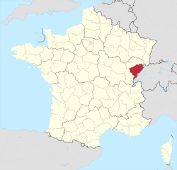
Верхняя Сона (Haute-Saône, Haute-Saône)

- департамент Франции
 Hiking in Верхняя Сона
Haute-Saône, located in the Bourgogne-Franche-Comté region of eastern France, offers a variety of beautiful hiking opportunities thanks to its diverse landscapes, which include rolling hills, forests, rivers, and charming villages. Here are some highlights of hiking in Haute-Saône:
Key Hiking Areas
-
The Vosges Mountains: While not entirely in Haute-Saône, the foothills and surrounding areas offer access to scenic trails. You can explore picturesque routes with panoramic views, especially in autumn when the foliage changes colors.
-
Forests and Nature Reserves: The region is known for its extensive forests. The Forêt de la Saint-Maurice is a popular destination for hikers looking to experience the tranquility of nature. You'll find well-marked trails perfect for both short walks and longer treks.
-
Plateau des Mille ÉTangs: This area, known for its numerous ponds, offers a unique landscape. The plateau features various trails that allow hikers to explore the serene waters surrounded by lush vegetation.
-
Cascades and Rivers: Hike along the rivers, such as the Saône, which provides opportunities for trails that wind alongside water features, offering both scenic views and the sounds of nature.
Hiking Tips
-
Trail Maps: Make sure to grab trail maps or guides from local tourism offices or online resources. Many trails are well-marked, but having a map can help you navigate less clear paths.
-
Seasonal Considerations: Spring and autumn are ideal times for hiking in Haute-Saône due to moderate temperatures and beautiful landscapes. Summers can get warm, while winters may have snow in higher elevations.
-
Local Culture: Take time to explore charming villages like Luxey, Villersexel, or Frotey-lès-Vesoul, which offer a glimpse into local culture and history. Many trails might lead you to these picturesque spots.
-
Pack Accordingly: Bring plenty of water, snacks, and weather-appropriate clothing. Hiking footwear with good traction is essential, especially if you encounter rocky or muddy trails.
Guided Hikes
If you're new to the area or hiking in general, consider joining a guided hike. Local guides can offer insights into the flora, fauna, and history of the region.
Conclusion
Hiking in Haute-Saône presents a blend of natural beauty, diverse trails, and cultural experiences. Whether you're seeking a peaceful day in the woods or an adventurous trek in the hills, this region has something to offer for every level of hiker. Always check local resources for updated trail information and conditions before hitting the trails. Enjoy your hiking adventure!
- Страна:

- Столица: Везуль
- Координаты: 47° 35' 0" N, 6° 0' 0" E


- GPS треки (wikiloc): [Ссылка]
- Площадь: 5360 кв.км
- Население: 237706
- Веб сайт: http://www.haute-saone.pref.gouv.fr/
- Википедия русская: wiki(ru)
- Википедия английская: wiki(en)
- Википедия национальная: wiki(fr)
- Хранилище Wikidata: Wikidata: Q12730
- Галерея изображений в википедии: [Ссылка]
- Катеория в википедии: [Ссылка]
- Карты в википедии: [Ссылка]
- код Freebase: [/m/0mhjc]
- код GeoNames: Альт: [3013737]
- номер SIREN: [227000015]
- код BNF: [11864285n]
- код VIAF: Альт: [134397315]
- ID отношения в OpenStreetMap: [7423]
- код GND: Альт: [4239287-1]
- идентификатор местоположения ArchINFORM: [2728]
- код тезауруса PACTOLS: [pcrtSR4b3hzGMi]
- место в MusicBrainz: [534162b0-508e-4d10-9514-4b4dc4c3a6ec]
- код TGN: [7002945]
- код SUDOC: [026385279]
- код в энциклопедии «Британника онлайн»: [place/Haute-Saone]
- код в Большой каталанской энциклопедии: [0003164]
- код NUTS: [FR433]
- код департамента Франции INSEE: [70]
- ISO 3166-2: FR-70
Включает регионы:


Люр
- округ Франции
Hiking in Люр
The Arrondissement of Lure, located in the Haute-Saône department within the Bourgogne-Franche-Comté region of France, offers a range of scenic hiking opportunities. The landscape is characterized by rolling hills, forests, and picturesque villages, making it an appealing destination for both novice and experienced hikers....
- Страна:
- Столица: Люр
- Координаты: 47° 45' 0" N, 6° 30' 0" E
- GPS треки (wikiloc): [Ссылка]
- Площадь: 1848 кв.км
- Население: 109726


Везуль
- округ Франции
Hiking in Везуль
The Arrondissement of Vesoul is a beautiful region located in the Haute-Saône department in the Bourgogne-Franche-Comté region of eastern France. It's characterized by a stunning landscape of rolling hills, forests, and charming villages, making it an appealing destination for hiking enthusiasts. Here are some key highlights for hiking in this area:...
- Страна:
- Столица: Везуль
- Координаты: 47° 35' 0" N, 5° 50' 0" E
- GPS треки (wikiloc): [Ссылка]
- Площадь: 35120 кв.км
- Население: 127980

Вовиллер
- коммуна во Франции, департамент Верхняя Сона
- Страна:
- Почтовый код: 70210
- Координаты: 47° 55' 21" N, 6° 5' 51" E
- GPS треки (wikiloc): [Ссылка]
- Площадь: 9.5 кв.км
- Население: 674

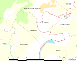
Ла-Бар
- коммуна во Франции, департамент Верхняя Сона
Hiking in Ла-Бар
La Barre, located in the Haute-Saône department in the Bourgogne-Franche-Comté region of eastern France, offers a variety of hiking opportunities that showcase the region's beautiful landscapes, rolling hills, and rich biodiversity. Here are some key points to consider for hiking in La Barre and the surrounding areas:...
- Страна:
- Почтовый код: 70190
- Координаты: 47° 24' 17" N, 6° 10' 47" E
- GPS треки (wikiloc): [Ссылка]
- Высота над уровнем моря: 210 м m
- Площадь: 1.93 кв.км
- Население: 103
Граничит с регионами:


Верхняя Марна
- департамент Франции
- Страна:
- Столица: Шомон
- Координаты: 48° 5' 0" N, 5° 15' 0" E
- GPS треки (wikiloc): [Ссылка]
- Площадь: 6211 кв.км
- Население: 179154
- Веб сайт: [Ссылка]

Территория Бельфор
- департамент Франции
Hiking in Территория Бельфор
The Territoire de Belfort, located in the Bourgogne-Franche-Comté region of eastern France, offers a variety of hiking opportunities amidst its diverse landscapes. Here are some key aspects of hiking in this area:...
- Страна:
- Столица: Бельфор
- Координаты: 47° 45' 0" N, 7° 0' 0" E
- GPS треки (wikiloc): [Ссылка]
- Площадь: 609.4 кв.км
- Население: 144483
- Веб сайт: [Ссылка]


Вогезы
- департамент Франции
- Страна:
- Столица: Эпиналь
- Координаты: 48° 10' 0" N, 6° 25' 0" E
- GPS треки (wikiloc): [Ссылка]
- Площадь: 5874 кв.км
- Население: 372016
- Веб сайт: [Ссылка]

Юра
- департамент Франции
Hiking in Юра
Hiking in the Jura department, located in the Bourgogne-Franche-Comté region of eastern France, presents a remarkable opportunity to explore stunning natural landscapes, rich biodiversity, and charming villages. The Jura mountain range, characterized by its rolling hills, dense forests, and picturesque lakes, offers diverse hiking trails suitable for all levels of hikers....
- Страна:
- Столица: Лонс-ле-Сонье
- Координаты: 46° 40' 31" N, 5° 33' 16" E
- GPS треки (wikiloc): [Ссылка]
- Площадь: 4999 кв.км
- Население: 260587
- Веб сайт: [Ссылка]

Кот-д’Ор
- департамент Франции
- Страна:
- Столица: Дижон
- Координаты: 47° 25' 0" N, 4° 50' 0" E
- GPS треки (wikiloc): [Ссылка]
- Площадь: 8763 кв.км
- Население: 533147
- Веб сайт: [Ссылка]

Ду
- департамент Франции
Hiking in Ду
Hiking in the Doubs region, located in eastern France, offers stunning landscapes and a rich natural heritage. The Doubs department is known for its rugged terrain, deep valleys, and diverse ecosystems, making it a wonderful destination for outdoor enthusiasts. Here are some highlights and recommendations for hiking in the area:...
- Страна:
- Столица: Безансон
- Координаты: 47° 10' 0" N, 6° 25' 0" E
- GPS треки (wikiloc): [Ссылка]
- Площадь: 5234 кв.км
- Население: 536959
- Веб сайт: [Ссылка]