
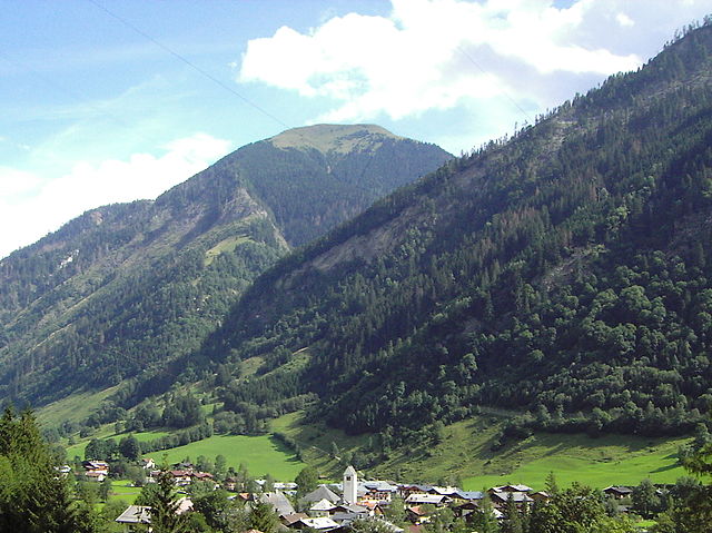
Хайлигенблут (Heiligenblut, Heiligenblut am Großglockner)
 Hiking in Хайлигенблут
Heiligenblut am Großglockner is a picturesque village located in the Austrian Alps, known for its stunning landscapes and access to hiking trails around the Großglockner, Austria's highest mountain. Here are some key highlights for hiking in this beautiful region:
Scenic Trails
-
Großglockner High Alpine Road: This panoramic road offers several access points to hiking trails with breathtaking views. You can explore various hiking routes from different viewpoints along the road.
-
Glocknerblick Trail: A moderately challenging hike that provides stunning views of the Großglockner and surrounding peaks. This trail is great for capturing picturesque photos.
-
Schleierwasserfall (Veil Waterfall): This is a family-friendly hike that leads to a beautiful waterfall. It's a relatively easy trail suitable for all ages.
-
Fleißtal Valley: This trail offers a more varied terrain, allowing you to immerse yourself in the nature of the Hohe Tauern National Park. The valley is home to diverse flora and fauna.
Hohe Tauern National Park
Heiligenblut is situated at the edge of the Hohe Tauern National Park, Austria's largest national park. The area is renowned for its biodiversity, featuring alpine flowers, and wildlife such as chamois and golden eagles. Hiking in the park allows you to experience its rich natural beauty.
Seasonal Considerations
-
Summer (June to September): This is the best season for hiking, with stable weather and virtually all trails open. It's advisable to check the trail conditions as some routes can be challenging, and higher altitudes may still have snow.
-
Autumn (October): The fall colors are stunning, but be prepared for rapidly changing weather conditions. Early snows can also impact higher trails.
Safety Tips
- Weather Awareness: Always check the local weather forecasts before heading out, as conditions can change quickly in the mountains.
- Gear Up: Wear appropriate hiking boots and bring essential gear like layers of clothing, water, snacks, and a first aid kit.
- Map and GPS: Familiarize yourself with the area using hiking maps, and consider downloading offline maps or using a GPS device for navigation.
Local Amenities
Heiligenblut has several accommodations, ranging from hotels to guesthouses, and you’ll find dining options to recharge after a day of hiking. Local guides are available for those who prefer to hike with an experienced leader.
Conclusion
Hiking in Heiligenblut am Großglockner offers something for everyone, from families to experienced trekkers. The blend of stunning landscapes, rich wildlife, and varied trails make it a prime destination for outdoor enthusiasts. Always ensure you're prepared for the conditions, and enjoy exploring this breathtaking region of the Austrian Alps!
- Страна:

- Почтовый код: 9844
- Телефонный код: 0 48 24
- Код автомобильного номера: SP
- Координаты: 47° 2' 29" N, 12° 50' 13" E


- GPS треки (wikiloc): [Ссылка]
- Высота над уровнем моря: 1288 м m
- Площадь: 193.5 кв.км
- Население: 1020
- Веб сайт: http://www.heiligenblut.at
- Википедия русская: wiki(ru)
- Википедия английская: wiki(en)
- Википедия национальная: wiki(de)
- Хранилище Wikidata: Wikidata: Q875812
- Галерея изображений в википедии: [Ссылка]
- Катеория в википедии: [Ссылка]
- код Freebase: [/m/02qqg6j]
- код GeoNames: Альт: [2776595]
- код VIAF: Альт: [149564424]
- код GND: Альт: [4089190-2]
- идентификатор местоположения ArchINFORM: [10250]
- код LCNAF: Альт: [n81134796]
- код австрийского муниципалитета: [20610]
Граничит с регионами:

Фуш-ан-дер-Гросглокнерштрассе
Hiking in Фуш-ан-дер-Гросглокнерштрассе
Fusch an der Großglocknerstraße is a picturesque village in Austria, nestled at the gateway to the Hohe Tauern National Park and near the famous Großglockner mountain, the highest peak in Austria. This area is a hiker's paradise, offering a variety of trails that cater to different skill levels, from leisurely walks to challenging alpine hikes....
- Страна:
- Почтовый код: 5672
- Телефонный код: 06546
- Код автомобильного номера: ZE
- Координаты: 47° 13' 0" N, 12° 49' 0" E
- GPS треки (wikiloc): [Ссылка]
- Высота над уровнем моря: 815 м m
- Площадь: 158.06 кв.км
- Население: 719
- Веб сайт: [Ссылка]