Фуш-ан-дер-Гросглокнерштрассе (Fusch an der Großglocknerstraße, Fusch an der Großglocknerstraße)

 Hiking in Фуш-ан-дер-Гросглокнерштрассе
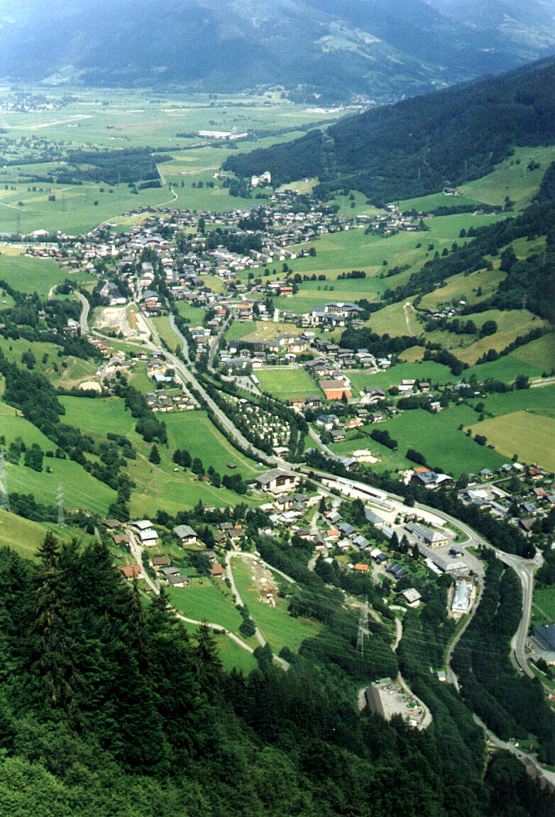
Fusch an der Großglocknerstraße is a picturesque village in Austria, nestled at the gateway to the Hohe Tauern National Park and near the famous Großglockner mountain, the highest peak in Austria. This area is a hiker's paradise, offering a variety of trails that cater to different skill levels, from leisurely walks to challenging alpine hikes.
Hiking Highlights
-
Scenic Trails: The region boasts stunning landscapes, including lush green valleys, rocky mountain terrain, and alpine meadows. Many trails provide breathtaking views of the Großglockner and surrounding peaks.
-
Großglockner High Alpine Road: While primarily a scenic drive, sections of the road offer access to several starting points for hikes, including the popular Pasterze Glacier trail, which allows hikers to get close to Austria's largest glacier.
-
Hohe Tauern National Park: This national park provides a vast network of hiking trails, wildlife viewing opportunities, and educational experiences about the local flora and fauna. Trail options range from easy walks to more strenuous hikes.
-
Zillertal Alps: Situated nearby, this mountain range offers routes leading to impressive viewpoints and the chance to experience alpine wildlife, such as chamois and marmots.
-
Local Trails: The area around Fusch has well-marked local trails, allowing you to explore charming alpine huts, traditional farms, and stunning vistas.
Practical Tips
- Weather Considerations: Weather in the mountains can change rapidly, so it’s important to check conditions before heading out and dress in layers.
- Safety: Always carry the essentials: water, snacks, a map, and a first aid kit. If you're hiking in remote areas, consider letting someone know your plans.
- Gear: Good hiking boots and trekking poles can enhance your experience, especially on uneven terrain.
- Guided Tours: If you’re not experienced or would like to learn more about the area, consider joining a guided hiking tour, which can add valuable insight and ensure safety.
Conclusion
Fusch an der Großglocknerstraße serves as an excellent base for exploring the stunning natural beauty of the Austrian Alps. Whether you're a novice hiker or an experienced mountaineer, the area offers memorable experiences amidst breathtaking scenery.
- Страна:

- Почтовый код: 5672
- Телефонный код: 06546
- Код автомобильного номера: ZE
- Координаты: 47° 13' 0" N, 12° 49' 0" E


- GPS треки (wikiloc): [Ссылка]
- Высота над уровнем моря: 815 м m
- Площадь: 158.06 кв.км
- Население: 719
- Веб сайт: http://www.fusch.at/
- Википедия русская: wiki(ru)
- Википедия английская: wiki(en)
- Википедия национальная: wiki(de)
- Хранилище Wikidata: Wikidata: Q694084
- Катеория в википедии: [Ссылка]
- код Freebase: [/m/02769pc]
- код GeoNames: Альт: [2779089]
- код VIAF: Альт: [243166153]
- идентификатор местоположения ArchINFORM: [10373]
- код австрийского муниципалитета: [50604]
Граничит с регионами:
Капрун
Hiking in Капрун
Kaprun, located in the Austrian Alps near the picturesque Lake Zell, is a fantastic destination for hiking enthusiasts. The area offers a diverse range of hiking trails suitable for all skill levels, from easy walks to more challenging alpine routes. Here's what you can expect when hiking in Kaprun:...
- Страна:
- Почтовый код: 5710
- Телефонный код: 06547
- Код автомобильного номера: ZE
- Координаты: 47° 16' 21" N, 12° 45' 34" E
- GPS треки (wikiloc): [Ссылка]
- Высота над уровнем моря: 786 м m
- Площадь: 100.41 кв.км
- Население: 3177
- Веб сайт: [Ссылка]

Брук-ан-дер-Гросглокнерштрассе
Hiking in Брук-ан-дер-Гросглокнерштрассе
Bruck an der Großglocknerstraße is a picturesque town located in the Austrian state of Salzburg, close to the stunning Hohe Tauern National Park. This area offers breathtaking landscapes, diverse flora and fauna, and a variety of hiking trails suitable for all levels of hikers....
- Страна:
- Телефонный код: 06545
- Код автомобильного номера: ZE
- Координаты: 47° 16' 0" N, 12° 49' 0" E
- GPS треки (wikiloc): [Ссылка]
- Высота над уровнем моря: 756 м m
- Площадь: 45.74 кв.км
- Население: 4699
- Веб сайт: [Ссылка]

Раурис
- муниципалитет в Австрии
Hiking in Раурис
Rauris is a beautiful valley located in the Hohe Tauern National Park in Austria, known for its stunning landscapes, rich flora and fauna, and excellent hiking opportunities. Here are some highlights:...
- Страна:
- Почтовый код: 5661
- Телефонный код: 06544
- Код автомобильного номера: ZE
- Координаты: 47° 8' 55" N, 12° 57' 22" E
- GPS треки (wikiloc): [Ссылка]
- Высота над уровнем моря: 1695 м m
- Площадь: 233.02 кв.км
- Население: 3044
- Веб сайт: [Ссылка]

Хайлигенблут
Hiking in Хайлигенблут
Heiligenblut am Großglockner is a picturesque village located in the Austrian Alps, known for its stunning landscapes and access to hiking trails around the Großglockner, Austria's highest mountain. Here are some key highlights for hiking in this beautiful region:...
- Страна:
- Почтовый код: 9844
- Телефонный код: 0 48 24
- Код автомобильного номера: SP
- Координаты: 47° 2' 29" N, 12° 50' 13" E
- GPS треки (wikiloc): [Ссылка]
- Высота над уровнем моря: 1288 м m
- Площадь: 193.5 кв.км
- Население: 1020
- Веб сайт: [Ссылка]