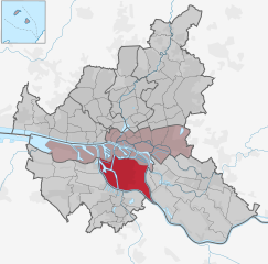
Хофштеттен-Грюнау (Hofstetten-Grünau, Hofstetten-Grünau)
 Hiking in Хофштеттен-Грюнау
Hofstetten-Grünau is a picturesque area located in the Emmental region of Switzerland. It offers a variety of hiking opportunities suitable for different levels of experience and fitness. Here are some key highlights for hiking in Hofstetten-Grünau:
Trails
-
Scenic Routes: The area features an array of trails that take you through beautiful landscapes, including rolling hills, lush forests, and charming Swiss farms. Many paths offer stunning views of the surrounding mountains and valleys.
-
Difficulty Levels: There are hiking trails for all skill levels, from easy, family-friendly routes to more challenging hikes that require a higher level of fitness and experience.
-
Marked Trails: The hiking routes are well-marked with signs indicating the distance and estimated time to complete each trail, making it easy to navigate the area.
Points of Interest
- Local Flora and Fauna: The region is rich in biodiversity, and you might encounter various wildlife and plant species along the trails.
- Cultural Landmarks: Some hikes may take you past historical sites, traditional Swiss architecture, and small villages where you can experience local culture.
Tips for Hiking in Hofstetten-Grünau
- Weather Preparedness: The weather can change quickly in the mountains, so it's important to check the forecast and be prepared for varying conditions. Dress in layers and bring appropriate gear.
- Hydration and Snacks: Carry enough water and light snacks to keep your energy up during the hike.
- Trail Etiquette: Be respectful of nature and other hikers. Stay on designated paths to protect the local ecosystem and follow the principles of Leave No Trace.
Getting There
Hofstetten-Grünau is accessible by public transport, with train and bus connections to nearby towns. If you are driving, check for parking options in the area.
Best Time to Hike
The optimal time for hiking in this region is typically between late spring and early autumn when the weather is mild, and the trails are accessible. Autumn can also provide stunning foliage views.
Whether you are looking for a serene walk through nature or a challenging hike with breathtaking views, Hofstetten-Grünau can offer a memorable outdoor experience. Always make sure to inform someone of your hiking plans and stay safe while enjoying the beautiful Swiss countryside!
- Страна:

- Почтовый код: 3202
- Телефонный код: 02723
- Код автомобильного номера: PL
- Координаты: 48° 5' 0" N, 15° 30' 0" E


- GPS треки (wikiloc): [Ссылка]
- Высота над уровнем моря: 317 м m
- Площадь: 35.93 кв.км
- Население: 2693
- Веб сайт: http://www.hofstetten-gruenau.at/
- Википедия русская: wiki(ru)
- Википедия английская: wiki(en)
- Википедия национальная: wiki(de)
- Хранилище Wikidata: Wikidata: Q674830
- Катеория в википедии: [Ссылка]
- код Freebase: [/m/02r5czq]
- код GeoNames: Альт: [7873012]
- код VIAF: Альт: [238146636]
- код австрийского муниципалитета: [31909]
Граничит с регионами:

Вильгельмсбург
- район в Гамбурге, Германия
Hiking in Вильгельмсбург
Wilhelmsburg, a district in Hamburg, Germany, is known for its unique blend of nature and urban life. While it may not be a traditional hiking destination like the Alps or national parks, there are still several opportunities for outdoor adventures and exploring scenic routes....
- Страна:

- Координаты: 53° 29' 42" N, 10° 0' 40" E
- GPS треки (wikiloc): [Ссылка]
- Высота над уровнем моря: -2 м m
- Площадь: 35.3 кв.км
Кильб
Hiking in Кильб
Kilb, also known as Kilb in Scottish Gaelic, is a beautiful location that offers various hiking opportunities, often surrounded by stunning natural landscapes. While specific trails may vary depending on the area, here are some general tips and highlights for hiking in Kilb:...
- Страна:
- Почтовый код: 3233
- Телефонный код: 02748
- Код автомобильного номера: ME
- Координаты: 48° 6' 0" N, 15° 24' 20" E
- GPS треки (wikiloc): [Ссылка]
- Высота над уровнем моря: 300 м m
- Площадь: 45.18 кв.км
- Население: 2543
- Веб сайт: [Ссылка]
Вайнбург
Hiking in Вайнбург
Weinburg, a picturesque area often associated with beautiful landscapes and scenic trails, offers a delightful experience for hikers of all levels. While I don't have specific details about a specific "Weinburg," if you are referring to general hiking in a region known for its vineyards and wine culture, here are some pointers that might help you plan your hike:...
- Страна:
- Почтовый код: 3205
- Телефонный код: 02747
- Код автомобильного номера: PL
- Координаты: 48° 6' 0" N, 15° 32' 0" E
- GPS треки (wikiloc): [Ссылка]
- Высота над уровнем моря: 321 м m
- Площадь: 10.36 кв.км
- Население: 1337
- Веб сайт: [Ссылка]

Рабенштайн-ан-дер-Пилах
Hiking in Рабенштайн-ан-дер-Пилах
Rabenstein an der Pielach is a charming village located in Lower Austria, surrounded by beautiful natural landscapes, making it an excellent destination for hiking enthusiasts. The area features various trails that cater to different skill levels, ranging from leisurely walks to more challenging hikes....
- Страна:
- Почтовый код: 3203
- Телефонный код: 02723
- Код автомобильного номера: PL
- Координаты: 48° 2' 0" N, 15° 28' 0" E
- GPS треки (wikiloc): [Ссылка]
- Высота над уровнем моря: 344 м m
- Площадь: 36.25 кв.км
- Население: 2560
- Веб сайт: [Ссылка]

Бишофштеттен
- коммуна в Австрии
Hiking in Бишофштеттен
Bischofstetten is a picturesque area located in Austria, surrounded by beautiful landscapes that make it a great destination for hiking enthusiasts. The region is characterized by rolling hills, lush forests, and charming meadows, offering various hiking trails suitable for different skill levels....
- Страна:
- Почтовый код: 3232
- Телефонный код: 02748
- Код автомобильного номера: ME
- Координаты: 48° 7' 24" N, 15° 28' 12" E
- GPS треки (wikiloc): [Ссылка]
- Высота над уровнем моря: 274 м m
- Площадь: 19 кв.км
- Население: 1176
- Веб сайт: [Ссылка]
Эшенау
Hiking in Эшенау
Eschenau, located in the scenic region of Bavaria, Germany, offers several hiking opportunities that highlight the area's natural beauty and cultural heritage....
- Страна:
- Почтовый код: 3153
- Телефонный код: 02762
- Код автомобильного номера: LF
- Координаты: 48° 2' 0" N, 15° 34' 0" E
- GPS треки (wikiloc): [Ссылка]
- Высота над уровнем моря: 406 м m
- Площадь: 24.71 кв.км
- Население: 1306
- Веб сайт: [Ссылка]