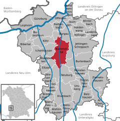
Ихенхаузен (Ichenhausen, Ichenhausen)

 Hiking in Ихенхаузен
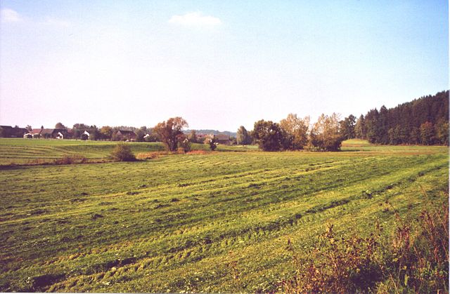
Ichenhausen, a charming town located in Bavaria, Germany, offers a variety of scenic hiking opportunities that are suitable for both beginners and experienced hikers. The region is characterized by its beautiful landscapes, including rolling hills, lush forests, and picturesque farmland.
Hiking Trails:
-
Local Trails: Many well-marked local trails start from the town center, allowing hikers to explore the area surrounding Ichenhausen. These trails often lead through scenic woodlands and offer great views of the countryside.
-
Donau-Wald Nature Park: Nearby, you can explore the Donau-Wald Nature Park, which features a network of trails that showcase the area's natural beauty, including river landscapes, diverse flora, and fauna.
-
Longer Routes: For those looking for more of a challenge, there are longer and more strenuous hikes in the Bavarian countryside, which can lead to nearby towns and historical sites.
Key Tips for Hiking in Ichenhausen:
- Prepare for Varied Weather: The weather can change quickly in Bavaria, so dress in layers and be prepared for both sun and rain.
- Stay Hydrated: Bring enough water, especially during warmer months.
- Local Guide: Consider joining a guided hiking group for diverse experiences and local insights about the trails and natural environment.
- Respect Nature: Always follow Leave No Trace principles to keep the trails and nature pristine.
Hiking Season:
Spring through fall is the best time for hiking in the Ichenhausen area, with vibrant flora and pleasant weather making for an enjoyable experience.
Whether you're seeking a peaceful walk through the woods or an adventurous trek through the hills, Ichenhausen has something to offer for every hiking enthusiast.
- Страна:

- Почтовый код: 89335
- Телефонный код: 08223
- Код автомобильного номера: GZ
- Координаты: 48° 22' 16" N, 10° 18' 25" E


- GPS треки (wikiloc): [Ссылка]
- Высота над уровнем моря: 492 м m
- Площадь: 34.22 кв.км
- Население: 7166
- Веб сайт: http://www.ichenhausen.de
- Википедия русская: wiki(ru)
- Википедия английская: wiki(en)
- Википедия национальная: wiki(de)
- Хранилище Wikidata: Wikidata: Q503202
- Катеория в википедии: [Ссылка]
- код Freebase: [/m/0fdrdc]
- код GeoNames: Альт: [2896776]
- код BNF: [12320328k]
- код VIAF: Альт: [137350128]
- ID отношения в OpenStreetMap: [964467]
- код GND: Альт: [4095880-2]
- код LCNAF: Альт: [n92097862]
- код темы Quora: [Ichenhausen]
- код Historical Gazetteer: [ICHSE1JN58DI]
- Bavarikon ID: [ODB_A00000666]
- идентификатор муниципалитетов в Германии: 09774143
Включает регионы:
Hochwang
Hiking in Hochwang
Hochwang, located near Ichenhausen in Bavaria, Germany, offers beautiful hiking opportunities in a picturesque natural setting. The mountain itself is part of the Allgäu Alps, providing stunning views and diverse landscapes....
- Страна:
- Координаты: 48° 23' 18" N, 10° 18' 32" E
- GPS треки (wikiloc): [Ссылка]
- Население: 1382
Граничит с регионами:

Каммельталь
Hiking in Каммельталь
Kammeltal, located in Bavaria, Germany, is a beautiful and serene area that offers various hiking opportunities for enthusiasts of all levels. The landscape is characterized by rolling hills, lush forests, and picturesque meadows, providing a scenic backdrop for outdoor adventures....
- Страна:
- Почтовый код: 89358
- Телефонный код: 08283; 08225; 08223; 08222
- Код автомобильного номера: GZ
- Координаты: 48° 23' 0" N, 10° 22' 0" E
- GPS треки (wikiloc): [Ссылка]
- Высота над уровнем моря: 468 м m
- Площадь: 41.74 кв.км
- Население: 3082
- Веб сайт: [Ссылка]


Кёц
Hiking in Кёц
Kötz, located in the district of Günzburg in Bavaria, Germany, is a charming area that offers various opportunities for hiking and enjoying nature. Here are some key points to consider when planning a hiking trip in Kötz:...
- Страна:
- Почтовый код: 89359
- Телефонный код: 08221
- Код автомобильного номера: GZ
- Координаты: 48° 25' 0" N, 10° 17' 0" E
- GPS треки (wikiloc): [Ссылка]
- Высота над уровнем моря: 475 м m
- Площадь: 20.55 кв.км
- Население: 2960
- Веб сайт: [Ссылка]

Пфаффенхофен-ан-дер-Рот
Hiking in Пфаффенхофен-ан-дер-Рот
Pfaffenhofen an der Roth, located in Bavaria, Germany, is surrounded by beautiful landscapes that make it an excellent spot for hiking enthusiasts. The region features a mix of forested pathways, rolling hills, and picturesque rural settings, ideal for hikers of all levels....
- Страна:
- Почтовый код: 89284
- Телефонный код: 07302
- Код автомобильного номера: ILL; NU
- Координаты: 48° 21' 16" N, 10° 9' 43" E
- GPS треки (wikiloc): [Ссылка]
- Высота над уровнем моря: 489 м m
- Площадь: 42.66 кв.км
- Население: 5897
- Веб сайт: [Ссылка]