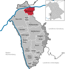
Пфаффенхофен-ан-дер-Рот (Pfaffenhofen an der Roth, Pfaffenhofen an der Roth)

 Hiking in Пфаффенхофен-ан-дер-Рот
Pfaffenhofen an der Roth, located in Bavaria, Germany, is surrounded by beautiful landscapes that make it an excellent spot for hiking enthusiasts. The region features a mix of forested pathways, rolling hills, and picturesque rural settings, ideal for hikers of all levels.
Hiking Trails
-
Local Trails: There are several marked hiking trails in and around Pfaffenhofen. These often take you through lush forests and fields, providing a serene experience in nature. Look for local signage that indicates routes suitable for various skill levels.
-
Roth Trail: The Roth River, which runs nearby, has trails that follow its banks. This area is particularly scenic and can be combined with longer hiking routes.
-
Nature Reserves: Nearby natural reserves may have designated hiking paths that offer unique flora and fauna, making your hike both enjoyable and educational.
Key Points
- Difficulty Levels: Trails around Pfaffenhofen range from easy to moderate, making them accessible for families and seasoned hikers alike.
- Length: Many trails can be completed in a few hours, while others may take most of the day. It’s advisable to check trail maps for distances before setting out.
- Seasonal Consideration: The best times for hiking in this area are typically spring through autumn, although winter hiking can also be beautiful, provided you have the right gear.
Tips
- Preparation: Always bring enough water, snacks, appropriate clothing, and a map or a GPS device to ensure a safe and enjoyable hike.
- Local Regulations: Be mindful of local wildlife and environmental guidelines. Stay on marked paths to protect natural habitats.
- Activities: Besides hiking, look out for opportunities for biking or birdwatching in the area.
Conclusion
Pfaffenhofen an der Roth offers a picturesque setting for hiking with a range of trails that cater to various hiking abilities. Whether you're looking for a leisurely stroll or a more challenging hike, this Bavarian locale can provide an incredible outdoor experience surrounded by nature.
- Страна:

- Почтовый код: 89284
- Телефонный код: 07302
- Код автомобильного номера: ILL; NU
- Координаты: 48° 21' 16" N, 10° 9' 43" E


- GPS треки (wikiloc): [Ссылка]
- Высота над уровнем моря: 489 м m
- Площадь: 42.66 кв.км
- Население: 5897
- Веб сайт: http://www.markt-pfaffenhofen.de
- Википедия русская: wiki(ru)
- Википедия английская: wiki(en)
- Википедия национальная: wiki(de)
- Хранилище Wikidata: Wikidata: Q628969
- Катеория в википедии: [Ссылка]
- код Freebase: [/m/099x3y]
- код GeoNames: Альт: [2854384]
- код VIAF: Альт: [146561980]
- ID отношения в OpenStreetMap: [941076]
- код GND: Альт: [4045444-7]
- код Historical Gazetteer: [PFAOTHJN58CI]
- Bavarikon ID: [ODB_A00000697]
- идентификатор муниципалитетов в Германии: 09775143
Граничит с регионами:
Stoffenrieder Forst
Hiking in Stoffenrieder Forst
Stoffenrieder Forst is a beautiful forested area located near Munich, Germany. It is known for its scenic landscapes, diverse flora and fauna, and well-maintained trails, making it a popular destination for both casual walkers and experienced hikers....
- Страна:
- Координаты: 48° 19' 0" N, 10° 14' 0" E
- GPS треки (wikiloc): [Ссылка]


Биберталь
Hiking in Биберталь
Bibertal is a beautiful region in Bavaria, Germany, known for its picturesque landscapes and variety of hiking trails. Here are some key points to consider when planning a hiking trip in this area:...
- Страна:
- Почтовый код: 89346
- Телефонный код: 08226
- Код автомобильного номера: GZ
- Координаты: 48° 24' 0" N, 10° 12' 0" E
- GPS треки (wikiloc): [Ссылка]
- Высота над уровнем моря: 495 м m
- Площадь: 27.31 кв.км
- Население: 4021
- Веб сайт: [Ссылка]


Ной-Ульм
- город в Германии
Hiking in Ной-Ульм
Neu-Ulm, located in Bavaria, Germany, sits along the banks of the Danube River and offers a variety of hiking opportunities in the surrounding areas. While the city itself is more urban, the nearby countryside and natural landscapes provide excellent options for outdoor exploration. Here are a few highlights related to hiking in and around Neu-Ulm:...
- Страна:
- Почтовый код: 89231
- Телефонный код: 0731; 07308; 07307
- Код автомобильного номера: NU
- Координаты: 48° 23' 0" N, 10° 0' 0" E
- GPS треки (wikiloc): [Ссылка]
- Высота над уровнем моря: 474 м m
- Площадь: 80.50 кв.км
- Население: 57727
- Веб сайт: [Ссылка]


Зенден
Hiking in Зенден
Senden, located in North Rhine-Westphalia, Germany, may not be widely recognized as a major hiking destination, but it offers several opportunities for outdoor enthusiasts to explore nature. Here are some aspects to consider when hiking in and around Senden:...
- Страна:
- Почтовый код: 89250
- Телефонный код: 07309; 07307
- Код автомобильного номера: NU
- Координаты: 48° 19' 0" N, 10° 4' 0" E
- GPS треки (wikiloc): [Ссылка]
- Высота над уровнем моря: 486 м m
- Площадь: 25.17 кв.км
- Население: 19010
- Веб сайт: [Ссылка]


Ихенхаузен
Hiking in Ихенхаузен
Ichenhausen, a charming town located in Bavaria, Germany, offers a variety of scenic hiking opportunities that are suitable for both beginners and experienced hikers. The region is characterized by its beautiful landscapes, including rolling hills, lush forests, and picturesque farmland....
- Страна:
- Почтовый код: 89335
- Телефонный код: 08223
- Код автомобильного номера: GZ
- Координаты: 48° 22' 16" N, 10° 18' 25" E
- GPS треки (wikiloc): [Ссылка]
- Высота над уровнем моря: 492 м m
- Площадь: 34.22 кв.км
- Население: 7166
- Веб сайт: [Ссылка]

Нерзинген
Hiking in Нерзинген
Nersingen is located in Bavaria, Germany, and is known for its beautiful landscapes and picturesque nature, making it a lovely spot for hiking enthusiasts. While there aren't extensive hiking trails specifically designated in Nersingen, you can find routes that connect to the surrounding areas, which offer a variety of hiking options....
- Страна:
- Почтовый код: 89278
- Телефонный код: 07308
- Код автомобильного номера: ILL; NU
- Координаты: 48° 25' 44" N, 10° 7' 19" E
- GPS треки (wikiloc): [Ссылка]
- Высота над уровнем моря: 465 м m
- Площадь: 24.28 кв.км
- Население: 9437
- Веб сайт: [Ссылка]


Вайсенхорн
- город Баварии
Hiking in Вайсенхорн
Weißenhorn is a picturesque town located in Bavaria, Germany, and it's known for its beautiful landscapes and access to various hiking trails. Hiking in and around Weißenhorn offers a chance to explore the scenic beauty of the Swabian region, with its rolling hills, forests, and farmlands. Here are some highlights to consider when hiking in Weißenhorn:...
- Страна:
- Почтовый код: 89264
- Телефонный код: 07306; 07309
- Код автомобильного номера: NU
- Координаты: 48° 18' 16" N, 10° 9' 33" E
- GPS треки (wikiloc): [Ссылка]
- Высота над уровнем моря: 501 м m
- Площадь: 53.69 кв.км
- Население: 13329
- Веб сайт: [Ссылка]


Хольцхайм
Hiking in Хольцхайм
Holzheim, located in the Neu-Ulm district of Germany, offers beautiful landscapes and opportunities for outdoor activities, including hiking. While it may not be widely known as a hiking destination, the region is characterized by scenic trails that can be enjoyed by both beginners and experienced hikers....
- Страна:
- Почтовый код: 89291
- Телефонный код: 07302
- Код автомобильного номера: ILL; NU
- Координаты: 48° 23' 0" N, 10° 6' 0" E
- GPS треки (wikiloc): [Ссылка]
- Высота над уровнем моря: 475 м m
- Площадь: 7.60 кв.км
- Население: 1455
- Веб сайт: [Ссылка]