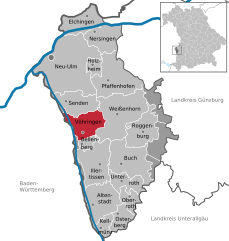
Иллерриден (Illerrieden, Illerrieden)

 Hiking in Иллерриден
Illerrieden is a charming village located in Bavaria, Germany, near the Iller River. The region offers a variety of hiking opportunities that can cater to different skill levels and preferences. Here are some points to consider if you're planning a hiking trip in Illerrieden:
Trails and Routes
-
Local Trails: Check out local hiking trails that wind through picturesque landscapes, including meadows, forests, and along the Iller River. The area boasts well-marked paths suitable for both beginners and experienced hikers.
-
Scenic Views: Many trails offer beautiful vistas of the surrounding hills and countryside, making it a great spot for photography and enjoying nature.
-
Nature Reserves: Explore nearby nature reserves where you can spot local wildlife and enjoy diverse flora. These areas often have dedicated walking paths.
Hiking Tips
- Preparation: Make sure to wear appropriate footwear and bring enough water and snacks. Weather can change quickly in the region, so bringing a waterproof jacket can be wise.
- Map and Navigation: Familiarize yourself with the area using maps or a hiking app for smartphones to ensure you stay on track.
- Local Guidance: If you're new to the area, consider joining a guided hike. Local guides can provide insights into the ecology and history of the region.
Nearby Attractions
- Cultural Sites: Illerrieden is close to other towns with historical and cultural sites worth visiting, such as Ulm with its famous Ulm Minster.
- Cycling: If you're interested in combining your hiking with cycling, there are also bike trails in the vicinity that offer a different perspective of the area.
Conclusion
Hiking in Illerrieden presents a great opportunity to immerse yourself in the scenic beauty of Bavaria. Whether you're looking for a leisurely walk along the river or a more challenging hike through the hills, this region offers something for everyone. Don't forget to check local resources for updated trail conditions and any events or guided hikes taking place during your visit. Enjoy your adventure!
- Страна:

- Почтовый код: 89186
- Телефонный код: 07306
- Код автомобильного номера: UL
- Координаты: 48° 16' 13" N, 10° 3' 6" E


- GPS треки (wikiloc): [Ссылка]
- Высота над уровнем моря: 500 м m
- Площадь: 18.17 кв.км
- Население: 3278
- Веб сайт: http://www.illerrieden.de
- Википедия русская: wiki(ru)
- Википедия английская: wiki(en)
- Википедия национальная: wiki(de)
- Хранилище Wikidata: Wikidata: Q515510
- Катеория в википедии: [Ссылка]
- код Freebase: [/m/02601kq]
- код GeoNames: Альт: [2896547]
- код VIAF: Альт: [238794200]
- ID отношения в OpenStreetMap: [2800692]
- код GND: Альт: [4786909-4]
- код Historical Gazetteer: [ILLDENJN58AG]
- идентификатор муниципалитетов в Германии: 08425066
Граничит с регионами:

Фёринген
Hiking in Фёринген
Vöhringen is a charming municipality located in Bavaria, Germany, offering various outdoor activities, including hiking. The region is characterized by its beautiful landscapes, including rolling hills, forests, and nearby rivers. Here are some highlights for hiking in and around Vöhringen:...
- Страна:
- Почтовый код: 89269
- Телефонный код: 07306
- Код автомобильного номера: NU
- Координаты: 48° 17' 0" N, 10° 5' 0" E
- GPS треки (wikiloc): [Ссылка]
- Высота над уровнем моря: 499 м m
- Площадь: 23.63 кв.км
- Население: 12168
- Веб сайт: [Ссылка]