Izon-la-Bruisse (Izon-la-Bruisse)

- коммуна во Франции
 Hiking in Izon-la-Bruisse
Izon-la-Bruisse is a beautiful destination located in the French Alps, known for its stunning landscapes, diverse flora and fauna, and well-marked hiking trails. Here are some highlights and tips for hiking in this region:
Trail Options
-
Les Gorges de la Méouge: This is a popular area that offers scenic views of the gorges and the river, making for a picturesque hike. The trails here are suitable for various skill levels, with options for both easy and moderate hikes.
-
Montagne de Lure: A bit further from Izon-la-Bruisse, this mountain provides spectacular views and trails that can range from easy walks to challenging hikes. The biodiversity in this area is remarkable, featuring rare plant species and wildlife.
-
The Veynes Loop: A moderately challenging loop that provides stunning alpine views and takes you through picturesque valleys. It’s a great way to experience the natural beauty of the region.
Best Times to Hike
The best time to hike in Izon-la-Bruisse is during the late spring through early autumn (May to October). Summer brings warmer temperatures and fully accessible trails. However, spring and autumn are great for enjoying the beauty of wildflowers and fall foliage, respectively.
Preparation Tips
- Trail Maps: Always carry a map or have a hiking app on your phone. Signage can be sparse in some areas.
- Clothing: Dress in layers to accommodate changing weather conditions, and wear sturdy, supportive hiking boots.
- Hydration & Snacks: Bring plenty of water and high-energy snacks, especially for longer hikes.
- Wildlife Awareness: Keep your distance from wildlife and never feed them.
- Local Regulations: Familiarize yourself with any local regulations or restrictions that may apply to hiking in the area.
Safety Considerations
- Always inform someone about your hiking plans, especially if you are venturing on less traveled paths.
- Check weather forecasts before heading out, as conditions can change rapidly in the mountains.
- Consider hiking with a buddy or group for added safety.
Attractions Nearby
After a day of hiking, you might want to explore local towns or relax in natural hot springs nearby. The region is also rich in history, so consider visiting some local historical sites when you have a day off from hiking.
Whether you're a novice hiker or an experienced adventurer, Izon-la-Bruisse offers a beautiful setting for enjoying nature and the outdoors. Happy hiking!
- Страна:

- Почтовый код: 26560
- Координаты: 44° 15' 20" N, 5° 35' 36" E


- GPS треки (wikiloc): [Ссылка]
- Площадь: 14.65 кв.км
- Население: 9
- Википедия английская: wiki(en)
- Википедия национальная: wiki(fr)
- Хранилище Wikidata: Wikidata: Q385291
- Катеория в википедии: [Ссылка]
- код Freebase: [/m/03mhgpg]
- код GeoNames: Альт: [6430101]
- номер SIREN: [212601504]
- код BNF: [15253011m]
- код VIAF: Альт: [240926697]
- код муниципалитета INSEE: 26150
Граничит с регионами:

Сент-Коломб
Hiking in Сент-Коломб
Sainte-Colombe, situated in the Hautes-Alpes region of France, is known for its stunning natural landscapes and diverse hiking trails, making it a great destination for outdoor enthusiasts. Here are some highlights and tips for hiking in the area:...
- Страна:
- Почтовый код: 05700
- Координаты: 44° 17' 5" N, 5° 40' 9" E
- GPS треки (wikiloc): [Ссылка]
- Высота над уровнем моря: 920 м m
- Площадь: 17.18 кв.км
- Население: 58

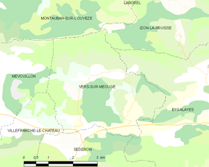
Vers-sur-Méouge
- коммуна во Франции
Hiking in Vers-sur-Méouge
Vers-sur-Méouge is a charming village located in the Drôme department in southeastern France, known for its natural beauty and outdoor activities, particularly hiking. The surrounding region features stunning landscapes, including the picturesque Méouge River, limestone cliffs, and the scenic backdrop of the Baronnies Provençales Natural Regional Park....
- Страна:
- Почтовый код: 26560
- Координаты: 44° 13' 51" N, 5° 34' 14" E
- GPS треки (wikiloc): [Ссылка]
- Площадь: 13.81 кв.км
- Население: 47


Montauban-sur-l'Ouvèze
- коммуна во Франции
Hiking in Montauban-sur-l'Ouvèze
Montauban-sur-l'Ouvèze is a charming village located in the Drôme department in southeastern France, nestled in the picturesque region of the Vercors. The area is known for its stunning natural landscapes, making it a great destination for hiking enthusiasts....
- Страна:
- Почтовый код: 26170
- Координаты: 44° 16' 28" N, 5° 30' 8" E
- GPS треки (wikiloc): [Ссылка]
- Площадь: 32.29 кв.км
- Население: 107


Ballons
- коммуна во Франции
Hiking in Ballons
Hiking in the Ballons des Vosges Regional Nature Park, located in northeastern France, offers a diverse range of trails and stunning landscapes. The park is characterized by its rolling hills, mountainous terrain, and dense forests, making it a fantastic destination for both novice and experienced hikers....
- Страна:
- Почтовый код: 26560
- Координаты: 44° 15' 21" N, 5° 38' 39" E
- GPS треки (wikiloc): [Ссылка]
- Площадь: 17.23 кв.км
- Население: 83

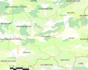
Eygalayes
- коммуна во Франции
Hiking in Eygalayes
Eygaliers is a picturesque village in the Drôme department of southeastern France, nestled in the beautiful landscape of the Vercors Regional Natural Park. It offers a variety of hiking opportunities that cater to all levels of experience. Here’s a general overview of hiking in the Eygaliers area:...
- Страна:
- Почтовый код: 26560
- Координаты: 44° 14' 21" N, 5° 36' 28" E
- GPS треки (wikiloc): [Ссылка]
- Площадь: 17.97 кв.км
- Население: 76
- Веб сайт: [Ссылка]


Laborel
- коммуна во Франции
Hiking in Laborel
Laborel is a small and picturesque village located in the Drôme department of southeastern France. It's nestled in the charming landscape of the Vercors Regional Natural Park, which offers a range of hiking opportunities for both beginners and experienced hikers....
- Страна:
- Почтовый код: 26560
- Координаты: 44° 17' 32" N, 5° 35' 45" E
- GPS треки (wikiloc): [Ссылка]
- Площадь: 23.91 кв.км
- Население: 106