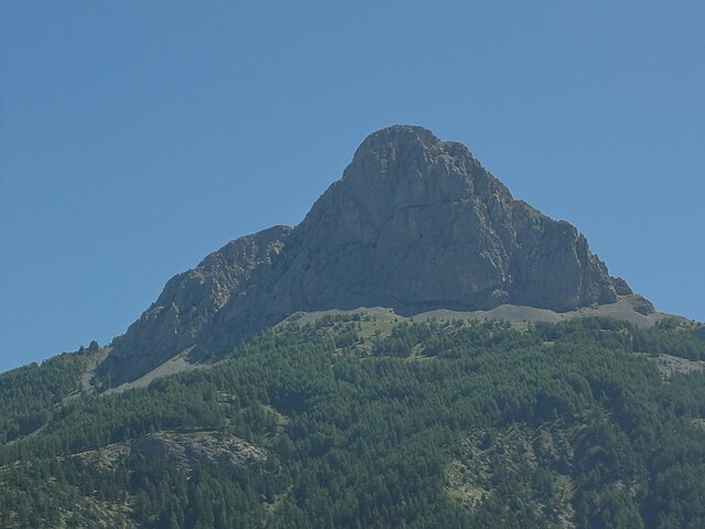
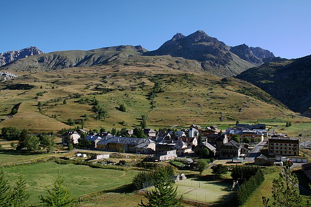
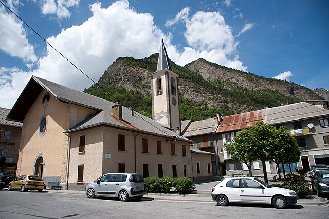
Жозье (Jausiers, Jausiers)
- коммуна во Франции
 Hiking in Жозье
Jausiers is a charming village located in the Alpes-de-Haute-Provence region of France. It's nestled in the heart of the French Alps and offers attractive hiking opportunities for outdoor enthusiasts. Here are some highlights about hiking in and around Jausiers:
Scenic Trails:
-
Col de la Bonette: This renowned mountain pass offers an exhilarating hiking experience. The hike up to the summit provides stunning panoramic views of the surrounding peaks and valleys.
-
Lac de l’Allos: A beautiful hike that leads to the largest natural lake in France. The trail offers a mix of stunning landscapes, wildlife, and one of the best spots for a picturesque picnic.
-
Le Queyras Regional Natural Park: Just a short drive from Jausiers, this park features a variety of trails ranging from easy walks to challenging treks. Immerse yourself in the pristine alpine environment.
Difficulty Levels:
Jausiers caters to all levels of hikers:
- Beginner Trails: Gentle paths around the village and to nearby viewpoints are great for families and beginners.
- Intermediate Trails: Moderate hikes that may include some elevation gain, suitable for those with a bit more hiking experience.
- Advanced Trails: For seasoned hikers looking for challenging terrain, the higher-altitude trails will test your endurance and provide breathtaking views.
Wildlife and Flora:
The region is rich in biodiversity. Live sightings of ibex, marmots, and various bird species are common, especially in the higher elevations. The flora varies by altitude, with lush meadows filled with wildflowers in the warmer months.
Best Time to Hike:
- Summer (June to September): This is the peak hiking season, with warmer temperatures and accessible trails.
- Autumn (September to October): A beautiful time for hiking as the foliage changes; fewer crowds and moderate weather conditions.
- Winter: Some trails may be suitable for snowshoeing or winter hiking, but it’s essential to check conditions and go with proper gear.
Preparation Tips:
- Always check the weather before heading out; conditions can change rapidly in the mountains.
- Proper footwear is critical; sturdy hiking boots provide the necessary support and traction.
- Carry plenty of water, snacks, and a first-aid kit.
- Consult local maps and guides or consider hiring a local guide for more challenging routes.
Local Resources:
- Tourist information centers in Jausiers can provide maps, advice, and guided tour options.
- Consider local accommodations that cater to hikers, offering early breakfasts and packed lunches for your adventures.
Whether you are interested in leisurely strolls or challenging treks, the stunning environment and the natural beauty around Jausiers make it an excellent destination for hiking enthusiasts!
- Страна:

- Почтовый код: 04850
- Координаты: 44° 25' 4" N, 6° 43' 50" E


- GPS треки (wikiloc): [Ссылка]
- Площадь: 107.73 кв.км
- Население: 1133
- Веб сайт: http://www.jausiers.com/
- Википедия русская: wiki(ru)
- Википедия английская: wiki(en)
- Википедия национальная: wiki(fr)
- Хранилище Wikidata: Wikidata: Q217065
- Галерея изображений в википедии: [Ссылка]
- Катеория в википедии: [Ссылка]
- код Freebase: [/m/03m7wqv]
- код Freebase: [/m/03m7wqv]
- код GeoNames: Альт: [3012406]
- код GeoNames: Альт: [3012406]
- номер SIREN: [210400966]
- номер SIREN: [210400966]
- код VIAF: Альт: [134930085]
- код VIAF: Альт: [134930085]
- код LCNAF: Альт: [n85081638]
- код LCNAF: Альт: [n85081638]
- код тезауруса PACTOLS: [pcrthjdDhIcSOQ]
- код тезауруса PACTOLS: [pcrthjdDhIcSOQ]
- код муниципалитета INSEE: 04096
- код муниципалитета INSEE: 04096
Граничит с регионами:
Юверне-Фур
- коммуна во Франции
Hiking in Юверне-Фур
Uvernet-Fours is a charming destination in the French Alpes-de-Haute-Provence region, known for its beautiful landscapes and outdoor recreational opportunities, including hiking. Here are some details to help you plan your hiking experience in this area:...
- Страна:
- Почтовый код: 04400
- Координаты: 44° 21' 40" N, 6° 37' 34" E
- GPS треки (wikiloc): [Ссылка]
- Площадь: 135.44 кв.км
- Население: 583

Аншастрей
- коммуна во Франции
Hiking in Аншастрей
Enchastrayes is a stunning area located in the French Alps, near the town of Barcelonnette in the Alpes-de-Haute-Provence region. This area is known for its beautiful landscapes, diverse flora and fauna, and a variety of hiking trails suitable for different skill levels....
- Страна:
- Почтовый код: 04400
- Координаты: 44° 22' 3" N, 6° 41' 43" E
- GPS треки (wikiloc): [Ссылка]
- Площадь: 44.19 кв.км
- Население: 391

Мейрон
- коммуна во Франции
Hiking in Мейрон
Meyronnes is a picturesque village located in the Alpes-de-Haute-Provence region of southeastern France. Nestled in the Mercantour National Park, it offers a range of hiking opportunities that cater to different skill levels, making it an excellent destination for nature lovers and outdoor enthusiasts....
- Страна:
- Почтовый код: 04530
- Координаты: 44° 28' 35" N, 6° 47' 57" E
- GPS треки (wikiloc): [Ссылка]
- Площадь: 40.59 кв.км
- Население: 60
Ларш
- коммуна во Франции
Hiking in Ларш
L'Arche, located in the Alpes-de-Haute-Provence region of France, is a fantastic destination for hiking enthusiasts. The area is characterized by its stunning landscapes, varied terrain, and the rich natural beauty of the French Alps. Here are some key highlights about hiking in Larche:...
- Страна:
- Почтовый код: 04540
- Координаты: 44° 27' 5" N, 6° 50' 48" E
- GPS треки (wikiloc): [Ссылка]
- Площадь: 68.86 кв.км
- Население: 55

Фокон-де-Барселоннет
- коммуна во Франции
Hiking in Фокон-де-Барселоннет
Faucon-de-Barcelonnette is a charming village located in the Alpes-de-Haute-Provence region of France, surrounded by stunning landscapes that are perfect for hiking enthusiasts. The area features a variety of trails suitable for different skill levels, ranging from easy walks to more challenging treks, making it an excellent destination for hikers of all experiences....
- Страна:
- Почтовый код: 04400
- Координаты: 44° 23' 37" N, 6° 40' 42" E
- GPS треки (wikiloc): [Ссылка]
- Площадь: 17.42 кв.км
- Население: 303
- Веб сайт: [Ссылка]
Ла-Кондамин-Шатлар
- коммуна во Франции
Hiking in Ла-Кондамин-Шатлар
La Condamine-Châtelard is a picturesque village located in the Alpes-Maritimes region of France, near the Italian border. It's a part of the larger area of the French Alps, known for its stunning natural landscapes and outdoor recreational opportunities, including hiking....
- Страна:
- Почтовый код: 04530
- Координаты: 44° 27' 29" N, 6° 44' 45" E
- GPS треки (wikiloc): [Ссылка]
- Высота над уровнем моря: 1305 м m
- Площадь: 56.08 кв.км
- Население: 172

Сен-Дальма-ле-Сельваж
- коммуна в департаменте Приморские Альпы, регион Прованс — Альпы — Лазурный Берег, Франция
Hiking in Сен-Дальма-ле-Сельваж
Saint-Dalmas-le-Selvage is a beautiful village located in the Alpes-Maritimes department in southeastern France, known for its stunning mountain scenery and access to numerous hiking trails. Here are some highlights and tips for hiking in the area:...
- Страна:
- Почтовый код: 06660
- Координаты: 44° 17' 5" N, 6° 51' 58" E
- GPS треки (wikiloc): [Ссылка]
- Площадь: 81.03 кв.км
- Население: 122

Сент-Этьен-де-Тине
- коммуна в департаменте Приморские Альпы, регион Прованс — Альпы — Лазурный Берег, Франция
Hiking in Сент-Этьен-де-Тине
Saint-Étienne-de-Tinée is a charming village located in the Alpes-Maritimes region of southeastern France, nestled in the Tinée Valley. It serves as a great base for hikers looking to explore the stunning natural landscapes of the surrounding area, including the Mercantour National Park, which is renowned for its dramatic scenery and diverse wildlife....
- Страна:
- Почтовый код: 06660
- Координаты: 44° 15' 25" N, 6° 55' 29" E
- GPS треки (wikiloc): [Ссылка]
- Высота над уровнем моря: 1139 м m
- Площадь: 173.81 кв.км
- Население: 1468