.jpg)
Кюснахт-ам-Риги (Küssnacht, Küssnacht)

 Hiking in Кюснахт-ам-Риги
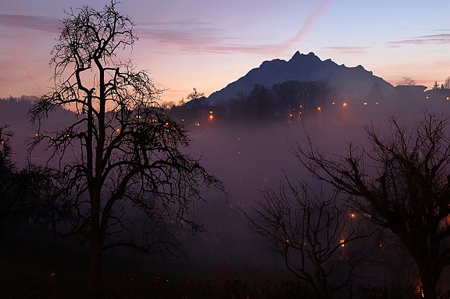
Küssnacht, located in the picturesque Swiss region of Central Switzerland, offers a variety of hiking trails that cater to different skill levels, making it a great destination for hikers. Nestled along the shores of Lake Zug and near Mount Rigi, the area provides stunning views and diverse landscapes. Here are some highlights of hiking in and around Küssnacht:
Hiking Trails
-
Küssnacht to Rigi: One popular hike is to ascend to Rigi, often called the "Queen of Mountains." The hike from Küssnacht to Rigi offers breathtaking views of the surrounding mountains and lakes. The trail is well-marked and features a mix of forest paths and open meadows.
-
Seebodenalp: This hike leads you to Seebodenalp, a scenic plateau above the lake, which offers panoramic views of the area. It's accessible for families and beginners and is great for a leisurely day out.
-
Schwyz Region Trails: Just a short distance from Küssnacht, the Schwyz region has many marked trails, ranging from easy walks to challenging mountain hikes. The trails often showcase beautiful landscapes, traditional Swiss farms, and offer great opportunities for photography.
-
Forest Trails: The area surrounding Küssnacht has several forest paths ideal for nature lovers. These trails are relatively easy and great for a peaceful hike amidst nature.
Tips for Hiking in Küssnacht
-
Preparation: Always check the weather forecast before heading out, as conditions can change rapidly in the mountains. Dress in layers and wear appropriate footwear.
-
Local Maps: Make sure to have a local hiking map or use a hiking app to navigate the trails comfortably. The trails are well-signposted, but it’s always good to have a backup.
-
Stay Hydrated and Nourished: Carry enough water and snacks, particularly on longer hikes. There may be limited opportunities to buy refreshments on the trails.
-
Respect Nature: Follow Leave No Trace principles. Stay on marked trails, respect wildlife, and pack out all waste.
-
Public Transport: Küssnacht is accessible by train and bus, making it easy to start your hike from nearby towns or return after a long day in the mountains.
Conclusion
Küssnacht is a wonderful destination for hiking enthusiasts, offering a mix of scenic views, well-maintained trails, and opportunities to immerse oneself in nature. Whether you're looking for an easy stroll or a challenging climb, you will find something that suits your preference in this beautiful Swiss region. Happy hiking!
- Страна:

- Почтовый код: 6403
- Телефонный код: 041
- Код автомобильного номера: SZ
- Координаты: 47° 4' 58" N, 8° 26' 27" E


- GPS треки (wikiloc): [Ссылка]
- Высота над уровнем моря: 445 м m
- Площадь: 36.2 кв.км
- Население: 12845
- Веб сайт: http://www.kuessnacht.ch
- Википедия русская: wiki(ru)
- Википедия английская: wiki(en)
- Википедия национальная: wiki(de)
- Хранилище Wikidata: Wikidata: Q64183
- Катеория в википедии: [Ссылка]
- код Freebase: [/m/06_b41]
- код GeoNames: Альт: [7286230]
- код BNF: [151905159]
- код VIAF: Альт: [136158111]
- ID отношения в OpenStreetMap: [1683087]
- код GND: Альт: [4098793-0]
- идентификатор местоположения ArchINFORM: [15643]
- место в MusicBrainz: [d2ff6985-fec7-4af6-a266-17ddec819b75]
- WOEID: [782960]
- код TGN: [1064133]
- идентификатор HDS: [715]
- код швейцарского муниципалитета: [1331]
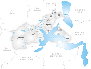
Граничит с регионами:

Адлигенсвиль
Hiking in Адлигенсвиль
Adligenswil is a charming municipality located near Lucerne, Switzerland, and offers a variety of hiking opportunities that cater to different skill levels. The region is characterized by its stunning natural landscapes, including rolling hills, forests, and views of Lake Lucerne and the surrounding mountains....
- Страна:
- Почтовый код: 6043
- Телефонный код: 041
- Код автомобильного номера: LU
- Координаты: 47° 4' 20" N, 8° 22' 6" E
- GPS треки (wikiloc): [Ссылка]
- Высота над уровнем моря: 569 м m
- Площадь: 6.99 кв.км
- Население: 5343
- Веб сайт: [Ссылка]

Греппен
- Коммуна в Швейцарии, в кантоне Люцерн.
Hiking in Греппен
Greppen is a picturesque village located in the Canton of Lucerne, Switzerland, nestled along the shores of Lake Zug and surrounded by stunning natural landscapes. It's an excellent destination for hiking enthusiasts of all skill levels, offering a variety of trails that showcase the area's breathtaking views, lush forests, and charming countryside....
- Страна:
- Почтовый код: 6404
- Телефонный код: 041
- Код автомобильного номера: LU
- Координаты: 47° 3' 18" N, 8° 25' 46" E
- GPS треки (wikiloc): [Ссылка]
- Высота над уровнем моря: 449 м m
- Площадь: 5.25 кв.км
- Население: 1075
- Веб сайт: [Ссылка]


Мегген
Hiking in Мегген
Meggen is a picturesque village located in the Canton of Lucerne in Switzerland, offering stunning views over Lake Lucerne and the surrounding mountains. Here are some aspects of hiking in and around Meggen that you might find interesting:...
- Страна:
- Почтовый код: 6045
- Телефонный код: 041
- Код автомобильного номера: LU
- Координаты: 47° 2' 47" N, 8° 22' 28" E
- GPS треки (wikiloc): [Ссылка]
- Высота над уровнем моря: 479 м m
- Площадь: 13.93 кв.км
- Население: 7138
- Веб сайт: [Ссылка]


Майерскаппель
Hiking in Майерскаппель
Meierskappel is a picturesque village located in the canton of Lucerne, Switzerland, which offers a variety of hiking opportunities amidst beautiful landscapes. The area is characterized by its rolling hills, lush forests, and stunning views of the surrounding mountains and the nearby Lake Lucerne....
- Страна:
- Почтовый код: 6344
- Телефонный код: 041
- Код автомобильного номера: LU
- Координаты: 47° 7' 32" N, 8° 26' 39" E
- GPS треки (wikiloc): [Ссылка]
- Высота над уровнем моря: 487 м m
- Площадь: 9.23 кв.км
- Население: 1369
- Веб сайт: [Ссылка]


Удлигенсвиль
Hiking in Удлигенсвиль
Udligenswil is a charming municipality located in the canton of Lucerne, Switzerland, surrounded by beautiful landscapes and scenic views. Hiking in this region can be a delightful experience, as it offers a mix of easy walks and more challenging trails suitable for various skill levels....
- Страна:
- Почтовый код: 6044
- Телефонный код: 041
- Код автомобильного номера: LU
- Координаты: 47° 5' 28" N, 8° 23' 59" E
- GPS треки (wikiloc): [Ссылка]
- Высота над уровнем моря: 624 м m
- Площадь: 6.25 кв.км
- Население: 2279
- Веб сайт: [Ссылка]


Веггис
Hiking in Веггис
Weggis is a charming lakeside village located in the Canton of Lucerne in Switzerland, nestled along the shores of Lake Lucerne and surrounded by stunning mountains. It is an excellent starting point for hiking enthusiasts due to its diverse range of trails and breathtaking scenery. Here are some highlights of hiking in Weggis:...
- Страна:
- Почтовый код: 6353
- Телефонный код: 041
- Код автомобильного номера: LU
- Координаты: 47° 2' 14" N, 8° 26' 34" E
- GPS треки (wikiloc): [Ссылка]
- Высота над уровнем моря: 582 м m
- Площадь: 25.29 кв.км
- Население: 4404
- Веб сайт: [Ссылка]

Вальхвиль
- коммуна в Швейцарии
Hiking in Вальхвиль
Walchwil is a picturesque village located in the Canton of Zug in Switzerland, situated on the shores of Lake Zug. It offers a range of hiking opportunities, making it an excellent destination for both casual walkers and seasoned hikers. Here are some highlights and tips for hiking in and around Walchwil:...
- Страна:
- Почтовый код: 6318
- Телефонный код: 041
- Код автомобильного номера: ZG
- Координаты: 47° 6' 31" N, 8° 31' 57" E
- GPS треки (wikiloc): [Ссылка]
- Высота над уровнем моря: 942 м m
- Площадь: 15.9 кв.км
- Население: 3617
- Веб сайт: [Ссылка]


Арт
Hiking in Арт
Arth, located in the Swiss Alps, offers stunning landscapes and a variety of hiking opportunities for outdoor enthusiasts. Here are some key points about hiking in the Arth region:...
- Страна:
- Почтовый код: 6415
- Телефонный код: 041
- Код автомобильного номера: SZ
- Координаты: 47° 3' 52" N, 8° 31' 27" E
- GPS треки (wikiloc): [Ссылка]
- Высота над уровнем моря: 422 м m
- Площадь: 48.50 кв.км
- Население: 11877
- Веб сайт: [Ссылка]