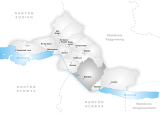
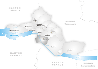
Кальтбрун (Kaltbrunn, Kaltbrunn)

 Hiking in Кальтбрун
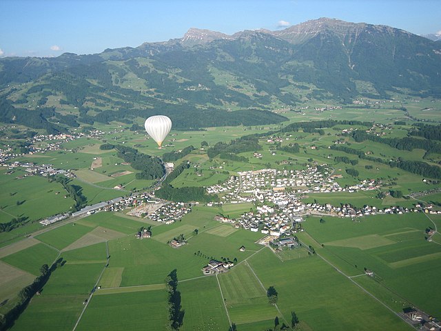
Kaltbrunn, located in the beautiful region of Switzerland, offers a delightful experience for hikers of various skill levels. This picturesque area is surrounded by stunning landscapes, including rolling hills, lush forests, and scenic views of the nearby mountains.
Hiking Trails
-
Kaltbrunn to Rothenthurm: This moderate hike takes you through serene countryside and charming villages. The path meanders through forests and fields, making it ideal for nature lovers.
-
Hiking around the Zurich Oberland: Kaltbrunn serves as a good starting point for exploring the broader Zurich Oberland region, which boasts a plethora of marked trails varying in difficulty.
-
Kaltbrunn Panorama Trail: This trail offers breathtaking views of the surrounding mountains and, on clear days, you can even see Lake Zurich in the distance. It’s perfect for those looking to enjoy a leisurely hike while taking in the stunning scenery.
Best Time to Visit
The best time for hiking in Kaltbrunn is during the late spring to early fall (May to September) when the weather is generally mild and the trails are well-maintained. In winter, while some trails may be accessible, be prepared for snow and colder conditions.
Essential Tips
- Footwear: Make sure to wear sturdy hiking boots suitable for various terrains.
- Weather: Check the weather forecast before heading out, as conditions can change rapidly in the mountains.
- Hydration: Carry enough water, especially on longer hikes.
- Navigation: Familiarize yourself with the trail maps and have a GPS device or app handy.
- Wildlife: Respect local wildlife and follow any guidelines set by local authorities.
Local Amenities
Kaltbrunn has a few amenities, including small shops and possibly local guesthouses where you can replenish your supplies or stay overnight if you plan on a longer hiking excursion.
Whether you're an experienced hiker or just starting out, Kaltbrunn provides a beautiful backdrop for an enjoyable hiking adventure. Happy hiking!
- Страна:

- Почтовый код: 8722
- Телефонный код: 055
- Код автомобильного номера: SG
- Координаты: 47° 12' 59" N, 9° 2' 0" E


- GPS треки (wikiloc): [Ссылка]
- Высота над уровнем моря: 441 м m
- Площадь: 18.68 кв.км
- Население: 4798
- Веб сайт: http://www.kaltbrunn.ch
- Википедия русская: wiki(ru)
- Википедия английская: wiki(en)
- Википедия национальная: wiki(de)
- Хранилище Wikidata: Wikidata: Q66786
- Катеория в википедии: [Ссылка]
- код Freebase: [/m/0f88fd]
- код GeoNames: Альт: [2660194]
- код VIAF: Альт: [239232071]
- ID отношения в OpenStreetMap: [1683899]
- код GND: Альт: [7576165-8]
- идентификатор HDS: [1362]
- код швейцарского муниципалитета: [3313]
Граничит с регионами:

Шенис
Hiking in Шенис
Schänis is a charming municipality located in the canton of St. Gallen, Switzerland. It's a great area for hiking enthusiasts, offering a variety of trails that cater to different skill levels, along with stunning natural vistas....
- Страна:
- Почтовый код: 8718
- Телефонный код: 055
- Код автомобильного номера: SG
- Координаты: 47° 9' 32" N, 9° 2' 48" E
- GPS треки (wikiloc): [Ссылка]
- Высота над уровнем моря: 683 м m
- Площадь: 39.90 кв.км
- Население: 3812
- Веб сайт: [Ссылка]


Эбнат-Каппель
Hiking in Эбнат-Каппель
Ebnat-Kappel, located in the canton of St. Gallen in Switzerland, is a wonderful destination for hiking enthusiasts. Nestled at the foot of the impressive Alpstein massif, this picturesque Swiss village offers a variety of trails that cater to different skill levels, making it accessible for both casual walkers and more experienced hikers....
- Страна:
- Почтовый код: 9642
- Телефонный код: 071
- Код автомобильного номера: SG
- Координаты: 47° 15' 48" N, 9° 7' 24" E
- GPS треки (wikiloc): [Ссылка]
- Высота над уровнем моря: 630 м m
- Площадь: 43.57 кв.км
- Население: 5012
- Веб сайт: [Ссылка]


Гоммисвальд
Hiking in Гоммисвальд
Gommiswald is a charming village located in the canton of St. Gallen, Switzerland. It's an excellent starting point for hikers looking to explore the natural beauty of the region, with a variety of trails suitable for different skill levels. Here are some highlights about hiking in Gommiswald:...
- Страна:
- Почтовый код: 8737
- Телефонный код: 055
- Код автомобильного номера: SG
- Координаты: 47° 14' 26" N, 9° 2' 51" E
- GPS треки (wikiloc): [Ссылка]
- Высота над уровнем моря: 1074 м m
- Площадь: 33.59 кв.км
- Население: 5053
- Веб сайт: [Ссылка]


Уцнах
Hiking in Уцнах
Uznach is a charming village located in the canton of St. Gallen in Switzerland, surrounded by beautiful landscapes, making it an excellent destination for hiking enthusiasts. Here are some highlights and tips for hiking in the Uznach area:...
- Страна:
- Почтовый код: 8730
- Телефонный код: 055
- Код автомобильного номера: SG
- Координаты: 47° 13' 36" N, 8° 58' 53" E
- GPS треки (wikiloc): [Ссылка]
- Высота над уровнем моря: 417 м m
- Площадь: 7.55 кв.км
- Население: 6336
- Веб сайт: [Ссылка]
Бенкен
Hiking in Бенкен
Benken, located in the canton of St. Gallen, Switzerland, offers a variety of hiking opportunities that showcase the stunning landscapes and natural beauty of the region. The area is characterized by rolling hills, lush forests, and panoramic views of the Alps, making it a delightful destination for outdoor enthusiasts....
- Страна:
- Почтовый код: 8717
- Телефонный код: 055
- Код автомобильного номера: SG
- Координаты: 47° 11' 59" N, 9° 1' 0" E
- GPS треки (wikiloc): [Ссылка]
- Высота над уровнем моря: 420 м m
- Площадь: 16.48 кв.км
- Население: 3015
- Веб сайт: [Ссылка]