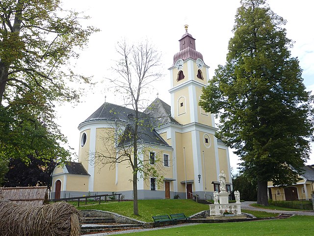
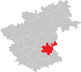
Коттес-Пурк (Kottes-Purk, Kottes-Purk)
 Hiking in Коттес-Пурк
Kottes-Purk is a small municipality located in the province of Lower Austria, Austria. While it may not be as famous as some larger hiking destinations, it offers a quaint environment for nature lovers and hikers.
Hiking Opportunities in Kottes-Purk:
-
Scenic Trails: The area is characterized by beautiful landscapes, including forests, hills, and rural fields. You can find several well-marked trails suitable for different skill levels.
-
Nature Experience: Hiking in this region allows you to immerse yourself in nature. You may encounter local wildlife and enjoy the serene surroundings that provide an escape from urban life.
-
Nearby Attractions: If you’re looking to expand your hiking experience, the surrounding regions of Lower Austria, such as the Waldviertel or the Vienna Woods, offer extensive trails ranging from easy walks to challenging hikes.
-
Cultural Sites: Along the hiking trails, you might come across historical sites, traditional farms, and quaint villages that allow you to experience local culture and hospitality.
-
Seasonal Considerations: The best times to hike are typically late spring through early fall when the weather is mild and the trails are accessible. Snow might affect trail conditions in winter.
Tips for Hiking in Kottes-Purk:
- Stay Hydrated: Always carry enough water, especially during warmer months.
- Appropriate Gear: Wear comfortable hiking shoes and dress in layers to adjust to changing weather conditions.
- Navigation: While trails are marked, having a map or a GPS device can enhance your experience and help prevent getting lost.
- Respect Nature: Follow Leave No Trace principles, ensuring you carry out all your waste and minimize your impact on the environment.
If Kottes-Purk is your destination, it can provide a peaceful hiking experience typical of the Austrian countryside!
- Страна:

- Телефонный код: 02873
- Код автомобильного номера: ZT
- Координаты: 48° 25' 0" N, 15° 18' 0" E


- GPS треки (wikiloc): [Ссылка]
- Высота над уровнем моря: 706 м m
- Площадь: 58.61 кв.км
- Население: 1485
- Веб сайт: http://www.kottes-purk.at/
- Википедия русская: wiki(ru)
- Википедия английская: wiki(en)
- Википедия национальная: wiki(de)
- Хранилище Wikidata: Wikidata: Q691693
- Катеория в википедии: [Ссылка]
- код Freebase: [/m/03gslhm]
- код GeoNames: Альт: [7873085]
- код VIAF: Альт: [237475690]
- идентификатор местоположения ArchINFORM: [10066]
- код австрийского муниципалитета: [32515]
Граничит с регионами:

Вайнцирль-на-Вальде
Hiking in Вайнцирль-на-Вальде
Weinzierl am Walde, nestled in the picturesque region of Austria, offers a variety of hiking opportunities that cater to both beginners and experienced hikers. Here’s what you can expect when hiking in this area:...
- Страна:
- Почтовый код: 3521
- Телефонный код: 02717
- Код автомобильного номера: KR
- Координаты: 48° 25' 0" N, 15° 26' 0" E
- GPS треки (wikiloc): [Ссылка]
- Высота над уровнем моря: 647 м m
- Площадь: 44.55 кв.км
- Население: 1240
- Веб сайт: [Ссылка]

Альбрехтсберг-ан-дер-Гроссен-Кремс
Hiking in Альбрехтсберг-ан-дер-Гроссен-Кремс
Albrechtsberg an der Großen Krems is a charming village located in the picturesque Wachau Valley of Austria, known for its rich cultural heritage, beautiful landscapes, and excellent hiking opportunities. Here’s a guide to hiking in the area:...
- Страна:
- Почтовый код: 3613
- Телефонный код: 02876
- Код автомобильного номера: KR
- Координаты: 48° 27' 50" N, 15° 22' 8" E
- GPS треки (wikiloc): [Ссылка]
- Высота над уровнем моря: 686 м m
- Площадь: 28.72 кв.км
- Население: 1036
- Веб сайт: [Ссылка]
Раксендорф
Hiking in Раксендорф
Raxendorf is a picturesque village located in the Austrian province of Lower Austria, known for its stunning natural landscapes and hiking opportunities. The area is characterized by lush forests, rolling hills, and scenic views, making it an excellent destination for outdoor enthusiasts....
- Страна:
- Почтовый код: 3654
- Телефонный код: 02758
- Код автомобильного номера: ME
- Координаты: 48° 20' 27" N, 15° 16' 29" E
- GPS треки (wikiloc): [Ссылка]
- Высота над уровнем моря: 506 м m
- Площадь: 36.24 кв.км
- Население: 1050
- Веб сайт: [Ссылка]
Лихтенау-им-Вальдфиртель
Hiking in Лихтенау-им-Вальдфиртель
Lichtenau im Waldviertel is a charming area in Austria's Waldviertel region, known for its beautiful landscapes, rolling hills, and dense forests, making it a great destination for hiking enthusiasts. Here are some key points to consider:...
- Страна:
- Почтовый код: 3522
- Телефонный код: 02718
- Код автомобильного номера: KR
- Координаты: 48° 30' 0" N, 15° 23' 0" E
- GPS треки (wikiloc): [Ссылка]
- Высота над уровнем моря: 639 м m
- Площадь: 58.36 кв.км
- Население: 2049
- Веб сайт: [Ссылка]

Мюльдорф
Hiking in Мюльдорф
Mühldorf, located in Lower Austria, is surrounded by beautiful landscapes and offers a variety of hiking opportunities. The region is characterized by rolling hills, forests, and picturesque valleys, making it an ideal destination for both novice and experienced hikers....
- Страна:
- Почтовый код: 3622
- Телефонный код: 02713
- Код автомобильного номера: KR
- Координаты: 48° 22' 0" N, 15° 21' 0" E
- GPS треки (wikiloc): [Ссылка]
- Высота над уровнем моря: 360 м m
- Площадь: 28.46 кв.км
- Население: 1331
- Веб сайт: [Ссылка]

Заллингберг
Hiking in Заллингберг
Sallingberg, located in the beautiful region of Austria, offers a variety of hiking trails that cater to different skill levels. The area is known for its diverse landscapes, including lush forests, scenic meadows, and breathtaking mountain views....
- Страна:
- Телефонный код: 02877
- Код автомобильного номера: ZT
- Координаты: 48° 28' 0" N, 15° 13' 58" E
- GPS треки (wikiloc): [Ссылка]
- Высота над уровнем моря: 766 м m
- Площадь: 51.63 кв.км
- Население: 1291
- Веб сайт: [Ссылка]

Кирксхлаг
Hiking in Кирксхлаг
Kirchschlag in the district of Zwettl, Austria, is a charming destination for hiking enthusiasts. The area is characterized by its beautiful natural landscapes, including rolling hills, dense forests, and scenic trails that cater to various skill levels. Here are some highlights and tips for hiking in Kirchschlag:...
- Страна:
- Телефонный код: 02872
- Код автомобильного номера: ZT
- Координаты: 48° 23' 0" N, 15° 13' 0" E
- GPS треки (wikiloc): [Ссылка]
- Высота над уровнем моря: 820 м m
- Площадь: 29.3 кв.км
- Население: 621
- Веб сайт: [Ссылка]


Оттеншлаг
Hiking in Оттеншлаг
Ottenschlag, located in the scenic Waldviertel region of Austria, is a charming destination for hiking enthusiasts. The area is characterized by its lush forests, rolling hills, and picturesque villages. Here are some highlights of hiking in and around Ottenschlag:...
- Страна:
- Почтовый код: 3631
- Телефонный код: 02872
- Код автомобильного номера: ZT
- Координаты: 48° 25' 0" N, 15° 13' 0" E
- GPS треки (wikiloc): [Ссылка]
- Высота над уровнем моря: 849 м m
- Площадь: 26.15 кв.км
- Население: 1002
- Веб сайт: [Ссылка]