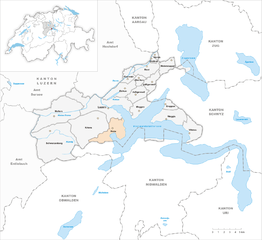
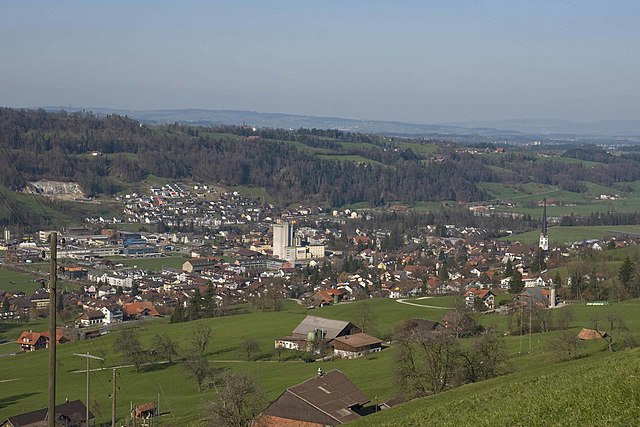
Кринс (Kriens, Kriens)

 Hiking in Кринс
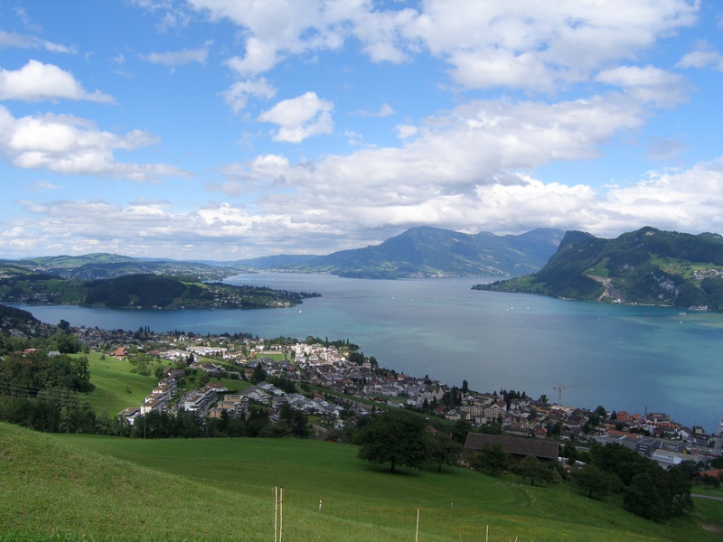
Kriens is a charming municipality located in the canton of Lucerne in Switzerland, nestled at the foot of the majestic Pilatus mountain range. It offers a variety of hiking opportunities suitable for different skill levels. Here are some highlights and recommendations for hiking in and around Kriens:
Scenic Trails
-
Pilatus Trails: The area around Mount Pilatus features numerous marked hiking trails. The most popular routes include the trail from Kriens to the summit of Pilatus, which provides stunning views of Lake Lucerne and the surrounding Alps.
-
Krienseregg: This is a popular hiking destination easily accessible from Kriens. The hike from Kriens to Krienseregg is relatively short but offers breathtaking views and a nice mix of forest and open fields.
-
Ibergeregg to Mägisalp: This hike offers beautiful landscapes and is also known for its panoramic views. It may take you several hours and is a great choice for more experienced hikers looking for a full day’s trek.
Accessibility
Kriens is well-connected by public transport, including a funicular railway that takes you up to the top of Mount Pilatus. This means you can easily access higher trails without needing to start from a lower elevation.
Tips for Hiking in Kriens
- Weather Preparedness: Mountain weather can change rapidly, so make sure to check the forecast and dress in layers.
- Trail Maps: Always carry a detailed map of the trails. Most trails are well-marked, but it’s best to have a guideline.
- Pack Essentials: Bring enough water, snacks, and a first aid kit. Always let someone know your planned route and expected return time.
- Respect Nature: Stick to marked trails and follow local guidelines to preserve the beautiful environment.
Nearby Attractions
Kriens is also close to other fantastic hiking areas, such as:
- Lake Lucerne: Offers various walking paths along the waterfront.
- Mount Rigi: Another iconic mountain with multiple hiking routes.
Overall, Kriens is a beautiful starting point for hiking adventures in the Swiss Alps, allowing hikers to experience exquisite views and diverse nature. Whether you’re a beginner or an experienced hiker, there are plenty of options to explore!
- Страна:

- Почтовый код: 6010
- Телефонный код: 041
- Код автомобильного номера: LU
- Координаты: 47° 1' 15" N, 8° 15' 32" E


- GPS треки (wikiloc): [Ссылка]
- Высота над уровнем моря: 843 м m
- Площадь: 27.31 кв.км
- Население: 26997
- Веб сайт: http://www.kriens.ch
- Википедия русская: wiki(ru)
- Википедия английская: wiki(en)
- Википедия национальная: wiki(de)
- Хранилище Wikidata: Wikidata: Q14571
- Катеория в википедии: [Ссылка]
- код Freebase: [/m/0dx638]
- код GeoNames: Альт: [7286225]
- код VIAF: Альт: [128334519]
- ID отношения в OpenStreetMap: [1682888]
- код GND: Альт: [4193261-4]
- идентификатор местоположения ArchINFORM: [1552]
- код LCNAF: Альт: [n00085876]
- место в MusicBrainz: [b0f62593-4d7f-4057-9524-316759529997]
- код TGN: [1064150]
- идентификатор HDS: [622]
- код швейцарского муниципалитета: [1059]
Граничит с регионами:

Хорв
Hiking in Хорв
Horw is a picturesque municipality located in the canton of Lucerne, Switzerland, known for its stunning natural landscapes and proximity to the Swiss Alps. Hiking in and around Horw offers a variety of trails suited for different skill levels, making it an excellent destination for both novice and experienced hikers....
- Страна:
- Почтовый код: 6048
- Телефонный код: 041
- Код автомобильного номера: LU
- Координаты: 47° 0' 48" N, 8° 18' 39" E
- GPS треки (wikiloc): [Ссылка]
- Высота над уровнем моря: 438 м m
- Площадь: 20.43 кв.км
- Население: 13915
- Веб сайт: [Ссылка]

Мальтерс
Hiking in Мальтерс
Malters is a charming municipality located in the canton of Lucerne, Switzerland. It’s nestled in the foothills of the Swiss Alps and offers a variety of hiking opportunities that cater to different skill levels....
- Страна:
- Почтовый код: 6102
- Телефонный код: 041
- Код автомобильного номера: LU
- Координаты: 47° 2' 34" N, 8° 11' 24" E
- GPS треки (wikiloc): [Ссылка]
- Высота над уровнем моря: 490 м m
- Площадь: 28.57 кв.км
- Население: 7231
- Веб сайт: [Ссылка]
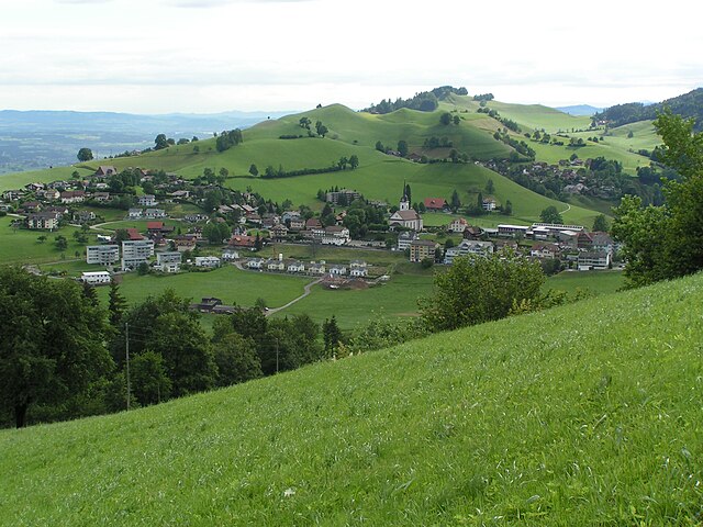

Шварценберг
Hiking in Шварценберг
Schwarzenberg, nestled in the beautiful Lucerne region of Switzerland, offers a variety of hiking opportunities that cater to different skill levels and preferences. The area is known for its stunning landscapes, characterized by rolling hills, lush forests, and picturesque views of the surrounding mountains....
- Страна:
- Почтовый код: 6103
- Телефонный код: 041
- Код автомобильного номера: LU
- Координаты: 47° 0' 51" N, 8° 10' 24" E
- GPS треки (wikiloc): [Ссылка]
- Высота над уровнем моря: 838 м m
- Площадь: 39.31 кв.км
- Население: 1690
- Веб сайт: [Ссылка]
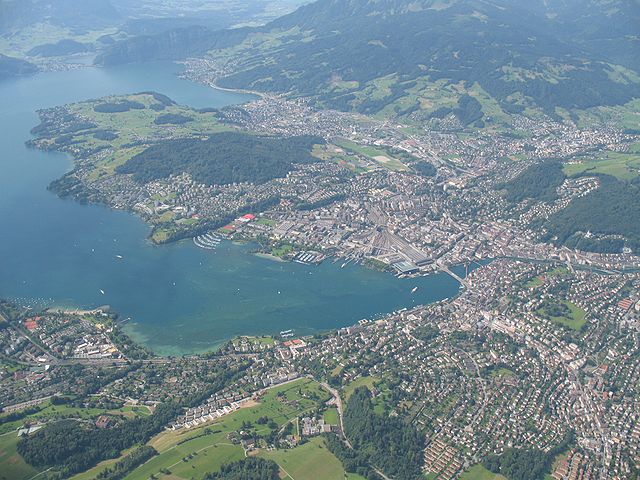

Люцерн
- город в Швейцарии, столица кантона Люцерн и административного района Люцерн
Hiking in Люцерн
Hiking in Lucerne, Switzerland, offers breathtaking views and a variety of trails that cater to different skill levels. Situated by Lake Lucerne and surrounded by majestic mountains, this region is a paradise for outdoor enthusiasts. Here are some popular hiking areas and trails you might consider:...
- Страна:
- Почтовый код: 6014; 6000
- Телефонный код: 041
- Код автомобильного номера: LU
- Координаты: 47° 3' 8" N, 8° 18' 21" E
- GPS треки (wikiloc): [Ссылка]
- Высота над уровнем моря: 436 м m
- Площадь: 37.4 кв.км
- Население: 81592
- Веб сайт: [Ссылка]

Хергисвиль
Hiking in Хергисвиль
Hergiswil is a charming village located on the shores of Lake Lucerne in Switzerland, surrounded by beautiful mountains and stunning landscapes, making it a great destination for hiking enthusiasts. Here are some key points to consider when hiking in Hergiswil:...
- Страна:
- Почтовый код: 6052
- Телефонный код: 041
- Код автомобильного номера: NW
- Координаты: 46° 59' 8" N, 8° 16' 21" E
- GPS треки (wikiloc): [Ссылка]
- Высота над уровнем моря: 1121 м m
- Площадь: 17.00 кв.км
- Население: 5715
- Веб сайт: [Ссылка]