La Latette (La Latette)

- коммуна во Франции
 Hiking in La Latette
La Latette, located in the Pyrenees mountains of France, offers a variety of hiking opportunities that cater to different skill levels and preferences. This region is characterized by stunning landscapes, diverse flora and fauna, and a range of trails that provide breathtaking views.
Key Highlights for Hiking in La Latette:
-
Scenic Trails: The area is known for its picturesque trails that often lead you through lush forests, alpine meadows, and rugged mountain terrain. Be prepared to encounter natural beauty along the way.
-
Trail Difficulty: There are multiple trails available, ranging from easy walks suitable for families to more challenging hikes for experienced adventurers. Make sure to choose a trail that matches your physical fitness and hiking experience.
-
Wildlife Viewing: The Pyrenees are home to a variety of wildlife, including deer, chamois, and numerous bird species. Hikers should keep an eye out for these animals, especially in the early mornings or late afternoons.
-
Cultural Sites: Some trails may lead you to historical or cultural landmarks, such as ancient ruins or traditional mountain villages, where you can learn about local history and culture.
-
Weather Considerations: The weather in the Pyrenees can change rapidly, so it’s important to check forecasts and be prepared for varying conditions, including rain or chilly temperatures, even in summer.
-
Safety Precautions: Make sure to bring plenty of water, snacks, a map or GPS, and the right gear, including sturdy hiking boots and weather-appropriate clothing. It's also wise to inform someone about your hiking plans.
-
Best Time to Hike: Late spring to early autumn is generally the best time for hiking in La Latette, when the trails are fully accessible and the weather is pleasant.
Before setting out, it’s advisable to consult local resources for detailed trail maps, current conditions, and any regulations regarding hiking in the area. Enjoy your adventure in La Latette!
- Страна:

- Почтовый код: 39250
- Координаты: 46° 45' 8" N, 6° 5' 25" E


- GPS треки (wikiloc): [Ссылка]
- Площадь: 5.89 кв.км
- Население: 68
- Википедия английская: wiki(en)
- Википедия национальная: wiki(fr)
- Хранилище Wikidata: Wikidata: Q670520
- Катеория в википедии: [Ссылка]
- код Freebase: [/m/03npvrs]
- код GeoNames: Альт: [6455979]
- номер SIREN: [213902828]
- код BNF: [15258645s]
- код муниципалитета INSEE: 39282
Граничит с регионами:

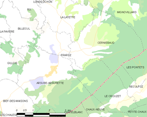
Fraroz
- коммуна во Франции
Hiking in Fraroz
Fraroz appears to be a lesser-known destination, and information on hiking specifically in that area may not be widely available. However, if you're looking for hiking guidance or recommendations for a specific region, here’s a general approach you can take:...
- Страна:
- Почтовый код: 39250
- Координаты: 46° 44' 2" N, 6° 5' 29" E
- GPS треки (wikiloc): [Ссылка]
- Площадь: 6.22 кв.км
- Население: 48


Longcochon
- коммуна во Франции
Hiking in Longcochon
Longcochon, situated in the Jura Mountains of France, is a wonderful destination for hiking enthusiasts. It offers stunning natural landscapes, lush forests, and a variety of trails that cater to different skill levels. Here are some key points to consider when hiking in Longcochon:...
- Страна:
- Почтовый код: 39250
- Координаты: 46° 46' 27" N, 6° 4' 12" E
- GPS треки (wikiloc): [Ссылка]
- Площадь: 3.64 кв.км
- Население: 58


Mignovillard
- коммуна во Франции
Hiking in Mignovillard
Mignovillard, located in the Jura department of France, is a charming destination for hiking enthusiasts. Nestled in the foothills of the Jura Mountains, it offers a variety of trails that cater to different skill levels, from leisurely walks to more challenging hikes....
- Страна:
- Почтовый код: 39250
- Координаты: 46° 47' 29" N, 6° 7' 33" E
- GPS треки (wikiloc): [Ссылка]
- Площадь: 49.81 кв.км
- Население: 743
- Веб сайт: [Ссылка]
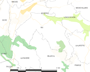
Rix
- коммуна во Франции
Hiking in Rix
Hiking in Rix, located in the Jura region of Switzerland, offers a wonderful blend of breathtaking landscapes, diverse trails, and rich natural beauty. The Jura mountains are known for their rolling hills, deep forests, and panoramic viewpoints, making them ideal for outdoor enthusiasts....
- Страна:
- Почтовый код: 39250
- Координаты: 46° 46' 9" N, 6° 2' 51" E
- GPS треки (wikiloc): [Ссылка]
- Площадь: 5.17 кв.км
- Население: 73


Cerniébaud
- коммуна во Франции
Hiking in Cerniébaud
Cerniébaud is a picturesque village located in the Jura Mountains of France, known for its stunning natural landscapes and outdoor recreational opportunities. Hiking in this area offers a wonderful mix of lush forests, rolling hills, and beautiful views of the Jura range. Here are some key points and trails to consider when hiking in Cerniébaud:...
- Страна:
- Почтовый код: 39250
- Координаты: 46° 43' 57" N, 6° 6' 14" E
- GPS треки (wikiloc): [Ссылка]
- Площадь: 10.53 кв.км
- Население: 85