Mignovillard (Mignovillard)

- коммуна во Франции
 Hiking in Mignovillard
Mignovillard, located in the Jura department of France, is a charming destination for hiking enthusiasts. Nestled in the foothills of the Jura Mountains, it offers a variety of trails that cater to different skill levels, from leisurely walks to more challenging hikes.
Key Features of Hiking in Mignovillard:
-
Scenic Natural Beauty: The area is known for its stunning landscapes, including rolling hills, lush forests, and picturesque meadows. The views of the Jura Mountains and the surrounding valleys are breathtaking, especially during sunrise and sunset.
-
Variety of Trails: There are numerous marked hiking trails that you can explore. Some popular routes include:
- Le Circuit des Vallées: A moderate trail that takes you through beautiful valleys and offers a chance to spot local wildlife.
- Sentier des Caves: A trail that leads to fascinating geological formations and caves in the area.
- La Grande Traversée du Jura: For more adventurous hikers, sections of this long-distance trail pass through Mignovillard, providing an opportunity to experience the region’s biodiversity and rugged terrain.
-
Flora and Fauna: The Jura region boasts a rich biodiversity, with many endemic plant species and diverse wildlife. Keep an eye out for various bird species and perhaps even deer or wild boar.
-
Cultural Aspects: While hiking, you may come across traditional Jura architecture and local farms, providing a glimpse into the rural life and culture of the region. Consider visiting local villages and markets for an authentic experience.
-
Seasonal Considerations: Each season offers a different hiking experience. Spring and summer are ideal for wildflower sightings, while autumn provides a stunning display of colors. Winter hiking is also popular, although proper gear is essential.
-
Local Tips:
- Always check the local weather forecast before heading out.
- Carry plenty of water and snacks, as some trails may be remote.
- Respect the natural environment and follow the principle of Leave No Trace.
-
Accommodations: Mignovillard has several lodging options, including guesthouses, campsites, and hotels, making it convenient for multi-day hiking trips.
Whether you're an experienced hiker or a beginner, Mignovillard offers a wonderful opportunity to explore the great outdoors and immerse yourself in the beauty of the Jura region.
- Страна:

- Почтовый код: 39250
- Координаты: 46° 47' 29" N, 6° 7' 33" E


- GPS треки (wikiloc): [Ссылка]
- Площадь: 49.81 кв.км
- Население: 743
- Веб сайт: http://www.mignovillard.fr
- Википедия английская: wiki(en)
- Википедия национальная: wiki(fr)
- Хранилище Wikidata: Wikidata: Q536109
- Катеория в википедии: [Ссылка]
- код Freebase: [/m/03nq839]
- код GeoNames: Альт: [2993909]
- код BNF: [152586940]
- код VIAF: Альт: [133853623]
- ID отношения в OpenStreetMap: [5811987]
- код GND: Альт: [4281508-3]
- код LCNAF: Альт: [n95058676]
- WOEID: [611499]
- код муниципалитета INSEE: 39331
Граничит с регионами:


Longcochon
- коммуна во Франции
Hiking in Longcochon
Longcochon, situated in the Jura Mountains of France, is a wonderful destination for hiking enthusiasts. It offers stunning natural landscapes, lush forests, and a variety of trails that cater to different skill levels. Here are some key points to consider when hiking in Longcochon:...
- Страна:
- Почтовый код: 39250
- Координаты: 46° 46' 27" N, 6° 4' 12" E
- GPS треки (wikiloc): [Ссылка]
- Площадь: 3.64 кв.км
- Население: 58


Molpré
- коммуна во Франции
Hiking in Molpré
Molpré is a small village located in the Jura mountains of France, known for its picturesque landscapes, lush forests, and tranquil hiking trails. While specific information about trails and conditions in Molpré might not be well-documented, the surrounding Jura region offers a wealth of opportunities for hikers of all skill levels....
- Страна:
- Почтовый код: 39250
- Координаты: 46° 47' 15" N, 6° 4' 3" E
- GPS треки (wikiloc): [Ссылка]
- Высота над уровнем моря: 787 м m
- Площадь: 2.73 кв.км
- Население: 24


Rondefontaine
- коммуна во Франции
Hiking in Rondefontaine
Rondefontaine, located in the French region of Auvergne-Rhône-Alpes, offers a beautiful setting for hiking enthusiasts. This area is known for its stunning landscapes, diverse flora and fauna, and numerous trails that cater to different skill levels. Here are some key points to consider when hiking in Rondefontaine:...
- Страна:
- Почтовый код: 25240
- Координаты: 46° 44' 0" N, 6° 10' 57" E
- GPS треки (wikiloc): [Ссылка]
- Площадь: 2.72 кв.км
- Население: 30


Bief-du-Fourg
- коммуна во Франции
Hiking in Bief-du-Fourg
Bief-du-Fourg is a picturesque area located in the Doubs region of France, known for its stunning natural landscapes and outdoor recreational opportunities, including hiking. Here are some insights and tips for hiking in Bief-du-Fourg:...
- Страна:
- Почтовый код: 39250
- Координаты: 46° 48' 34" N, 6° 6' 34" E
- GPS треки (wikiloc): [Ссылка]
- Площадь: 10.2 кв.км
- Население: 189


Bonnevaux
Hiking in Bonnevaux
Bonnevaux is a beautiful area located in the Doubs department of the Bourgogne-Franche-Comté region in eastern France. It's known for its stunning natural landscapes, lush forests, and serene environment, making it a great destination for hiking enthusiasts....
- Страна:
- Почтовый код: 25560
- Координаты: 46° 48' 30" N, 6° 11' 7" E
- GPS треки (wikiloc): [Ссылка]
- Площадь: 16.53 кв.км
- Население: 375
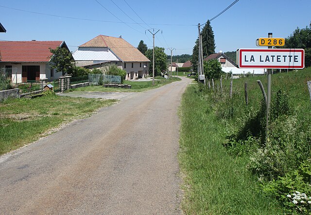

La Latette
- коммуна во Франции
Hiking in La Latette
La Latette, located in the Pyrenees mountains of France, offers a variety of hiking opportunities that cater to different skill levels and preferences. This region is characterized by stunning landscapes, diverse flora and fauna, and a range of trails that provide breathtaking views....
- Страна:
- Почтовый код: 39250
- Координаты: 46° 45' 8" N, 6° 5' 25" E
- GPS треки (wikiloc): [Ссылка]
- Площадь: 5.89 кв.км
- Население: 68


Communailles-en-Montagne
- коммуна во Франции
Hiking in Communailles-en-Montagne
Communailles-en-Montagne, located in the picturesque Jura region of eastern France, offers a range of hiking opportunities for outdoor enthusiasts. The area is characterized by its stunning landscapes, dense forests, rolling hills, and scenic viewpoints, making it an excellent destination for hikers of all skill levels....
- Страна:
- Почтовый код: 39250
- Координаты: 46° 47' 57" N, 6° 5' 53" E
- GPS треки (wikiloc): [Ссылка]
- Площадь: 4.01 кв.км
- Население: 51

Vaux-et-Chantegrue
- коммуна во Франции
Hiking in Vaux-et-Chantegrue
Vaux-et-Chantegrue is a charming village in the Jura region of France, known for its picturesque landscapes, rolling hills, and tranquil natural surroundings. The area offers several hiking opportunities that allow you to explore its beauty....
- Страна:
- Почтовый код: 25160
- Координаты: 46° 48' 39" N, 6° 14' 59" E
- GPS треки (wikiloc): [Ссылка]
- Площадь: 13.98 кв.км
- Население: 544


Censeau
- коммуна во Франции
Hiking in Censeau
Censeau is a lesser-known area in France that may not be widely recognized in hiking circles, but it likely offers beautiful landscapes and trails typical of the surrounding regions. Since specific information about Censeau may vary, here's some general advice and things to consider if you're planning a hiking trip there:...
- Страна:
- Почтовый код: 39250
- Координаты: 46° 48' 49" N, 6° 4' 5" E
- GPS треки (wikiloc): [Ссылка]
- Площадь: 9.86 кв.км
- Население: 299


Cerniébaud
- коммуна во Франции
Hiking in Cerniébaud
Cerniébaud is a picturesque village located in the Jura Mountains of France, known for its stunning natural landscapes and outdoor recreational opportunities. Hiking in this area offers a wonderful mix of lush forests, rolling hills, and beautiful views of the Jura range. Here are some key points and trails to consider when hiking in Cerniébaud:...
- Страна:
- Почтовый код: 39250
- Координаты: 46° 43' 57" N, 6° 6' 14" E
- GPS треки (wikiloc): [Ссылка]
- Площадь: 10.53 кв.км
- Население: 85


Mièges
- коммуна во Франции
Hiking in Mièges
Mièges is a charming village located in the Jura department of France, surrounded by beautiful natural landscapes that are perfect for hiking enthusiasts. The area features rolling hills, dense forests, and panoramic views, making it a great destination for outdoor activities....
- Страна:
- Почтовый код: 39250
- Координаты: 46° 46' 57" N, 6° 2' 13" E
- GPS треки (wikiloc): [Ссылка]
- Площадь: 3.19 кв.км
- Население: 99


Ле-Понтет
- коммуна во Франции
Hiking in Ле-Понтет
Les Pontets is a fantastic area for hiking, located in the picturesque surroundings of the French Alps, near the border of Switzerland. This region is known for its stunning landscapes, including lush valleys, majestic mountain peaks, and picturesque lakes. Here are some highlights about hiking in and around Les Pontets:...
- Страна:
- Почтовый код: 25240
- Координаты: 46° 43' 9" N, 6° 10' 18" E
- GPS треки (wikiloc): [Ссылка]
- Площадь: 6.36 кв.км
- Население: 142

Remoray-Boujeons
- коммуна во Франции
Hiking in Remoray-Boujeons
Remoray-Boujeons, located in the Jura Mountains of France, offers a variety of hiking opportunities that are perfect for outdoor enthusiasts of all levels. This region is known for its beautiful landscapes, rich biodiversity, and serene lakes. Here are some key points to consider when planning a hike in the area:...
- Страна:
- Почтовый код: 25160
- Координаты: 46° 46' 3" N, 6° 14' 20" E
- GPS треки (wikiloc): [Ссылка]
- Площадь: 15.15 кв.км
- Население: 412