
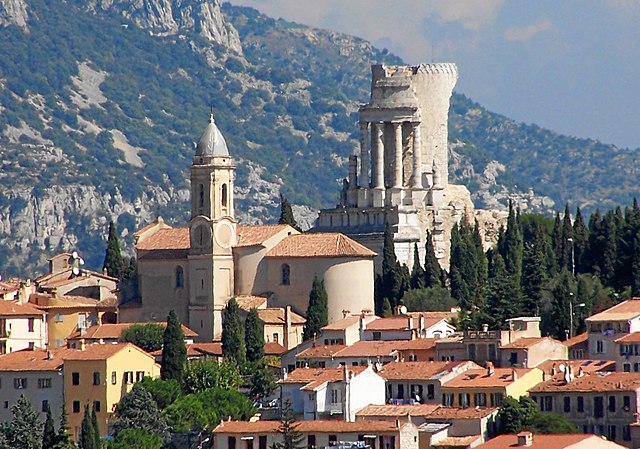
Ла-Трините (La Trinité, La Trinité)

- коммуна в департаменте Приморские Альпы, регион Прованс — Альпы — Лазурный Берег, Франция
 Hiking in Ла-Трините
La Trinité, located in the Alpes-Maritimes department of France, offers several beautiful hiking opportunities for outdoor enthusiasts. Nestled near Nice and the Mediterranean coast, it provides a mix of coastal views, lush greenery, and panoramic mountain scenery. Here are some highlights and considerations for hiking in this area:
Hiking Trails
-
Chemin de Saint-Bernard: This trail offers stunning views of the surrounding hills and valleys. It’s an excellent option for both beginner and experienced hikers.
-
Mont Agel: A popular hike that leads to the summit of Mont Agel, giving hikers panoramic views of the French Riviera. The trail is moderately challenging but rewarding.
-
Les hauteurs de La Trinité: Trails that provide various loops and distances, bringing you through forests and offering breathtaking views. You might encounter local wildlife and diverse flora.
-
Col de la Madone: A well-known area among cyclists, it also offers hiking routes. The ascent to the col is steep but brings spectacular views of the surrounding landscape.
Tips for Hiking in La Trinité
- Weather: Check the weather conditions before heading out, especially during warmer months when temperatures can rise quickly.
- Gear: Wear appropriate hiking shoes and bring enough water and snacks, as some trails can be longer than anticipated.
- Trail Markings: Trails are generally well-marked; however, having a map or a GPS device can be useful for navigation.
- Local Regulations: Adhere to local regulations regarding trail use and wildlife protection.
- Wildlife: Be cautious and respectful of local wildlife. Keep a safe distance and avoid feeding animals.
Accessibility
La Trinité is easily accessible from Nice and other nearby towns, making it a convenient option for day hikes. Public transportation options, such as buses, can take you close to various trailheads.
Conclusion
Hiking in La Trinité offers a blend of natural beauty, moderate to challenging trails, and convenient access. Whether you're looking for a peaceful walk or a strenuous hike, this area provides excellent options for all levels of hikers. Always remember to leave no trace and respect the environment while enjoying the outdoors.
- Страна:

- Почтовый код: 06340
- Координаты: 43° 44' 27" N, 7° 18' 51" E


- GPS треки (wikiloc): [Ссылка]
- Площадь: 14.9 кв.км
- Население: 10222
- Веб сайт: http://www.ville-de-la-trinité.fr
- Википедия русская: wiki(ru)
- Википедия английская: wiki(en)
- Википедия национальная: wiki(fr)
- Хранилище Wikidata: Wikidata: Q383475
- Катеория в википедии: [Ссылка]
- код Freebase: [/m/02r1wcc]
- код Freebase: [/m/02r1wcc]
- код GeoNames: Альт: [6455475]
- код GeoNames: Альт: [6455475]
- номер SIREN: [210601498]
- номер SIREN: [210601498]
- код BNF: [131274108]
- код BNF: [131274108]
- код VIAF: Альт: [149055565]
- код VIAF: Альт: [149055565]
- код LCNAF: Альт: [n90683473]
- код LCNAF: Альт: [n90683473]
- код SUDOC: [055392032]
- код SUDOC: [055392032]
- код муниципалитета INSEE: 06149
- код муниципалитета INSEE: 06149
Граничит с регионами:


Драп
- коммуна в департаменте Приморские Альпы, регион Прованс — Альпы — Лазурный Берег, Франция
Hiking in Драп
Hiking in Drap, Utah, offers a variety of beautiful trails and stunning scenery, suited for all levels of experience. Drap is located at the foot of the Wasatch Range, giving hikers access to diverse landscapes, from the foothills to rugged mountain trails....
- Страна:
- Почтовый код: 06340
- Координаты: 43° 45' 18" N, 7° 19' 17" E
- GPS треки (wikiloc): [Ссылка]
- Площадь: 5.54 кв.км
- Население: 4444
- Веб сайт: [Ссылка]


Эз
- коммуна в департаменте Приморские Альпы, регион Прованс — Альпы — Лазурный Берег, Франция
- Страна:
- Почтовый код: 06360
- Координаты: 43° 43' 40" N, 7° 21' 40" E
- GPS треки (wikiloc): [Ссылка]
- Высота над уровнем моря: 424 м m
- Площадь: 9.47 кв.км
- Население: 2343
- Веб сайт: [Ссылка]
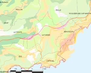
Ла-Тюрби
- коммуна в департаменте Приморские Альпы, регион Прованс — Альпы — Лазурный Берег, Франция
- Страна:
- Почтовый код: 06320
- Координаты: 43° 44' 44" N, 7° 24' 3" E
- GPS треки (wikiloc): [Ссылка]
- Площадь: 7.42 кв.км
- Население: 3119
- Веб сайт: [Ссылка]

Пейон
- коммуна в департаменте Приморские Альпы, регион Прованс — Альпы — Лазурный Берег, Франция
Hiking in Пейон
Peillon is a charming medieval village located in the French Riviera, not far from Nice. Nestled in the hills, it offers stunning views of the surrounding landscape, making it a wonderful destination for hiking enthusiasts....
- Страна:
- Почтовый код: 06440
- Координаты: 43° 46' 7" N, 7° 22' 2" E
- GPS треки (wikiloc): [Ссылка]
- Площадь: 8.7 кв.км
- Население: 1483


Ницца
- коммуна в департаменте Приморские Альпы, регион Прованс — Альпы — Лазурный Берег, Франция
- Страна:
- Почтовый код: 06000
- Телефонный код: 493
- Координаты: 43° 42' 7" N, 7° 16' 6" E
- GPS треки (wikiloc): [Ссылка]
- Высота над уровнем моря: 10 м m
- Площадь: 71.92 кв.км
- Население: 342522
- Веб сайт: [Ссылка]

Кантарон
- коммуна в департаменте Приморские Альпы, регион Прованс — Альпы — Лазурный Берег, Франция
Hiking in Кантарон
Cantaron is a charming village located in the Alpes-Maritimes department of southeastern France, near Nice. It's a fantastic destination for hiking enthusiasts, offering a mix of scenic trails, beautiful landscapes, and a rich cultural experience. Here are some highlights regarding hiking in and around Cantaron:...
- Страна:
- Почтовый код: 06340
- Координаты: 43° 45' 42" N, 7° 19' 7" E
- GPS треки (wikiloc): [Ссылка]
- Площадь: 7.38 кв.км
- Население: 1337
- Веб сайт: [Ссылка]

Пей
- коммуна в департаменте Приморские Альпы, регион Прованс — Альпы — Лазурный Берег, Франция
Hiking in Пей
Peille is a charming village located in the Alpes-Maritimes department in the Provence-Alpes-Côte d'Azur region of France. Nestled in the hills above the Mediterranean, it offers a variety of hiking opportunities with stunning views, lush vegetation, and a rich history....
- Страна:
- Почтовый код: 06440
- Координаты: 43° 48' 9" N, 7° 24' 6" E
- GPS треки (wikiloc): [Ссылка]
- Площадь: 43.16 кв.км
- Население: 2353
- Веб сайт: [Ссылка]