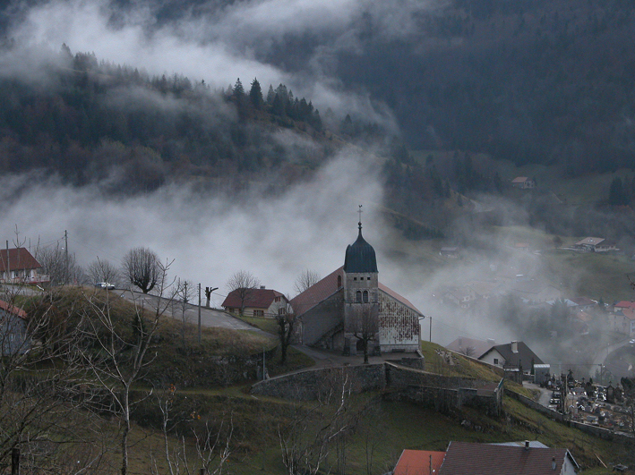
Лажу (Lajoux, Lajoux)

- коммуна во Франции
 Hiking in Лажу
Lajoux, a charming village located in the Jura region of France, offers a picturesque setting for hiking enthusiasts. Nestled in a stunning landscape characterized by rolling hills, dense forests, and beautiful meadows, it serves as an excellent base for exploring the surrounding natural beauty.
Hiking Trails:
-
Circuit du Grand Crêt: This trail offers a moderate hike with stunning panoramic views of the Jura mountains. It's approximately 10 kilometers long and takes you through diverse terrains featuring lush forests and open pastures.
-
Sentier des Vaches: A shorter trail ideal for families, this path leads you through scenic countryside and offers opportunities to spot local wildlife and farm animals. It's about 4 kilometers long and suitable for all skill levels.
-
Col de la Faucille: A bit further from Lajoux, this area is known for more challenging hikes with breathtaking viewpoints. Trails here can connect you with routes leading to peaks such as Mont Rond.
Best Time to Hike:
Late spring through early fall (May to September) is typically the best time for hiking in Lajoux. The weather is usually mild, and you’ll experience vibrant flowers in bloom and clear visibility for stunning mountain views.
Preparation:
- Gear: Ensure you have sturdy hiking boots, appropriate clothing layers, a hat for sun protection, and plenty of water.
- Maps and Guides: Utilize local maps or GPS devices to navigate the trails as some paths may not be clearly marked. There are also local guide services available for those looking for a guided experience.
- Wildlife: Be mindful of local wildlife, including deer and various bird species, and be respectful of their habitats.
Other Activities:
Apart from hiking, Lajoux also offers opportunities for mountain biking, skiing in winter, and exploring the rich local culture. Don’t miss the opportunity to visit local farms and try regional cheeses, especially the Comté.
Overall, hiking in Lajoux and the surrounding Jura region is a chance to immerse yourself in nature, enjoy stunning landscapes, and experience the tranquility of rural France. Always check local trail conditions and any regulations before setting out. Happy hiking!
- Страна:

- Почтовый код: 01410
- Координаты: 46° 22' 30" N, 5° 58' 18" E


- GPS треки (wikiloc): [Ссылка]
- Площадь: 23.65 кв.км
- Население: 248
- Википедия русская: wiki(ru)
- Википедия английская: wiki(en)
- Википедия национальная: wiki(fr)
- Хранилище Wikidata: Wikidata: Q684064
- Катеория в википедии: [Ссылка]
- код Freebase: [/m/03npvr2]
- код GeoNames: Альт: [6433589]
- номер SIREN: [213902745]
- код BNF: [152586375]
- код муниципалитета INSEE: 39274
Граничит с регионами:

Мижу
- коммуна на востоке Франции, префектура департамента Эн.
Hiking in Мижу
Mijoux is a charming commune located in the Jura region of France, known for its beautiful landscapes and outdoor activities, particularly hiking. Nestled near the Swiss border and surrounded by rolling hills, forests, and scenic views, Mijoux offers a great starting point for various hiking trails suitable for different skill levels. Here are some key points to consider when hiking in Mijoux:...
- Страна:
- Почтовый код: 01170
- Координаты: 46° 21' 58" N, 5° 59' 43" E
- GPS треки (wikiloc): [Ссылка]
- Площадь: 22 кв.км
- Население: 336
- Веб сайт: [Ссылка]

Дивон-ле-Бен
- коммуна во Франции
Hiking in Дивон-ле-Бен
Divonne-les-Bains, located in the Auvergne-Rhône-Alpes region of France near the Swiss border, is a beautiful spot for hiking enthusiasts. The area is known for its stunning natural landscapes, including the Jura Mountains, which provide a wide range of trails catering to different skill levels....
- Страна:
- Почтовый код: 01220
- Координаты: 46° 21' 24" N, 6° 8' 34" E
- GPS треки (wikiloc): [Ссылка]
- Площадь: 33.88 кв.км
- Население: 9286
- Веб сайт: [Ссылка]

Septmoncel
- коммуна во Франции
Hiking in Septmoncel
Septmoncel is a picturesque village located in the Jura Mountains of France, known for its beautiful natural landscapes and various outdoor activities, including hiking. Here are some key points to consider if you're planning a hiking trip in Septmoncel:...
- Страна:
- Почтовый код: 39310
- Координаты: 46° 22' 14" N, 5° 54' 47" E
- GPS треки (wikiloc): [Ссылка]
- Площадь: 19.4 кв.км
- Население: 683


Lamoura
- коммуна во Франции
Hiking in Lamoura
Lamoura is a picturesque village located in the Jura Mountains of France, known for its stunning natural surroundings and excellent hiking opportunities. Here are some key points to consider when hiking in Lamoura:...
- Страна:
- Почтовый код: 39310
- Координаты: 46° 23' 43" N, 5° 58' 0" E
- GPS треки (wikiloc): [Ссылка]
- Площадь: 22.28 кв.км
- Население: 617


Prémanon
- коммуна во Франции
Hiking in Prémanon
Prémanon is a picturesque village situated in the Jura Mountains in eastern France, known for its stunning natural landscapes and outdoor recreational opportunities, including hiking. Here are some key features and details about hiking in Prémanon:...
- Страна:
- Почтовый код: 39220
- Координаты: 46° 27' 43" N, 6° 1' 53" E
- GPS треки (wikiloc): [Ссылка]
- Площадь: 28.18 кв.км
- Население: 1177
- Веб сайт: [Ссылка]


Les Molunes
- коммуна во Франции
Hiking in Les Molunes
Les Molunes is a picturesque area that offers a range of hiking opportunities, typically situated within the Jura mountain range in France. The region is known for its scenic landscapes, diverse ecosystems, and rich flora and fauna, making it a favored destination for outdoor enthusiasts....
- Страна:
- Почтовый код: 39310
- Координаты: 46° 20' 42" N, 5° 55' 25" E
- GPS треки (wikiloc): [Ссылка]
- Высота над уровнем моря: 1274 м m
- Площадь: 20.51 кв.км
- Население: 156