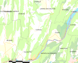
Lavans-sur-Valouse (Lavans-sur-Valouse)

- коммуна во Франции
 Hiking in Lavans-sur-Valouse
Lavans-sur-Valouse is a charming commune located in the Jura department of France. Nestled in the picturesque landscapes of the Jura Mountains, it offers a variety of hiking options that cater to different skill levels. Here's what you can expect when hiking in and around Lavans-sur-Valouse:
Hiking Trails
-
Local Trails: The area features several marked trails ranging from easy to moderate difficulty. These paths wind through lush forests, rolling hills, and scenic views of the Valouse River.
-
Nature Reserves: Nearby, you can explore protected areas that provide a glimpse into the region's diverse flora and fauna. Look for information boards that often detail local wildlife and plant species.
-
Panoramic Views: Many trails offer stunning vistas of the surrounding Jura landscapes, with opportunities to spot charming villages and the distant Alps on clear days.
Things to Consider
- Weather: The weather can change rapidly in this region, so it's essential to dress in layers, bring waterproof gear, and check forecasts before heading out.
- Trail Conditions: Some trails may be rugged or poorly maintained, especially after heavy rains. Be sure to choose trails that match your skill level and consult local sources for up-to-date trail conditions.
- Equipment: Good hiking boots are essential, and trekking poles can be beneficial on steep or uneven terrain.
Local Attractions
- Cultural Sites: Besides hiking, Lavans-sur-Valouse has a few historical sites and local attractions that reflect the regional heritage. Consider taking breaks to explore these sites during your hikes.
- Picnic Areas: Many trails may have designated picnic spots where you can relax and enjoy a meal surrounded by nature.
Overall, hiking in Lavans-sur-Valouse offers a delightful opportunity to experience the natural beauty of the Jura region while enjoying a peaceful outdoor environment. Whether you're planning a short stroll or a more challenging hike, you'll find plenty to explore. Just remember to follow Leave No Trace principles to preserve the beauty of the area for future hikers!
- Страна:

- Почтовый код: 39240
- Координаты: 46° 20' 30" N, 5° 33' 53" E


- GPS треки (wikiloc): [Ссылка]
- Площадь: 9.51 кв.км
- Население: 146
- Википедия английская: wiki(en)
- Википедия национальная: wiki(fr)
- Хранилище Wikidata: Wikidata: Q392219
- Катеория в википедии: [Ссылка]
- код Freebase: [/m/0cbgn5]
- код GeoNames: Альт: [6433597]
- номер SIREN: [213902877]
- код BNF: [15258650c]
- код муниципалитета INSEE: 39287
Граничит с регионами:


Cézia
- коммуна во Франции
Hiking in Cézia
As of my last update, there's no widely recognized location known as "Cézia" in hiking literature or guides. It’s possible that it could refer to a lesser-known area, a local nickname, or perhaps a typographical error. If you meant a specific region or park and can clarify or provide additional context, I would be more than happy to help!...
- Страна:
- Почтовый код: 39240
- Координаты: 46° 21' 37" N, 5° 34' 29" E
- GPS треки (wikiloc): [Ссылка]
- Площадь: 3.6 кв.км
- Население: 69


Vescles
- коммуна во Франции
Hiking in Vescles
It seems there might be a minor confusion regarding the location you're referring to as "Vescles." There isn't a well-known hiking area by that name. However, if you meant "Vesicles" or another location that sounds similar, please provide more context or check the spelling....
- Страна:
- Почтовый код: 39240
- Координаты: 46° 21' 37" N, 5° 36' 48" E
- GPS треки (wikiloc): [Ссылка]
- Площадь: 20.27 кв.км
- Население: 197


Vosbles
- коммуна во Франции
Hiking in Vosbles
It seems there might be a typo in your query, as "Vosbles" doesn't relate to a known hiking destination. If you meant "Vosges," which is a mountain range in northeastern France, I can certainly provide information on that!...
- Страна:
- Почтовый код: 39240
- Координаты: 46° 20' 25" N, 5° 31' 28" E
- GPS треки (wikiloc): [Ссылка]
- Площадь: 12.67 кв.км
- Население: 110

Cornod
- коммуна во Франции
Hiking in Cornod
It seems there might be a confusion regarding "Cornod." If you meant "Croatia," "Cordillera," or another specific place, please clarify, and I'd be happy to provide information about hiking in that area....
- Страна:
- Почтовый код: 39240
- Координаты: 46° 18' 48" N, 5° 32' 56" E
- GPS треки (wikiloc): [Ссылка]
- Площадь: 13.99 кв.км
- Население: 222


Coisia
- коммуна во Франции
Hiking in Coisia
It seems there might be a typo in your request, as "Coisia" is not a recognized hiking destination. If you meant "Corsica," which is a beautiful island in the Mediterranean Sea, I can provide some information on hiking there....
- Страна:
- Почтовый код: 39240
- Координаты: 46° 18' 20" N, 5° 34' 51" E
- GPS треки (wikiloc): [Ссылка]
- Площадь: 6.73 кв.км
- Население: 193


Chemilla
- коммуна во Франции
Hiking in Chemilla
Chemilla, located in the region of the Basque Country in Spain, offers beautiful landscapes and diverse hiking opportunities. Here are some key points to consider for hiking in Chemilla:...
- Страна:
- Почтовый код: 39240
- Координаты: 46° 21' 26" N, 5° 33' 36" E
- GPS треки (wikiloc): [Ссылка]
- Площадь: 1.87 кв.км
- Население: 111


Chisséria
- коммуна во Франции
Hiking in Chisséria
Chisséria, often referred to as a hidden gem for outdoor enthusiasts, offers a variety of hiking trails that cater to different skill levels and provide stunning landscapes. While specific trail names and detailed mapping can vary, here are some general highlights and tips for hiking in the Chisséria region:...
- Страна:
- Почтовый код: 39240
- Координаты: 46° 22' 46" N, 5° 33' 47" E
- GPS треки (wikiloc): [Ссылка]
- Площадь: 7.25 кв.км
- Население: 72