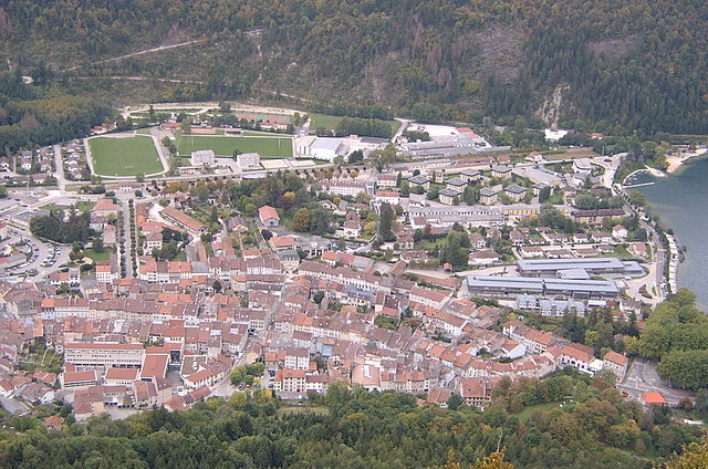
Ле-Нероль (Les Neyrolles, Les Neyrolles)
- коммуна во Франции
 Hiking in Ле-Нероль
Les Neyrolles, located in the Jura Mountains of France, offers a fantastic setting for hiking enthusiasts. This region is known for its lush greenery, rolling hills, and panoramic views. Here are some highlights and tips for hiking in Les Neyrolles:
Hiking Trails:
- Varied Terrain: The area features a network of trails that cater to all levels of hikers, from easy walks to more challenging hikes.
- Scenic Views: Many trails offer spectacular views of the surrounding Jura landscape, including valleys, forests, and, on clear days, the Alps in the distance.
- Nature Reserves: The area is home to diverse flora and fauna, making it great for nature observation. Look for informational signs along the trails that explain the local ecology.
Recommended Hikes:
- Col de la Faucille: This area offers a range of trails, including routes that lead to lookout points with breathtaking views of the surrounding mountains.
- Lac de Lamoura: A picturesque lake where you can enjoy a leisurely hike around it or take a more challenging route that leads into the surrounding woodlands.
Tips for Hiking in Les Neyrolles:
- Check Trail Conditions: Before heading out, check the local trail conditions, as weather can change quickly in mountainous areas.
- Dress Appropriately: Wear layers to adjust to temperature fluctuations, and sturdy hiking boots are a must for uneven terrain.
- Stay Hydrated: Bring plenty of water and snacks, especially for longer hikes.
- Wildlife Awareness: Keep an eye out for local wildlife, and respect their habitats by staying on designated trails.
- Navigation Tools: While many trails are well-marked, having a map or a GPS device can be helpful, especially on less-traveled paths.
Local Culture:
Explore the nearby villages to experience the local culture, including traditional Jura cuisine. Don’t miss out on sampling some local cheeses!
Whether you're looking for a peaceful day out in nature or a more strenuous adventure, Les Neyrolles provides a beautiful and rewarding hiking experience. Be sure to enjoy the serenity of the landscape and the fresh mountain air!
- Страна:

- Почтовый код: 01130
- Координаты: 46° 8' 30" N, 5° 38' 1" E


- GPS треки (wikiloc): [Ссылка]
- Площадь: 9.5 кв.км
- Население: 635
- Википедия русская: wiki(ru)
- Википедия английская: wiki(en)
- Википедия национальная: wiki(fr)
- Хранилище Wikidata: Wikidata: Q275230
- Катеория в википедии: [Ссылка]
- Карты в википедии: [Ссылка]
- код Freebase: [/m/03czg3v]
- код Freebase: [/m/03czg3v]
- код GeoNames: Альт: [6455423]
- код GeoNames: Альт: [6455423]
- номер SIREN: [210102745]
- номер SIREN: [210102745]
- код тезауруса PACTOLS: [pcrtroZb7dUh0y]
- код тезауруса PACTOLS: [pcrtroZb7dUh0y]
- код муниципалитета INSEE: 01274
- код муниципалитета INSEE: 01274
Граничит с регионами:
Нантюа
- коммуна во Франции
Hiking in Нантюа
Nantua, located in the Ain department of the Auvergne-Rhône-Alpes region in southeastern France, is a beautiful spot for hiking enthusiasts. Nestled near the Jura Mountains and surrounding a picturesque lake, Nantua offers a variety of scenic trails with stunning views of nature, local wildlife, and breathtaking landscapes....
- Страна:
- Почтовый код: 01460
- Координаты: 46° 9' 12" N, 5° 36' 22" E
- GPS треки (wikiloc): [Ссылка]
- Площадь: 12.79 кв.км
- Население: 3525
- Веб сайт: [Ссылка]

Брено
- коммуна во Франции
Hiking in Брено
Brénod is a charming commune located in the Ain department in the Auvergne-Rhône-Alpes region of France. It is situated at the foothills of the Jura mountains, making it a great starting point for various hiking adventures....
- Страна:
- Почтовый код: 01110
- Координаты: 46° 3' 39" N, 5° 36' 22" E
- GPS треки (wikiloc): [Ссылка]
- Площадь: 23.79 кв.км
- Население: 536
- Веб сайт: [Ссылка]

Шари (коммуна)
- коммуна во Франции
Hiking in Шари (коммуна)
Charix, a picturesque village located in the Haute-Savoie region of France, offers numerous hiking opportunities, especially for those looking to explore the stunning landscapes of the Alps. Here are some key points to consider when hiking in Charix:...
- Страна:
- Почтовый код: 01130
- Координаты: 46° 11' 0" N, 5° 41' 3" E
- GPS треки (wikiloc): [Ссылка]
- Площадь: 18.27 кв.км
- Население: 285
Haut-Valromey
Hiking in Haut-Valromey
Haut-Valromey is a beautiful region located in the French Alps, known for its stunning landscapes and outdoor activities, particularly hiking. Here are some key points to consider if you plan to hike in Haut-Valromey:...
- Страна:
- Почтовый код: 01260
- Координаты: 45° 59' 51" N, 5° 41' 42" E
- GPS треки (wikiloc): [Ссылка]
- Площадь: 107.85 кв.км
- Веб сайт: [Ссылка]

Le Poizat-Lalleyriat
Hiking in Le Poizat-Lalleyriat
Le Poizat-Lalleyriat is a picturesque village located in the Ain department of the Auvergne-Rhône-Alpes region in France. It's nestled in the Jura Mountains, making it a fantastic destination for hiking enthusiasts. Here are some highlights and tips for hiking in this area:...
- Страна:
- Почтовый код: 01130
- Координаты: 46° 8' 42" N, 5° 41' 46" E
- GPS треки (wikiloc): [Ссылка]
- Площадь: 33.15 кв.км
- Веб сайт: [Ссылка]

Ле-Гранд-Абержеман
- коммуна во Франции
Hiking in Ле-Гранд-Абержеман
Le Grand-Abergement is a picturesque commune located in the Ain department of the Auvergne-Rhône-Alpes region in France. Surrounded by lush landscapes, it offers a range of hiking opportunities that cater to different skill levels, making it an excellent destination for outdoor enthusiasts....
- Страна:
- Почтовый код: 01260
- Координаты: 46° 2' 2" N, 5° 40' 30" E
- GPS треки (wikiloc): [Ссылка]
- Площадь: 31.92 кв.км
- Население: 134

Ле-Петит-Абержман
- коммуна во Франции
Hiking in Ле-Петит-Абержман
Le Petit-Abergement is a charming village located in the Auvergne-Rhône-Alpes region of France, nestled in the stunning landscapes of the Jura Mountains. This area offers a variety of hiking opportunities for all skill levels, whether you're an experienced hiker or a beginner looking for a scenic day out....
- Страна:
- Почтовый код: 01260
- Координаты: 46° 1' 57" N, 5° 39' 49" E
- GPS треки (wikiloc): [Ссылка]
- Площадь: 26.95 кв.км
- Население: 133

Сен-Мартен-дю-Френ
- коммуна во Франции
Hiking in Сен-Мартен-дю-Френ
Saint-Martin-du-Frêne, located in the Ain department of the Auvergne-Rhône-Alpes region in France, offers a variety of beautiful hiking opportunities set against the backdrop of the stunning Jura Mountains. The area is recognized for its picturesque landscapes, lush forests, and diverse wildlife, making it an excellent destination for outdoor enthusiasts....
- Страна:
- Почтовый код: 01430
- Координаты: 46° 8' 20" N, 5° 33' 9" E
- GPS треки (wikiloc): [Ссылка]
- Площадь: 19.14 кв.км
- Население: 1076
- Веб сайт: [Ссылка]

Ле-Пуаза
- коммуна во Франции
Hiking in Ле-Пуаза
Le Poizat is a charming village located in the Ain department of the Auvergne-Rhône-Alpes region in eastern France. It is situated at the foothills of the Jura Mountains, making it an excellent location for hiking enthusiasts....
- Страна:
- Почтовый код: 01130
- Координаты: 46° 8' 39" N, 5° 41' 44" E
- GPS треки (wikiloc): [Ссылка]
- Площадь: 17.9 кв.км
- Население: 454