Ле-Пен-Мирабо (Les Pennes-Mirabeau, Les Pennes-Mirabeau)

- коммуна на юго-востоке Франции
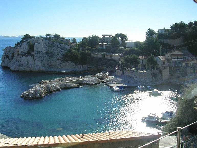
 Hiking in Ле-Пен-Мирабо
Les Pennes-Mirabeau, located in the Provence-Alpes-Côte d'Azur region in southeastern France, is a charming area that offers a variety of hiking opportunities. Nestled near Marseille, it provides a blend of picturesque landscapes, natural parks, and cultural experiences.
Hiking Trails
-
Montagne de la Louve: This is a popular hiking spot that allows you to explore the natural beauty of the region. The trails here vary in difficulty and length, making it suitable for both novice and experienced hikers. You can enjoy panoramic views of the surrounding countryside.
-
Parc Naturel Régional des Calanques: Although not directly in Les Pennes-Mirabeau, the nearby Calanques National Park is accessible and offers stunning coastal hikes. The park is famous for its rugged cliffs, clear blue waters, and diverse flora and fauna. Trails range from easy walks to challenging scrambles.
-
Les collines de Pennes-Mirabeau: The hills around Les Pennes-Mirabeau have several walking paths that take you through vineyards and olive groves. These trails are great for leisurely walks and offer a glimpse of the local agriculture and landscapes.
Preparation and Safety
- Proper Footwear: Good hiking boots are essential for the varied terrain.
- Weather Awareness: Always check the weather before heading out, as conditions can change rapidly, particularly in the warmer months.
- Water and Snacks: Carry enough water and snacks, especially if you're planning longer hikes.
- Trail Maps: Downloading maps or apps with offline capabilities can be helpful as some areas may have limited signal.
Other Activities
In addition to hiking, Les Pennes-Mirabeau offers opportunities for cycling and exploring local vineyards. You can also enjoy the region's rich culinary offerings, with many restaurants featuring Provencal cuisine.
Best Time to Hike
The best times to hike in the area are during spring (April to June) and early autumn (September to October) when the weather is generally mild and the landscapes are lush.
Exploring Les Pennes-Mirabeau on foot can provide a wonderful experience of the natural and cultural richness of Provence. Enjoy your hiking adventure!
- Страна:

- Почтовый код: 13170
- Координаты: 43° 24' 36" N, 5° 18' 34" E


- GPS треки (wikiloc): [Ссылка]
- Площадь: 33.66 кв.км
- Население: 21387
- Веб сайт: http://www.pennes-mirabeau.org
- Википедия русская: wiki(ru)
- Википедия английская: wiki(en)
- Википедия национальная: wiki(fr)
- Хранилище Wikidata: Wikidata: Q243100
- Катеория в википедии: [Ссылка]
- код Freebase: [/m/02rpcp8]
- код GeoNames: Альт: [3000047]
- номер SIREN: [211300710]
- код BNF: [152473534]
- код VIAF: Альт: [128044964]
- код GND: Альт: [4495918-7]
- код LCNAF: Альт: [n2004039789]
- код тезауруса PACTOLS: [pcrtpKxnIBehWE]
- место в MusicBrainz: [fed92c9b-6c32-4e33-8081-bf9a696628cc]
- WOEID: [607090]
- код муниципалитета INSEE: 13071
Граничит с регионами:


Бук-Бель-Эр
- коммуна во Франции
Hiking in Бук-Бель-Эр
Bouc-Bel-Air is a charming commune located in the Provence-Alpes-Côte d'Azur region of southern France, near Marseille. With its scenic landscapes and proximity to natural parks, it's a great locale for hiking enthusiasts. Here are some highlights of hiking in Bouc-Bel-Air:...
- Страна:
- Почтовый код: 13320
- Координаты: 43° 27' 16" N, 5° 24' 52" E
- GPS треки (wikiloc): [Ссылка]
- Площадь: 21.75 кв.км
- Население: 14351
- Веб сайт: [Ссылка]


Витроль
- коммуна во Франции
- Страна:
- Почтовый код: 13127
- Координаты: 43° 26' 53" N, 5° 14' 59" E
- GPS треки (wikiloc): [Ссылка]
- Площадь: 36.58 кв.км
- Население: 34089
- Веб сайт: [Ссылка]

Марсель
- коммуна во Франции
Hiking in Марсель
Hiking in Marseille offers a wonderful blend of stunning coastal views, dramatic landscapes, and rich natural biodiversity. The Calanques National Park, located just south of the city, is a highlight for hikers. Here are some key aspects to consider when hiking in Marseille:...
- Страна:
- Почтовый код: 13016; 13015; 13014; 13013; 13012; 13011; 13010; 13009; 13008; 13007; 13006; 13005; 13003; 13004; 13002; 13001; 13000
- Телефонный код: 496; 491
- Координаты: 43° 17' 48" N, 5° 22' 35" E
- GPS треки (wikiloc): [Ссылка]
- Высота над уровнем моря: 12 м m
- Площадь: 240.62 кв.км
- Население: 855393
- Веб сайт: [Ссылка]


Кабриес
- коммуна во Франции
Hiking in Кабриес
Cabriès is a charming village located in the Provence-Alpes-Côte d'Azur region of France, near Marseille and Aix-en-Provence. It's surrounded by picturesque countryside and offers several opportunities for hiking enthusiasts. Here are some highlights about hiking in and around Cabriès:...
- Страна:
- Почтовый код: 13480
- Координаты: 43° 26' 28" N, 5° 22' 47" E
- GPS треки (wikiloc): [Ссылка]
- Площадь: 36.55 кв.км
- Население: 9627
- Веб сайт: [Ссылка]


Жиньяк-ла-Нерт
- коммуна во Франции
- Страна:
- Почтовый код: 13180
- Координаты: 43° 23' 35" N, 5° 14' 8" E
- GPS треки (wikiloc): [Ссылка]
- Площадь: 8.64 кв.км
- Население: 9063
- Веб сайт: [Ссылка]


Сен-Викторе
- коммуна во Франции
- Страна:
- Почтовый код: 13730
- Координаты: 43° 25' 15" N, 5° 14' 0" E
- GPS треки (wikiloc): [Ссылка]
- Площадь: 4.73 кв.км
- Население: 6550
- Веб сайт: [Ссылка]

Ле-Ров
- коммуна во Франции
- Страна:
- Почтовый код: 13740
- Координаты: 43° 22' 9" N, 5° 15' 1" E
- GPS треки (wikiloc): [Ссылка]
- Площадь: 22.97 кв.км
- Население: 4777
- Веб сайт: [Ссылка]


Септем-ле-Валлон
- коммуна во Франции
Hiking in Септем-ле-Валлон
Septèmes-les-Vallons is a charming commune located in the Bouches-du-Rhône department in the Provence-Alpes-Côte d'Azur region of France. It's situated near Marseille and offers various hiking opportunities that showcase the beautiful landscapes of southern France....
- Страна:
- Почтовый код: 13240
- Координаты: 43° 23' 54" N, 5° 21' 57" E
- GPS треки (wikiloc): [Ссылка]
- Площадь: 17.84 кв.км
- Население: 10721
- Веб сайт: [Ссылка]