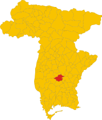
Лестицца (Lestizza, Lestizza)
.svg)
- коммуна Италии
 Hiking in Лестицца
Lestizza is a quaint town located in the Friuli Venezia Giulia region of northeastern Italy. While it might not be as famous as some of Italy's more well-known hiking destinations, it offers a serene environment with potential for lovely hikes in the surrounding countryside.
Hiking Opportunities in and Around Lestizza:
-
Nature Trails: The area around Lestizza boasts several nature trails that wind through lush greenery, farmlands, and peaceful landscapes. These trails can be ideal for casual walkers and families.
-
Gemona del Friuli: A bit further afield, you can visit the town of Gemona del Friuli. The surrounding mountains offer hikes that provide stunning views and a glimpse of the region's natural beauty.
-
Colli Orientali del Friuli: This area is known for its wine production and beautiful vineyards, and there are several trails available for hiking. You can enjoy both a hike and an exploration of the local wineries.
-
Nearby Natural Reserves: The nearby nature reserves, such as the Riserva Naturale Regionale del Lago di Cornino, offer marked trails that showcase local flora and fauna.
Things to Keep in Mind:
-
Trail Difficulty: Make sure to choose trails that match your skill level. In the Friuli Venezia Giulia region, trails can range from easy walks to more strenuous hikes.
-
Weather: The region can have variable weather. Checking the forecast ahead of your hike is advisable.
-
Gear: Wear appropriate footwear and bring plenty of water, snacks, and sun protection, especially during warmer months.
-
Local Information: It may be helpful to stop by local tourist offices for maps and recommendations on the best trails in the area.
In summary, while Lestizza may not be a major hiking hub, it offers access to delightful rural landscapes and nearby hiking opportunities that can provide a refreshing outdoor experience. Enjoy your hike!
- Страна:

- Почтовый код: 33050
- Телефонный код: 0432
- Код автомобильного номера: UD
- Координаты: 45° 57' 0" N, 13° 8' 0" E


- GPS треки (wikiloc): [Ссылка]
- Высота над уровнем моря: 24 м m
- Площадь: 34.32 кв.км
- Население: 3771
- Веб сайт: http://www.comune.lestizza.ud.it/
- Википедия русская: wiki(ru)
- Википедия английская: wiki(en)
- Википедия национальная: wiki(it)
- Хранилище Wikidata: Wikidata: Q53271
- Катеория в википедии: [Ссылка]
- код Freebase: [/m/0gk924]
- код GeoNames: Альт: [6538371]
- код VIAF: Альт: [150074814]
- ID отношения в OpenStreetMap: [79129]
- код GND: Альт: [4759691-0]
- код ISTAT: 030048
- кадастровый код Италии: E553
Граничит с регионами:
Базилиано
- коммуна Италии
Hiking in Базилиано
Basiliano is a charming municipality located in the Friuli Venezia Giulia region of northern Italy. Although it may not be as well-known for hiking as some other areas in Italy, it offers a variety of beautiful landscapes, local trails, and access to the surrounding natural parks and hills. Here are some things to consider for hiking in and around Basiliano:...
- Страна:
- Почтовый код: 33031
- Телефонный код: 0432
- Код автомобильного номера: UD
- Координаты: 46° 1' 0" N, 13° 6' 0" E
- GPS треки (wikiloc): [Ссылка]
- Высота над уровнем моря: 77 м m
- Площадь: 43.05 кв.км
- Население: 5345
- Веб сайт: [Ссылка]


Бертиоло
- коммуна Италии
Hiking in Бертиоло
Bertiolo is a small town located in the Friuli Venezia Giulia region of northeastern Italy. While it might not be as famous as some of the larger towns or cities in Italy, it offers access to beautiful natural landscapes and hiking opportunities....
- Страна:
- Почтовый код: 33032
- Телефонный код: 0432
- Код автомобильного номера: UD
- Координаты: 45° 56' 42" N, 13° 3' 19" E
- GPS треки (wikiloc): [Ссылка]
- Высота над уровнем моря: 33 м m
- Площадь: 26.07 кв.км
- Население: 2423
- Веб сайт: [Ссылка]

Кодройпо
- коммуна Италии
Hiking in Кодройпо
Codroipo, located in the Friuli Venezia Giulia region of northeastern Italy, offers a unique experience for hikers. The area is characterized by a mix of flat plains and gentle hills, making it suitable for hikers of all skill levels. While Codroipo itself may not be a well-known hiking destination, it's surrounded by beautiful landscapes and trails that can appeal to nature lovers....
- Страна:
- Почтовый код: 33033
- Телефонный код: 0432
- Код автомобильного номера: UD
- Координаты: 45° 57' 41" N, 12° 58' 39" E
- GPS треки (wikiloc): [Ссылка]
- Высота над уровнем моря: 43 м m
- Площадь: 75.22 кв.км
- Население: 16165
- Веб сайт: [Ссылка]


Мортельяно
- коммуна Италии
Hiking in Мортельяно
Mortegliano is a quaint town located in the Friuli Venezia Giulia region of northern Italy. While it may not be as widely known for its hiking trails as other areas in the region, it is surrounded by beautiful landscapes and natural scenery that can be explored through various outdoor activities, including hiking....
- Страна:
- Почтовый код: 33050
- Телефонный код: 0432
- Код автомобильного номера: UD
- Координаты: 45° 57' 0" N, 13° 10' 0" E
- GPS треки (wikiloc): [Ссылка]
- Высота над уровнем моря: 41 м m
- Площадь: 30.05 кв.км
- Население: 4969
- Веб сайт: [Ссылка]

Поццуоло-дель-Фриули
- коммуна Италии
Hiking in Поццуоло-дель-Фриули
Pozzuolo del Friuli is a charming municipality located in the Friuli Venezia Giulia region of northeastern Italy. Known for its scenic landscapes and rich cultural heritage, it offers opportunities for outdoor activities, including hiking....
- Страна:
- Почтовый код: 33050
- Телефонный код: 0432
- Код автомобильного номера: UD
- Координаты: 45° 58' 5" N, 13° 11' 49" E
- GPS треки (wikiloc): [Ссылка]
- Высота над уровнем моря: 67 м m
- Площадь: 34.37 кв.км
- Население: 6927
- Веб сайт: [Ссылка]
Тальмассонс
- коммуна Италии
Hiking in Тальмассонс
Talmassons is a charming area located in the Friuli Venezia Giulia region of northeastern Italy, known for its picturesque landscapes, lush vegetation, and serene hiking trails. While it may not be as widely recognized as some other hiking destinations, it offers a unique experience for outdoor enthusiasts....
- Страна:
- Почтовый код: 33030
- Телефонный код: 0432
- Код автомобильного номера: UD
- Координаты: 45° 56' 0" N, 13° 7' 0" E
- GPS треки (wikiloc): [Ссылка]
- Высота над уровнем моря: 30 м m
- Площадь: 43.05 кв.км
- Население: 4045
- Веб сайт: [Ссылка]