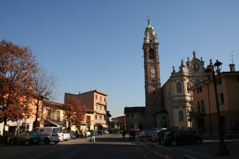
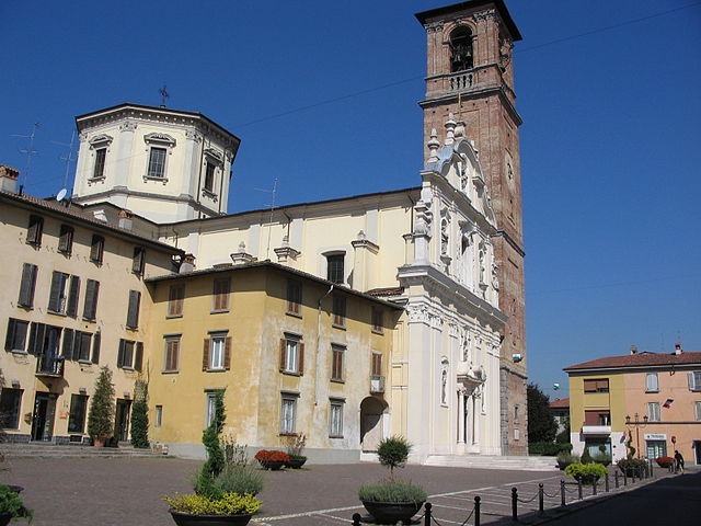
Левате (Levate, Levate)
.svg)
- коммуна Италии
 Hiking in Левате
Levate, located in the province of Bergamo in Northern Italy, offers beautiful landscapes and diverse hiking opportunities. The area is characterized by picturesque rolling hills, charming villages, and lush nature, making it an excellent place for outdoor enthusiasts.
Hiking Trails in Levate
-
Local Trails: There are various local trails around Levate that cater to different skill levels, from easy walks to more challenging hikes. The trails often feature scenic views of the surrounding countryside and the nearby Bergamasque Alps.
-
Sentiero dei Gelsi: This is a popular trail that showcases the local flora and fauna, along with beautiful views. It's relatively easy and is suitable for families and casual hikers.
-
Monte Canto: A nearby peak that can be accessed via a more challenging hike. The trail to Monte Canto offers breathtaking views over the region and is an excellent option for experienced hikers looking for a rewarding experience.
Best Time to Hike
- Spring (March to June): This is one of the best times to hike, as the weather is mild and wildflowers bloom, making the landscape even more beautiful.
- Fall (September to November): Another great time for hiking, with cooler temperatures and stunning autumn foliage.
Safety and Preparation
- Always check the weather forecast before heading out, as conditions can change quickly in mountainous areas.
- Wear appropriate hiking gear, including sturdy footwear and weather-resistant clothing.
- Carry enough water and snacks, especially on longer hikes.
- Inform someone about your hiking plans, especially if you're heading out alone.
Local Attractions
After a day of hiking, consider exploring Levate's local culture, cuisine, and historical sites. The village is known for its quaint charm, with local eateries where you can enjoy traditional Italian dishes.
Conclusion
Whether you are an experienced hiker or just starting, Levate offers a variety of hiking options in a stunning landscape. Prepare adequately and enjoy the beauty of the Italian countryside!
- Страна:

- Почтовый код: 24040
- Телефонный код: 035
- Код автомобильного номера: BG
- Координаты: 45° 38' 0" N, 9° 37' 0" E


- GPS треки (wikiloc): [Ссылка]
- Высота над уровнем моря: 185 м m
- Площадь: 5.53 кв.км
- Население: 3780
- Веб сайт: http://www.comune.levate.bg.it
- Википедия русская: wiki(ru)
- Википедия английская: wiki(en)
- Википедия национальная: wiki(it)
- Хранилище Wikidata: Wikidata: Q101196
- Галерея изображений в википедии: [Ссылка]
- Катеория в википедии: [Ссылка]
- код Freebase: [/m/0gjbvr]
- код GeoNames: Альт: [6543158]
- ID отношения в OpenStreetMap: [45519]
- UN/LOCODE: [ITLEE]
- код ISTAT: 016126
- кадастровый код Италии: E562
Граничит с регионами:


Комун-Нуово
- коммуна Италии
Hiking in Комун-Нуово
Comun Nuovo, located in the Lombardy region of Italy, offers a picturesque setting for hiking enthusiasts. Although it’s a small town, it's surrounded by a beautiful landscape that features a mix of urban and natural environments. Here are some highlights for hiking in and around Comun Nuovo:...
- Страна:
- Почтовый код: 24040
- Телефонный код: 035
- Код автомобильного номера: BG
- Координаты: 45° 37' 22" N, 9° 39' 49" E
- GPS треки (wikiloc): [Ссылка]
- Высота над уровнем моря: 188 м m
- Площадь: 6.45 кв.км
- Население: 4389
- Веб сайт: [Ссылка]


Дальмине
- коммуна Италии
Hiking in Дальмине
Dalmine, located in the Lombardy region of Italy, is primarily an urban area, but it offers access to several nearby natural attractions and hiking opportunities. While Dalmine itself may not have extensive trails directly within the city, there are several options in the surrounding regions....
- Страна:
- Почтовый код: 24044
- Телефонный код: 035
- Код автомобильного номера: BG
- Координаты: 45° 39' 0" N, 9° 36' 0" E
- GPS треки (wikiloc): [Ссылка]
- Высота над уровнем моря: 201 м m
- Площадь: 11.81 кв.км
- Население: 23495
- Веб сайт: [Ссылка]


Озио-Сопра
- коммуна Италии
Hiking in Озио-Сопра
Osio Sopra is a small town in the Lombardy region of Italy, located near Bergamo. While Osio Sopra is primarily an urban area, there are opportunities for hiking and outdoor activities in the surrounding regions. Here are some insights for hiking enthusiasts:...
- Страна:
- Почтовый код: 24040
- Телефонный код: 035
- Код автомобильного номера: BG
- Координаты: 45° 38' 0" N, 9° 35' 0" E
- GPS треки (wikiloc): [Ссылка]
- Высота над уровнем моря: 192 м m
- Площадь: 5.18 кв.км
- Население: 5273
- Веб сайт: [Ссылка]

Озио-Сотто
- коммуна Италии
Hiking in Озио-Сотто
Osio Sotto, located in the Lombardy region of Italy, is not primarily known as a hiking destination, but it does offer some opportunities for outdoor activities and exploration. Its proximity to the larger city of Bergamo and the magnificent landscapes of the nearby Pre-Alps and the Orobie Alps means that there are many hiking trails available not too far from Osio Sotto....
- Страна:
- Почтовый код: 24046
- Телефонный код: 035
- Код автомобильного номера: BG
- Координаты: 45° 37' 0" N, 9° 36' 0" E
- GPS треки (wikiloc): [Ссылка]
- Высота над уровнем моря: 182 м m
- Площадь: 7.59 кв.км
- Население: 12474
- Веб сайт: [Ссылка]


Стеццано
- коммуна Италии
Hiking in Стеццано
Stezzano is a small town located in the Lombardy region of Italy, near Bergamo. While it may not be as widely recognized for hiking compared to more mountainous areas, there are several outdoor opportunities and nearby areas that you can explore....
- Страна:
- Почтовый код: 24040
- Телефонный код: 035
- Код автомобильного номера: BG
- Координаты: 45° 35' 0" N, 9° 40' 0" E
- GPS треки (wikiloc): [Ссылка]
- Высота над уровнем моря: 211 м m
- Площадь: 9.37 кв.км
- Население: 13112
- Веб сайт: [Ссылка]
Верделлино
- коммуна Италии
Hiking in Верделлино
Verdellino is a village located in the Lombardy region of northern Italy, specifically in the province of Bergamo. While Verdellino itself is more urban and suburban in nature, there are several outdoor and hiking opportunities in the surrounding areas, particularly in the nearby hills and mountains....
- Страна:
- Почтовый код: 24040
- Телефонный код: 035
- Код автомобильного номера: BG
- Координаты: 45° 36' 7" N, 9° 36' 32" E
- GPS треки (wikiloc): [Ссылка]
- Высота над уровнем моря: 172 м m
- Площадь: 3.82 кв.км
- Население: 7569
- Веб сайт: [Ссылка]

Верделло
- коммуна Италии
Hiking in Верделло
Verdello is a small town in Italy, located in the Lombardy region, close to the city of Bergamo. While it may not be as famous for hiking as the larger nearby mountain ranges, such as the Orobie Alps, there are still some opportunities for outdoor activities and exploring the natural beauty of the region....
- Страна:
- Почтовый код: 24049
- Телефонный код: 035
- Код автомобильного номера: BG
- Координаты: 45° 36' 18" N, 9° 37' 47" E
- GPS треки (wikiloc): [Ссылка]
- Высота над уровнем моря: 173 м m
- Площадь: 7.34 кв.км
- Население: 8082
- Веб сайт: [Ссылка]