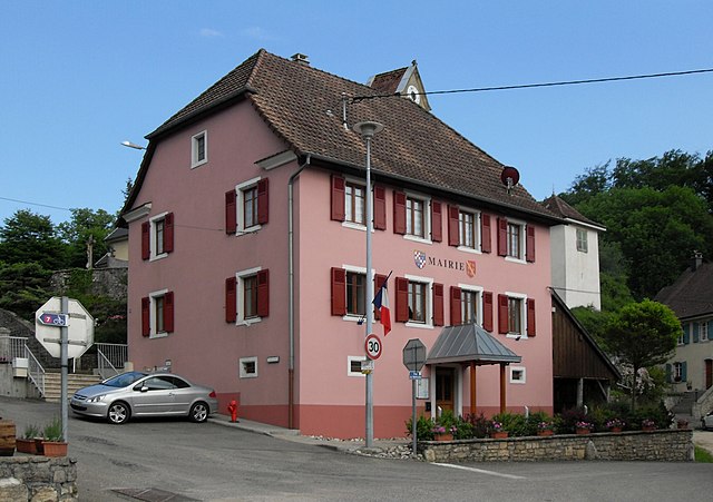
Левонкур (Levoncourt, Levoncourt)

- коммуна во Франции
 Hiking in Левонкур
Levoncourt, located in the Haut-Rhin department of the Alsace region in France, offers a range of hiking opportunities to immerse yourself in the natural beauty of the area. The region is characterized by its picturesque landscapes, rolling hills, and vineyards, making it perfect for outdoor activities.
Hiking Trails:
-
Local Paths: There are several well-marked local trails that vary in difficulty. You can find routes suitable for both beginners and more experienced hikers. The paths often meander through forests, fields, and past charming villages.
-
Vineyard Trails: The Alsace Wine Route is nearby, providing a unique opportunity to hike through vineyards. These trails offer stunning views of the surrounding countryside and the chance to explore local wineries.
-
Natural Reserves: The region is home to several nature reserves and parks, such as the Parc Naturel Régional des Ballons des Vosges, which is slightly further afield. These areas offer more challenging hikes, abundant wildlife, and scenic vistas.
Tips for Hiking in Levoncourt:
-
Seasonal Considerations: The best times for hiking in Alsace are late spring through early autumn when the weather is mild, and the nature is in full bloom. Be cautious of winter conditions, as snow and ice can make trails hazardous.
-
Hydration and Supplies: Always carry enough water, snacks, and a map or GPS device. While many trails are well-marked, it’s good to have a backup.
-
Local Culture: After a day of hiking, take time to explore Levoncourt and the surrounding villages. You can enjoy local cuisine, and perhaps sample some Alsatian wines.
-
Respect Nature: Stay on marked trails, respect the wildlife, and carry out any trash you bring in to help preserve the beauty of the area.
Overall, hiking in Levoncourt is a delightful way to experience the natural beauty and cultural heritage of Alsace. Whether you're looking for a leisurely stroll or a more challenging trek, you'll find something that suits your needs in this charming part of France.
- Страна:

- Почтовый код: 68480
- Координаты: 47° 26' 55" N, 7° 12' 16" E


- GPS треки (wikiloc): [Ссылка]
- Площадь: 5.28 кв.км
- Население: 246
- Википедия русская: wiki(ru)
- Википедия английская: wiki(en)
- Википедия национальная: wiki(fr)
- Хранилище Wikidata: Wikidata: Q125184
- Катеория в википедии: [Ссылка]
- код Freebase: [/m/03nst7h]
- код Freebase: [/m/03nst7h]
- код Freebase: [/m/03nst7h]
- код GeoNames: Альт: [6613710]
- код GeoNames: Альт: [6613710]
- код GeoNames: Альт: [6613710]
- номер SIREN: [216801811]
- номер SIREN: [216801811]
- номер SIREN: [216801811]
- код BNF: [15271883m]
- код BNF: [15271883m]
- код BNF: [15271883m]
- код муниципалитета INSEE: 68181
- код муниципалитета INSEE: 68181
- код муниципалитета INSEE: 68181
Граничит с регионами:
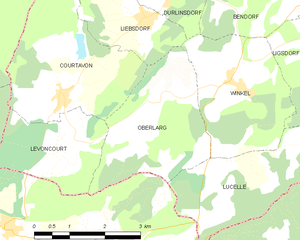
Оберларг
- коммуна во Франции
Hiking in Оберларг
Oberlarg is a charming village situated in the Grand Est region of northeastern France, near the border with Germany. It's surrounded by the scenic landscapes of the Vosges Mountains, making it an ideal destination for hiking enthusiasts. Here are some key points about hiking in and around Oberlarg:...
- Страна:
- Почтовый код: 68480
- Координаты: 47° 27' 27" N, 7° 14' 1" E
- GPS треки (wikiloc): [Ссылка]
- Площадь: 8.21 кв.км
- Население: 138


Куртавон
- коммуна во Франции
Hiking in Куртавон
Courtavon is not widely recognized as a notable hiking destination, so it might be a less explored area. However, if you are interested in hiking in a particular region that includes this name, such as in certain parts of Europe, the experience can vary greatly based on the location....
- Страна:
- Почтовый код: 68480
- Координаты: 47° 27' 38" N, 7° 11' 51" E
- GPS треки (wikiloc): [Ссылка]
- Площадь: 9.6 кв.км
- Население: 370