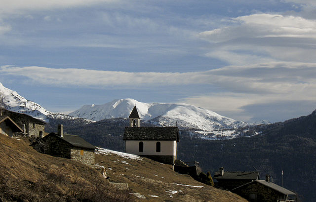
Ловеро (Lovero, Lovero)
.svg)
- коммуна Италии
 Hiking in Ловеро
Lovero is a charming village located in the Valtellina region of northern Italy, offering stunning landscapes and a variety of hiking opportunities. The area is known for its beautiful mountains, lush greenery, and picturesque views that attract outdoor enthusiasts.
Hiking Trails
-
Val di Mello: Close to Lovero, this valley is famous for its breathtaking cliffs and meadows. Popular routes include trails that lead you through lush pine forests and offer views of the granite walls, ideal for both casual hikers and experienced climbers.
-
Sentiero dei Fiori: This trail is renowned for its diverse flora and fauna. Perfect for spring and summer hikes, you can enjoy wildflowers and scenic views along the way.
-
Montalto: A hike to Mont Montalto provides panoramic views of the surrounding valleys. The trail can be steep in sections, so it’s ideal for those looking for a challenge.
-
Rifugio Malghera: This trail leads you to a mountain hut where you can relax and enjoy traditional local cuisine, making it a great spot for a break during your hike.
Tips for Hiking in Lovero
- Preparation: Make sure to check the weather forecast and trail conditions before heading out. The weather can change rapidly in the mountains.
- Gear: Wear sturdy hiking boots and bring essential gear like water, snacks, a first-aid kit, and a map or GPS device.
- Respect Nature: Stay on marked trails, avoid picking plants, and be mindful of wildlife.
- Local Regulations: Some areas may have specific regulations regarding camping or fires, so it’s a good idea to check in advance.
Accessibility
Lovero is accessible by car and is well-connected to other towns in Valtellina. Public transportation options, such as buses, are also available for reaching nearby trailheads.
In summary, hiking in Lovero offers breathtaking views and a variety of trails suitable for different skill levels. Always remember to prepare adequately and respect the natural environment while exploring this beautiful region.
- Страна:

- Почтовый код: 23030
- Телефонный код: 0342
- Код автомобильного номера: SO
- Координаты: 46° 14' 0" N, 10° 14' 0" E


- GPS треки (wikiloc): [Ссылка]
- Высота над уровнем моря: 515 м m
- Площадь: 13.46 кв.км
- Население: 657
- Веб сайт: http://www.comune.lovero.so.it/
- Википедия русская: wiki(ru)
- Википедия английская: wiki(en)
- Википедия национальная: wiki(it)
- Хранилище Wikidata: Wikidata: Q39814
- Катеория в википедии: [Ссылка]
- код Freebase: [/m/0gj36z]
- код GeoNames: Альт: [6543738]
- код VIAF: Альт: [242203865]
- ID отношения в OpenStreetMap: [47028]
- UN/LOCODE: [ITLOO]
- код ISTAT: 014038
- кадастровый код Италии: E705
Граничит с регионами:

Эдоло
- коммуна Италии
Hiking in Эдоло
Edolo is a charming town located in the Brescia province of Lombardy, Italy, surrounded by the stunning landscapes of the Adamello and Tonale mountains. It's an excellent destination for hiking enthusiasts, offering a variety of trails that cater to different skill levels. Here are some highlights of hiking in the Edolo area:...
- Страна:
- Почтовый код: 25048
- Телефонный код: 0364
- Код автомобильного номера: BS
- Координаты: 46° 10' 44" N, 10° 19' 48" E
- GPS треки (wikiloc): [Ссылка]
- Высота над уровнем моря: 720 м m
- Площадь: 88.9 кв.км
- Население: 4564
- Веб сайт: [Ссылка]
Сернио
- коммуна Италии
Hiking in Сернио
Sernio, located in the Italian region of Lombardy, is a charming destination for hiking enthusiasts. While it may not be as well-known as larger national parks, it offers a variety of trails that can cater to different skill levels, from leisurely walks to more challenging hikes....
- Страна:
- Почтовый код: 23030
- Телефонный код: 0342
- Код автомобильного номера: SO
- Координаты: 46° 13' 0" N, 10° 12' 0" E
- GPS треки (wikiloc): [Ссылка]
- Высота над уровнем моря: 632 м m
- Площадь: 9.52 кв.км
- Население: 474
- Веб сайт: [Ссылка]

Вервио
- коммуна Италии
Hiking in Вервио
Vervio is a charming village located in the Valtellina region of northern Italy, which offers beautiful hiking opportunities amidst stunning alpine scenery. Here are some key points about hiking in and around Vervio:...
- Страна:
- Почтовый код: 23030
- Телефонный код: 0342
- Код автомобильного номера: SO
- Координаты: 46° 15' 0" N, 10° 14' 0" E
- GPS треки (wikiloc): [Ссылка]
- Высота над уровнем моря: 549 м m
- Площадь: 12.41 кв.км
- Население: 209
- Веб сайт: [Ссылка]


Тово-ди-Сант'Агата
- коммуна Италии
Hiking in Тово-ди-Сант'Агата
Tovo di Sant'Agata is a charming village located in the province of Savona, in the Liguria region of Italy. This area is known for its beautiful landscapes, lush Mediterranean vegetation, and diverse hiking opportunities. Here’s what you might want to know about hiking in and around Tovo di Sant'Agata:...
- Страна:
- Почтовый код: 23030
- Телефонный код: 0342
- Код автомобильного номера: SO
- Координаты: 46° 15' 0" N, 10° 15' 0" E
- GPS треки (wikiloc): [Ссылка]
- Высота над уровнем моря: 531 м m
- Площадь: 11.15 кв.км
- Население: 631
- Веб сайт: [Ссылка]