
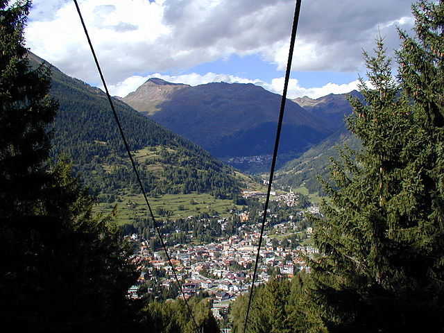
Эдоло (Edolo, Edolo)
.svg)
- коммуна Италии
 Hiking in Эдоло
Edolo is a charming town located in the Brescia province of Lombardy, Italy, surrounded by the stunning landscapes of the Adamello and Tonale mountains. It's an excellent destination for hiking enthusiasts, offering a variety of trails that cater to different skill levels. Here are some highlights of hiking in the Edolo area:
Scenic Trails
-
Sentiero del Bosco: This trail meanders through lush forests and provides stunning views. It’s suitable for families and beginners.
-
Corno dei Tre Signori: A more challenging hike that rewards you with panoramic views of the surrounding peaks. It’s ideal for more experienced hikers looking for a rewarding day out.
-
Val Camonica: Just a short distance from Edolo, this area offers numerous trails that showcase the valley's natural beauty and prehistoric rock carvings.
Natural Attractions
-
Adamello National Park: A vast area known for its glaciers, alpine lakes, and diverse wildlife. The park includes several well-marked trails, making it accessible for day hikes.
-
Lago di Mortirolo: A picturesque lake that can be reached via a moderate hike. The area around the lake is perfect for a picnic and offers serene views.
Practical Tips
-
Best Time to Hike: The ideal hiking season runs from late spring to early autumn (May to October) when the weather is milder and trails are accessible.
-
Equipment: Good hiking boots, weather-appropriate clothing, and plenty of water are essential. Always check local weather conditions before setting out.
-
Maps and Guides: It’s recommended to have a detailed map of the area or a guidebook, as some trails may not be well-marked.
-
Local Resources: Visitors can find information at local tourist offices, which can provide updates on trail conditions and recommendations for less-known routes.
Whether you’re looking for a leisurely stroll or a strenuous hike, Edolo has something to offer everyone. Enjoy your time exploring the natural beauty of this remarkable region in Italy!
- Страна:

- Почтовый код: 25048
- Телефонный код: 0364
- Код автомобильного номера: BS
- Координаты: 46° 10' 44" N, 10° 19' 48" E


- GPS треки (wikiloc): [Ссылка]
- Высота над уровнем моря: 720 м m
- Площадь: 88.9 кв.км
- Население: 4564
- Веб сайт: http://www.comune.edolo.bs.it
- Википедия русская: wiki(ru)
- Википедия английская: wiki(en)
- Википедия национальная: wiki(it)
- Хранилище Wikidata: Wikidata: Q104585
- Галерея изображений в википедии: [Ссылка]
- Катеория в википедии: [Ссылка]
- код Freebase: [/m/041wr9]
- код GeoNames: Альт: [6537169]
- код VIAF: Альт: [243073220]
- ID отношения в OpenStreetMap: [46954]
- место в MusicBrainz: [a5abcb58-4f33-4ae1-9ea0-005d9c7369bb]
- UN/LOCODE: [ITEDL]
- код ISTAT: 017068
- кадастровый код Италии: D391
Граничит с регионами:

Кортено-Гольджи
- коммуна Италии
Hiking in Кортено-Гольджи
Corteno Golgi is a charming village located in the Lombardy region of Italy, nestled in the heart of the Central Alps. It's a great destination for hiking enthusiasts, offering a mix of beautiful landscapes, historical sites, and well-marked trails....
- Страна:
- Почтовый код: 25040
- Телефонный код: 0364
- Код автомобильного номера: BS
- Координаты: 46° 10' 1" N, 10° 14' 40" E
- GPS треки (wikiloc): [Ссылка]
- Высота над уровнем моря: 925 м m
- Площадь: 82.61 кв.км
- Население: 1962
- Веб сайт: [Ссылка]

Инкудине
- коммуна Италии
Hiking in Инкудине
Incudine is a small and picturesque village located in the province of Brescia in the Lombardy region of Italy, nestled in the scenic Valle Camonica. Hiking in this area offers stunning views of the surrounding mountains, lush forests, and opportunities to explore rich cultural heritage....
- Страна:
- Почтовый код: 25040
- Телефонный код: 0364
- Код автомобильного номера: BS
- Координаты: 46° 13' 20" N, 10° 21' 30" E
- GPS треки (wikiloc): [Ссылка]
- Высота над уровнем моря: 910 м m
- Площадь: 19.67 кв.км
- Население: 371
- Веб сайт: [Ссылка]

Малонно
- коммуна Италии
Hiking in Малонно
Malonno, located in the beautiful region of Lombardy, Italy, is known for its stunning landscapes and natural beauty, making it a great destination for hiking enthusiasts. Nestled in the Camonica Valley, this area offers a range of trails that cater to different skill levels, from easy walks to more challenging hikes....
- Страна:
- Почтовый код: 25040
- Телефонный код: 0364
- Код автомобильного номера: BS
- Координаты: 46° 7' 0" N, 10° 19' 0" E
- GPS треки (wikiloc): [Ссылка]
- Высота над уровнем моря: 596 м m
- Площадь: 31.46 кв.км
- Население: 3183
- Веб сайт: [Ссылка]

Монно
- коммуна Италии
Hiking in Монно
Monno, located in the province of Brescia in Italy, is an excellent destination for hiking enthusiasts. Nestled in the beautiful landscape of the Lombardy region, it offers a variety of trails suitable for different skill levels, from leisurely walks to more challenging hikes....
- Страна:
- Почтовый код: 25040
- Телефонный код: 0364
- Код автомобильного номера: BS
- Координаты: 46° 12' 48" N, 10° 20' 26" E
- GPS треки (wikiloc): [Ссылка]
- Высота над уровнем моря: 1066 м m
- Площадь: 31.03 кв.км
- Население: 540
- Веб сайт: [Ссылка]
Понте-ди-Леньо
- коммуна Италии
Hiking in Понте-ди-Леньо
Ponte di Legno is a beautiful alpine resort located in the Lombardy region of northern Italy, nestled within the stunning landscape of the Adamello-Presanella Natural Park. This area is renowned for its breathtaking mountain scenery, diverse flora and fauna, and a variety of hiking trails suitable for all levels of hikers....
- Страна:
- Почтовый код: 25056
- Телефонный код: 0364
- Код автомобильного номера: BS
- Координаты: 46° 15' 34" N, 10° 30' 34" E
- GPS треки (wikiloc): [Ссылка]
- Высота над уровнем моря: 1258 м m
- Площадь: 100.43 кв.км
- Население: 1730
- Веб сайт: [Ссылка]

Савьоре-делл'Адамелло
- коммуна Италии
Hiking in Савьоре-делл'Адамелло
Saviore dell'Adamello is a charming village located in the Italian Alps, specifically in the Lombardy region of Italy. It serves as a gateway to the Adamello-Brenta Natural Park, a stunning area rich in biodiversity, with picturesque landscapes, rugged mountains, crystal-clear lakes, and lush forests, making it a great destination for hiking enthusiasts....
- Страна:
- Почтовый код: 25050
- Телефонный код: 0364
- Код автомобильного номера: BS
- Координаты: 46° 4' 50" N, 10° 23' 54" E
- GPS треки (wikiloc): [Ссылка]
- Высота над уровнем моря: 1100 м m
- Площадь: 84.27 кв.км
- Население: 886
- Веб сайт: [Ссылка]

Сонико
- коммуна Италии
Hiking in Сонико
Sonico, a charming town in the province of Brescia in Lombardy, is nestled in the picturesque Val Camonica, which offers numerous hiking opportunities for outdoor enthusiasts. The region is known for its stunning landscapes, including mountains, lush valleys, and historical sites, making it a perfect destination for hikers of all levels....
- Страна:
- Почтовый код: 25048
- Телефонный код: 0364
- Код автомобильного номера: BS
- Координаты: 46° 9' 59" N, 10° 21' 14" E
- GPS треки (wikiloc): [Ссылка]
- Высота над уровнем моря: 650 м m
- Площадь: 60.89 кв.км
- Население: 1265
- Веб сайт: [Ссылка]

Тему
- коммуна Италии
Hiking in Тему
Temù is a charming town located in the Val Camonica region of northern Italy, nestled in the foothills of the Adamello-Presanella Alps. It's a great destination for hiking enthusiasts, offering a variety of trails and scenic landscapes....
- Страна:
- Почтовый код: 25050
- Телефонный код: 0364
- Код автомобильного номера: BS
- Координаты: 46° 14' 58" N, 10° 28' 8" E
- GPS треки (wikiloc): [Ссылка]
- Высота над уровнем моря: 1150 м m
- Площадь: 43.26 кв.км
- Население: 1105
- Веб сайт: [Ссылка]

Вионе
- коммуна Италии
Hiking in Вионе
Vione, a charming village in the Lombardy region of Italy, serves as a great starting point for hiking adventures, especially in the nearby Valcamonica area. The region offers breathtaking landscapes, including rolling hills, lush forests, alpine meadows, and stunning views of the surrounding mountains....
- Страна:
- Почтовый код: 25050
- Телефонный код: 0364
- Код автомобильного номера: BS
- Координаты: 46° 14' 53" N, 10° 26' 54" E
- GPS треки (wikiloc): [Ссылка]
- Высота над уровнем моря: 1250 м m
- Площадь: 35.27 кв.км
- Население: 689
- Веб сайт: [Ссылка]
Сернио
- коммуна Италии
Hiking in Сернио
Sernio, located in the Italian region of Lombardy, is a charming destination for hiking enthusiasts. While it may not be as well-known as larger national parks, it offers a variety of trails that can cater to different skill levels, from leisurely walks to more challenging hikes....
- Страна:
- Почтовый код: 23030
- Телефонный код: 0342
- Код автомобильного номера: SO
- Координаты: 46° 13' 0" N, 10° 12' 0" E
- GPS треки (wikiloc): [Ссылка]
- Высота над уровнем моря: 632 м m
- Площадь: 9.52 кв.км
- Население: 474
- Веб сайт: [Ссылка]


Тово-ди-Сант'Агата
- коммуна Италии
Hiking in Тово-ди-Сант'Агата
Tovo di Sant'Agata is a charming village located in the province of Savona, in the Liguria region of Italy. This area is known for its beautiful landscapes, lush Mediterranean vegetation, and diverse hiking opportunities. Here’s what you might want to know about hiking in and around Tovo di Sant'Agata:...
- Страна:
- Почтовый код: 23030
- Телефонный код: 0342
- Код автомобильного номера: SO
- Координаты: 46° 15' 0" N, 10° 15' 0" E
- GPS треки (wikiloc): [Ссылка]
- Высота над уровнем моря: 531 м m
- Площадь: 11.15 кв.км
- Население: 631
- Веб сайт: [Ссылка]


Ловеро
- коммуна Италии
Hiking in Ловеро
Lovero is a charming village located in the Valtellina region of northern Italy, offering stunning landscapes and a variety of hiking opportunities. The area is known for its beautiful mountains, lush greenery, and picturesque views that attract outdoor enthusiasts....
- Страна:
- Почтовый код: 23030
- Телефонный код: 0342
- Код автомобильного номера: SO
- Координаты: 46° 14' 0" N, 10° 14' 0" E
- GPS треки (wikiloc): [Ссылка]
- Высота над уровнем моря: 515 м m
- Площадь: 13.46 кв.км
- Население: 657
- Веб сайт: [Ссылка]

Вецца-д'Ольо
- коммуна Италии
Hiking in Вецца-д'Ольо
Vezza d'Oglio is a charming town located in the Camonica Valley in the Lombardy region of northern Italy. It serves as a gateway to numerous hiking opportunities in the surrounding areas. Here are some highlights and tips for hiking around Vezza d'Oglio:...
- Страна:
- Почтовый код: 25059
- Телефонный код: 0364
- Код автомобильного номера: BS
- Координаты: 46° 14' 20" N, 10° 23' 53" E
- GPS треки (wikiloc): [Ссылка]
- Высота над уровнем моря: 1080 м m
- Площадь: 54.15 кв.км
- Население: 1443
- Веб сайт: [Ссылка]