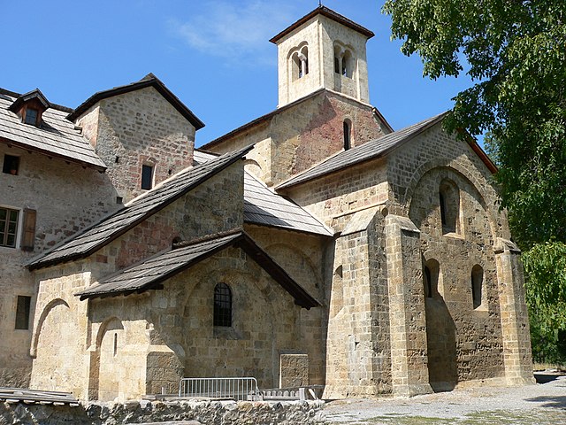
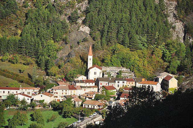
Меолан-Ревель (Méolans-Revel, Méolans-Revel)
- коммуна во Франции
 Hiking in Меолан-Ревель
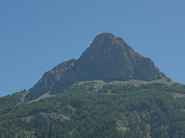
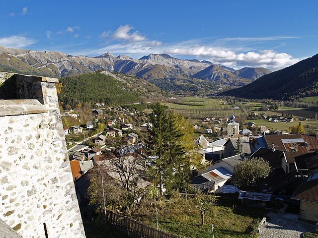
Méolans-Revel is a charming commune located in the Alpes-de-Haute-Provence region of southeastern France, known for its beautiful landscapes and outdoor recreational opportunities. Here’s an overview of hiking in this area:
Scenic Trails
-
Diverse Terrain: The region offers a mix of terrain, including lush valleys, rugged mountains, and pristine forests. Hikers can enjoy the breathtaking views of the surrounding peaks, including the nearby Barcelonnette Valley and the Mercantour National Park.
-
Variety of Trails: There are various hiking trails suitable for all skill levels, from gentle strolls to more challenging hikes. Trails are often well-marked, making navigation easier for both seasoned hikers and beginners.
Notable Hikes
-
GR 56 Trail: This trail traverses the Ubaye Valley and offers stunning views of mountains and valleys, integrating history and nature.
-
Local Paths: There are several shorter circuits around Méolans-Revel that allow hikers to soak in the beauty of the area without committing to a full day hike.
Flora and Fauna
- Biodiversity: The region is known for its rich biodiversity, with various species of plants and animals. Keep an eye out for local wildlife, including deer, chamois, and various bird species.
Practical Tips
-
Best Time to Hike: The ideal time for hiking in Méolans-Revel is between late spring and early autumn, when the weather is generally favorable and the trails are more accessible.
-
Safety: Always check the weather conditions before heading out, and be prepared with the appropriate gear, including good hiking boots, a map, and plenty of water.
-
Local Regulations: Be mindful of local regulations and guidelines, especially in protected areas such as national parks.
-
Guided Tours: For those unfamiliar with the area or wanting a more in-depth experience, consider joining a guided hiking tour that can provide insights into the local ecology and history.
Amenities
-
Accommodations: There are several options for accommodations, from rustic lodges to more modern hotels in the area, making it easy to find a place to stay after a day of hiking.
-
Local Cuisine: Don’t miss the chance to try local specialties after your hikes; the region is known for its delicious cuisine, including fresh mountain fare.
Overall, hiking in Méolans-Revel offers a wonderful opportunity to experience the natural beauty of the French Alps while enjoying outdoor activities.
- Страна:

- Почтовый код: 04340
- Координаты: 44° 24' 5" N, 6° 30' 42" E


- GPS треки (wikiloc): [Ссылка]
- Высота над уровнем моря: 1040 м m
- Площадь: 127.74 кв.км
- Население: 337
- Википедия русская: wiki(ru)
- Википедия английская: wiki(en)
- Википедия национальная: wiki(fr)
- Хранилище Wikidata: Wikidata: Q1018637
- Катеория в википедии: [Ссылка]
- код Freebase: [/m/03m7wwn]
- код Freebase: [/m/03m7wwn]
- код GeoNames: Альт: [2994490]
- код GeoNames: Альт: [2994490]
- номер SIREN: [210401618]
- номер SIREN: [210401618]
- Territographie ID: [271]
- Territographie ID: [271]
- код муниципалитета INSEE: 04161
- код муниципалитета INSEE: 04161
Граничит с регионами:
Кро
- коммуна во Франции
Hiking in Кро
Crots, located in the French Alps within the Hautes-Alpes department, is a beautiful destination for hiking enthusiasts. The area is known for its stunning landscapes, including mountains, valleys, and picturesque villages. If you're planning a hiking trip in Crots, here are some key points to consider:...
- Страна:
- Почтовый код: 05200
- Координаты: 44° 32' 1" N, 6° 28' 16" E
- GPS треки (wikiloc): [Ссылка]
- Высота над уровнем моря: 790 м m
- Площадь: 53.84 кв.км
- Население: 1022

Ле-Тюиль
- коммуна во Франции
Hiking in Ле-Тюиль
Les Thuiles is a picturesque village located in the French region of Provence-Alpes-Côte d'Azur, specifically in the Alpes-de-Haute-Provence department. Hiking in this area offers a wonderful experience, as it is surrounded by stunning natural landscapes, including mountains, valleys, and forests....
- Страна:
- Почтовый код: 04400
- Координаты: 44° 23' 35" N, 6° 34' 16" E
- GPS треки (wikiloc): [Ссылка]
- Площадь: 32.8 кв.км
- Население: 398
Юверне-Фур
- коммуна во Франции
Hiking in Юверне-Фур
Uvernet-Fours is a charming destination in the French Alpes-de-Haute-Provence region, known for its beautiful landscapes and outdoor recreational opportunities, including hiking. Here are some details to help you plan your hiking experience in this area:...
- Страна:
- Почтовый код: 04400
- Координаты: 44° 21' 40" N, 6° 37' 34" E
- GPS треки (wikiloc): [Ссылка]
- Площадь: 135.44 кв.км
- Население: 583

Ле-Верне
- коммуна в департаменте Альпы Верхнего Прованса, Франция
Hiking in Ле-Верне
Le Vernet, located in the Alpes-de-Haute-Provence region of France, offers a beautiful setting for hiking enthusiasts. This area is characterized by its stunning alpine landscapes, diverse flora and fauna, and a variety of trails that cater to different skill levels....
- Страна:
- Почтовый код: 04140
- Координаты: 44° 16' 34" N, 6° 23' 27" E
- GPS треки (wikiloc): [Ссылка]
- Площадь: 23.05 кв.км
- Население: 130
Пра-От-Блеон
- коммуна во Франции
Hiking in Пра-От-Блеон
Prads-Haute-Bléone, located in the Alpes-de-Haute-Provence region of France, is a beautiful area for hiking enthusiasts, offering a diverse range of landscapes, from lush valleys to stunning mountain vistas. Here are some highlights and tips for hiking in this region:...
- Страна:
- Почтовый код: 04390
- Координаты: 44° 13' 12" N, 6° 26' 36" E
- GPS треки (wikiloc): [Ссылка]
- Площадь: 165.64 кв.км
- Население: 186
- Веб сайт: [Ссылка]

Лез-Ор
- коммуна во Франции
Hiking in Лез-Ор
Les Orres, located in the French Alps, is a fantastic destination for hiking enthusiasts. This charming mountain resort offers a variety of trails suitable for all levels, from beginners to experienced hikers. Here’s an overview to help you plan your hiking experience in Les Orres:...
- Страна:
- Почтовый код: 05200
- Координаты: 44° 30' 50" N, 6° 33' 3" E
- GPS треки (wikiloc): [Ссылка]
- Высота над уровнем моря: 1460 м m
- Площадь: 74.79 кв.км
- Население: 569
- Веб сайт: [Ссылка]

Ле-Лозе-Юбей
- коммуна во Франции
Hiking in Ле-Лозе-Юбей
Le Lauzet-Ubaye is a beautiful destination located in the Alpes-de-Haute-Provence region of southeastern France. Situated along the Ubaye River, this picturesque area offers stunning landscapes, rich biodiversity, and a variety of hiking trails suitable for different skill levels. Here are some highlights and tips for hiking in Le Lauzet-Ubaye:...
- Страна:
- Почтовый код: 04340
- Координаты: 44° 25' 48" N, 6° 25' 56" E
- GPS треки (wikiloc): [Ссылка]
- Площадь: 66.26 кв.км
- Население: 211
Сен
- коммуна во Франции
Hiking in Сен
Seyne is a delightful town located in the Alpes-de-Haute-Provence region of France, and it offers a variety of hiking opportunities for outdoor enthusiasts. The surrounding landscape is characterized by stunning mountains, lush valleys, and picturesque views, making it an excellent destination for hikers of all skill levels....
- Страна:
- Почтовый код: 04140
- Координаты: 44° 21' 2" N, 6° 21' 23" E
- GPS треки (wikiloc): [Ссылка]
- Площадь: 84.27 кв.км
- Население: 1360
- Веб сайт: [Ссылка]

Алло
Hiking in Алло
Allos is a fantastic destination for hiking, situated in the Alpes-de-Haute-Provence region of France. Known for its stunning natural landscapes and diverse terrain, Allos offers a variety of trails suitable for hikers of all levels. Here are some highlights of hiking in the Allos area:...
- Страна:
- Почтовый код: 04260
- Координаты: 44° 14' 25" N, 6° 37' 41" E
- GPS треки (wikiloc): [Ссылка]
- Площадь: 116.65 кв.км
- Население: 697