Майя (Maillat, Maillat)
- коммуна во Франции
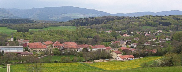
 Hiking in Майя
Maillat is a charming village located in the Rhône-Alpes region of France, known for its beautiful natural landscapes and outdoor activities, including hiking. While the area may not be as widely recognized as some major hiking destinations in the French Alps, it offers a range of trails suitable for hikers of different skill levels.
Hiking in Maillat: What to Expect
-
Scenic Trails: The trails around Maillat typically feature stunning views of the surrounding countryside, forests, and mountains. You can expect a diverse landscape that includes rolling hills, picturesque fields, and quaint village scenery.
-
Trail Difficulty: There are various trails with different levels of difficulty. Beginners can find easy walks that require minimal effort, while more experienced hikers may seek out challenging paths that offer steeper inclines or longer distances.
-
Wildlife and Flora: The area is rich in biodiversity. As you hike, keep an eye out for various species of birds, mammals, and unique plant life. The changing seasons also offer a different experience throughout the year, from blossoming flowers in spring to vibrant fall foliage.
-
Local Culture: Hiking in Maillat is not just about the trails; it's also an opportunity to immerse yourself in the local culture. Along the way, you can visit small farms, sample local produce, and enjoy the hospitality of the village.
-
Guided Tours: If you're new to the area or hiking in general, consider joining a guided tour. Local guides can offer insights into the best trails, the history of the region, and tips on safety.
Recommended Hiking Tips
- Check Trail Conditions: Before heading out, check for any trail updates or advisories.
- Proper Gear: Ensure you wear suitable hiking shoes, and bring plenty of water, snacks, and sun protection, especially if you're hiking in the summer months.
- Know Your Limits: Choose trails that match your fitness level and experience. It’s better to start with easier routes than to overexert yourself.
Conclusion
Maillat may not be on every hiker's radar, but it offers a beautiful and peaceful hiking experience for those seeking to enjoy the outdoors away from the busy tourist spots. Whether you're looking for a leisurely walk or a challenging hike, you'll find plenty to explore in this picturesque part of France.
- Страна:

- Почтовый код: 01430
- Координаты: 46° 7' 45" N, 5° 32' 17" E


- GPS треки (wikiloc): [Ссылка]
- Площадь: 11.31 кв.км
- Население: 633
- Веб сайт: http://www.maillat.fr
- Википедия русская: wiki(ru)
- Википедия английская: wiki(en)
- Википедия национальная: wiki(fr)
- Хранилище Wikidata: Wikidata: Q326806
- Катеория в википедии: [Ссылка]
- Карты в википедии: [Ссылка]
- код Freebase: [/m/03h3s8z]
- код Freebase: [/m/03h3s8z]
- код GeoNames: Альт: [6424577]
- код GeoNames: Альт: [6424577]
- номер SIREN: [210102281]
- номер SIREN: [210102281]
- код муниципалитета INSEE: 01228
- код муниципалитета INSEE: 01228
Граничит с регионами:

Кондамин
- коммуна во Франции
Hiking in Кондамин
Condamine, a small commune located in the Ain department of France, offers a variety of scenic hiking opportunities that showcase the beautiful landscapes of the region. The surrounding countryside features rolling hills, forests, and picturesque views, making it a great destination for outdoor enthusiasts....
- Страна:
- Почтовый код: 01430
- Координаты: 46° 6' 32" N, 5° 33' 4" E
- GPS треки (wikiloc): [Ссылка]
- Площадь: 4.64 кв.км
- Население: 415
- Веб сайт: [Ссылка]

Вьё-д’Изнав
- коммуна во Франции
Hiking in Вьё-д’Изнав
Vieu-d'Izenave is a charming alpine village nestled in the Ain department of the Auvergne-Rhône-Alpes region in France. It offers numerous hiking opportunities thanks to its picturesque landscapes and proximity to the Jura Mountains....
- Страна:
- Почтовый код: 01430
- Координаты: 46° 4' 51" N, 5° 31' 45" E
- GPS треки (wikiloc): [Ссылка]
- Площадь: 23.73 кв.км
- Население: 691
- Веб сайт: [Ссылка]

Сен-Мартен-дю-Френ
- коммуна во Франции
Hiking in Сен-Мартен-дю-Френ
Saint-Martin-du-Frêne, located in the Ain department of the Auvergne-Rhône-Alpes region in France, offers a variety of beautiful hiking opportunities set against the backdrop of the stunning Jura Mountains. The area is recognized for its picturesque landscapes, lush forests, and diverse wildlife, making it an excellent destination for outdoor enthusiasts....
- Страна:
- Почтовый код: 01430
- Координаты: 46° 8' 20" N, 5° 33' 9" E
- GPS треки (wikiloc): [Ссылка]
- Площадь: 19.14 кв.км
- Население: 1076
- Веб сайт: [Ссылка]

Шевийар
- коммуна во Франции
Hiking in Шевийар
Chevillard is a small commune located in the Ain department in the Auvergne-Rhône-Alpes region of southeastern France. Known for its picturesque landscapes, Chevillard offers a variety of hiking opportunities that cater to different skill levels. Here are some key points to consider when hiking in and around Chevillard:...
- Страна:
- Почтовый код: 01430
- Координаты: 46° 6' 34" N, 5° 34' 55" E
- GPS треки (wikiloc): [Ссылка]
- Площадь: 6.67 кв.км
- Население: 156
Пейрья
- коммуна во Франции
Hiking in Пейрья
Peyriat is a lesser-known hiking destination, so details may vary depending on the specific area you’re referring to, as there might be various trails, landscapes, and attractions. However, if you are looking for a hiking experience in the region around Peyriat, here are some general tips and information:...
- Страна:
- Почтовый код: 01430
- Координаты: 46° 9' 15" N, 5° 30' 37" E
- GPS треки (wikiloc): [Ссылка]
- Площадь: 5.96 кв.км
- Население: 171

Лабальм
- коммуна во Франции
Hiking in Лабальм
Labalme does not appear to be a widely recognized hiking destination as of my last update in October 2023. It’s possible that it is a local spot or a lesser-known area that has developed since then. However, if you meant a region like the Alps (which is often associated with hiking) or another popular hiking area, I can provide information about hiking in those locations....
- Страна:
- Почтовый код: 01450
- Координаты: 46° 5' 35" N, 5° 28' 59" E
- GPS треки (wikiloc): [Ссылка]
- Площадь: 8.8 кв.км
- Население: 214

Сень
- коммуна во Франции, департамент Эн
Hiking in Сень
Ceignes is a picturesque area that attracts hikers with its stunning landscapes, diverse trails, and natural beauty. Located in the Jura region of France, it offers a variety of hiking opportunities for all skill levels. Here are some highlights for hiking in Ceignes:...
- Страна:
- Почтовый код: 01430
- Координаты: 46° 7' 13" N, 5° 29' 57" E
- GPS треки (wikiloc): [Ссылка]
- Площадь: 10.01 кв.км
- Население: 256