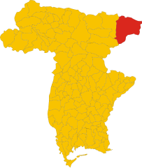
Мальборгетто-Вальбруна (Malborghetto Valbruna, Malborghetto-Valbruna)
.svg)
- коммуна Италии
 Hiking in Мальборгетто-Вальбруна
Malborghetto Valbruna is a picturesque village located in the Valcanale region of northeastern Italy, close to the Austrian border. It is surrounded by stunning Alpine scenery and offers a variety of hiking opportunities for all skill levels. Here are some highlights and tips for hiking in this area:
Scenic Trails
-
Path of the Alps (Sentiero delle Alpi): This trail offers breathtaking views and takes you through lush forests and alpine meadows. It connects several villages in the region, making it perfect for multi-day hikes if you're up for it.
-
Pramollo Lake (Lago Pramollo): A relatively easy hike will take you to this beautiful mountain lake, ideal for a picnic and enjoying the serene landscape. The surrounding hills offer additional trails with varying difficulty.
-
The Val Saisera: This trail winds through a picturesque valley, showcasing beautiful views of the surrounding mountains, including the Julian Alps.
-
Monte Canin: For those looking for a more challenging hike, the route up Monte Canin will reward you with spectacular views.
Preparing for Your Hike
- Check the Weather: Conditions in the mountains can change rapidly, so be sure to check the forecast before setting out.
- Wear Appropriate Gear: Good hiking boots, comfortable clothing, and layering for temperature changes are essential.
- Stay Hydrated: Carry sufficient water, especially on longer hikes where water sources may be sparse.
Enjoying the Environment
- Wildlife Viewing: The region is rich in biodiversity, so keep an eye out for local wildlife, including deer, chamois, and various bird species.
- Flora: In the summer months, you’ll also find a variety of wildflowers and unique alpine plants.
Local Culture
As you hike in the Malborghetto Valbruna area, take the opportunity to experience local culture. The village has charming architecture, traditional Alpine restaurants, and shops where you can taste local foods and crafts.
Safety Tips
- Inform Someone of Your Plans: Always let someone know your hiking route and expected return time.
- Map and Navigation: Bring a physical map or a GPS device, as some trails may not be well-marked.
Hiking in Malborghetto Valbruna can be a rewarding experience with its combination of natural beauty, recreational activities, and cultural experiences. Enjoy your hike!
- Страна:

- Почтовый код: 33010
- Телефонный код: 0428
- Код автомобильного номера: UD
- Координаты: 46° 30' 24" N, 13° 26' 22" E


- GPS треки (wikiloc): [Ссылка]
- Высота над уровнем моря: 721 м m
- Площадь: 124.21 кв.км
- Население: 919
- Веб сайт: http://www.comune.malborghetto-valbruna.ud.it
- Википедия русская: wiki(ru)
- Википедия английская: wiki(en)
- Википедия национальная: wiki(it)
- Хранилище Wikidata: Wikidata: Q53278
- Галерея изображений в википедии: [Ссылка]
- Катеория в википедии: [Ссылка]
- код Freebase: [/m/0gk95v]
- код GeoNames: Альт: [6536247]
- код VIAF: Альт: [233926669]
- ID отношения в OpenStreetMap: [79262]
- код LCNAF: Альт: [n2015000229]
- код ISTAT: 030054
- кадастровый код Италии: E847
Граничит с регионами:

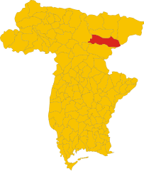
Тарвизио
- коммуна Италии
Hiking in Тарвизио
Tarvisio, located in the northeastern part of Italy near the borders with Austria and Slovenia, is a beautiful destination for hiking enthusiasts. It is situated in the Julian Alps and offers a wide range of trails that cater to various skill levels, from easy strolls to challenging treks. Here are some highlights of hiking in Tarvisio:...
- Страна:
- Почтовый код: 33018
- Телефонный код: 0428
- Код автомобильного номера: UD
- Координаты: 46° 30' 0" N, 13° 34' 0" E
- GPS треки (wikiloc): [Ссылка]
- Высота над уровнем моря: 754 м m
- Площадь: 208.36 кв.км
- Население: 4224
- Веб сайт: [Ссылка]

Кьюзафорте
- коммуна Италии
Hiking in Кьюзафорте
Chiusaforte, located in the Friuli Venezia Giulia region of Italy, is a great destination for hiking enthusiasts. Nestled in the Julian Alps, this area offers a stunning landscape characterized by towering mountains, lush valleys, and clear rivers....
- Страна:
- Почтовый код: 33010
- Телефонный код: 0433
- Код автомобильного номера: UD
- Координаты: 46° 24' 0" N, 13° 19' 0" E
- GPS треки (wikiloc): [Ссылка]
- Высота над уровнем моря: 391 м m
- Площадь: 100.2 кв.км
- Население: 628
- Веб сайт: [Ссылка]


Донья
- коммуна Италии
Hiking in Донья
Dogna is a small town located in the Friuli Venezia Giulia region of northeastern Italy, nestled in the Julian Alps. It's known for its beautiful landscapes and outdoor recreational opportunities, including hiking. Here are some key points to consider if you're planning a hiking trip in the Dogna area:...
- Страна:
- Почтовый код: 33010
- Телефонный код: 0428
- Код автомобильного номера: UD
- Координаты: 46° 26' 53" N, 13° 18' 54" E
- GPS треки (wikiloc): [Ссылка]
- Высота над уровнем моря: 430 м m
- Площадь: 70.37 кв.км
- Население: 168
- Веб сайт: [Ссылка]


Понтебба
- коммуна Италии
Hiking in Понтебба
Pontebba, located in the Friuli Venezia Giulia region of northeastern Italy, is a fantastic destination for hiking enthusiasts. Nestled at the foot of the Julian Alps, it offers stunning landscapes, a variety of trails, and rich natural and cultural heritage....
- Страна:
- Почтовый код: 33016
- Телефонный код: 0428
- Код автомобильного номера: UD
- Координаты: 46° 30' 0" N, 13° 19' 0" E
- GPS треки (wikiloc): [Ссылка]
- Высота над уровнем моря: 568 м m
- Площадь: 99.66 кв.км
- Население: 1397
- Веб сайт: [Ссылка]

Хоэнтурн
Hiking in Хоэнтурн
Hohenthurn, a small village in Austria located near the border with Slovenia, is surrounded by beautiful natural landscapes that offer various hiking opportunities. The area is characterized by scenic views, lush forests, and the picturesque backdrop of the Julian Alps....
- Страна:

- Почтовый код: 9613
- Телефонный код: 0 42 56
- Код автомобильного номера: VL
- Координаты: 46° 33' 24" N, 13° 39' 33" E
- GPS треки (wikiloc): [Ссылка]
- Высота над уровнем моря: 620 м m
- Площадь: 27.16 кв.км
- Население: 851
- Веб сайт: [Ссылка]

Санкт-Штефан-им-Гайльталь
Hiking in Санкт-Штефан-им-Гайльталь
Sankt Stefan im Gailtal, located in the picturesque Gail Valley in Austria, is a fantastic destination for hiking enthusiasts. The region offers diverse landscapes, from lush valleys to stunning mountain views, making it suitable for hikers of all levels. Here are some highlights and tips for hiking in this area:...
- Страна:
- Почтовый код: 9623
- Телефонный код: 0 42 83
- Код автомобильного номера: HE
- Координаты: 46° 37' 0" N, 13° 31' 0" E
- GPS треки (wikiloc): [Ссылка]
- Высота над уровнем моря: 726 м m
- Площадь: 66.33 кв.км
- Население: 1593
- Веб сайт: [Ссылка]


Хермагор-Прессеггер-Зее
Hiking in Хермагор-Прессеггер-Зее
Hermagor-Pressegger See, located in the Carinthia region of Austria, is a beautiful area known for its stunning natural landscapes, making it a great destination for hiking enthusiasts. Here are some key points to consider when planning a hike in this region:...
- Страна:
- Почтовый код: 9620
- Телефонный код: 04282
- Код автомобильного номера: HE
- Координаты: 46° 37' 38" N, 13° 22' 2" E
- GPS треки (wikiloc): [Ссылка]
- Высота над уровнем моря: 602 м m
- Площадь: 204.84 кв.км
- Население: 6824
- Веб сайт: [Ссылка]

Файстриц-ан-дер-Гайль
- политическая община в Австрии
Hiking in Файстриц-ан-дер-Гайль
Feistritz an der Gail is a picturesque village located in the heart of the Austrian Alps, within the Carinthia region. It's surrounded by stunning landscapes, making it a great destination for hiking enthusiasts. Here are some highlights of hiking in this area:...
- Страна:
- Почтовый код: 9613
- Телефонный код: 0 42 56
- Код автомобильного номера: VL
- Координаты: 46° 34' 26" N, 13° 36' 14" E
- GPS треки (wikiloc): [Ссылка]
- Высота над уровнем моря: 570 м m
- Площадь: 19.91 кв.км
- Население: 627
- Веб сайт: [Ссылка]