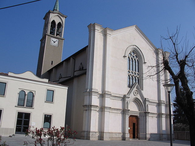
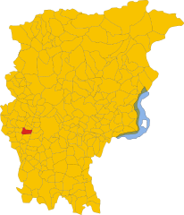
Мапелло (Mapello, Mapello)
.svg)
- коммуна Италии
 Hiking in Мапелло
Mapello, located in the Lombardy region of Italy, is a charming area that offers various opportunities for hiking enthusiasts. The landscape surrounding Mapello features rolling hills, woodlands, and scenic views of the surrounding mountains and countryside, making it a great destination for outdoor activities.
Hiking Trails and Areas
-
Parco Regionale della Val Cavallina: Close to Mapello, this regional park offers several hiking trails that take you through picturesque landscapes, including lakes, forests, and rural areas. The Val Cavallina is known for its beautiful natural scenery.
-
Sentieristica Locale (Local Hiking Trails): There are several marked local trails in the area that provide a range of difficulty levels, catering to both beginners and experienced hikers. You can explore the rich flora and fauna as well as enjoy panoramic views of the surrounding region.
-
Monte Canto: Located near Mapello, Monte Canto offers a more challenging hike with rewarding views at the summit. The trails here are well marked and range in difficulty, ensuring an enjoyable experience for all levels of hikers.
Tips for Hiking in Mapello
-
Best Time to Hike: The ideal time for hiking in this region is during the spring and fall when temperatures are milder and the scenery is particularly beautiful.
-
Preparation and Gear: Ensure you have proper hiking boots, water, snacks, and a map or GPS device. It's also wise to check the weather forecast before heading out.
-
Wildlife and Nature: Keep an eye out for local wildlife, including various bird species and native plants. Respect the environment by sticking to marked paths.
-
Local Culture: Take some time to explore Mapello itself after your hike. The area has a rich history, charming architecture, and local eateries where you can enjoy authentic Italian cuisine.
Overall, hiking in Mapello can be a rewarding and picturesque experience, combining the joy of nature with the beauty of Italian culture.
- Страна:

- Почтовый код: 24030
- Телефонный код: 035
- Код автомобильного номера: BG
- Координаты: 45° 42' 32" N, 9° 32' 52" E


- GPS треки (wikiloc): [Ссылка]
- Высота над уровнем моря: 255 м m
- Площадь: 8.66 кв.км
- Население: 6840
- Веб сайт: http://www.comune.mapello.bg.it
- Википедия русская: wiki(ru)
- Википедия английская: wiki(en)
- Википедия национальная: wiki(it)
- Хранилище Wikidata: Wikidata: Q101226
- Галерея изображений в википедии: [Ссылка]
- Катеория в википедии: [Ссылка]
- код Freebase: [/m/0gjbyp]
- код GeoNames: Альт: [6541590]
- код VIAF: Альт: [152152750]
- ID отношения в OpenStreetMap: [45782]
- место в MusicBrainz: [8166d1d5-2d88-4295-99cc-01519581230e]
- код TGN: [5002523]
- UN/LOCODE: [ITMPL]
- код ISTAT: 016132
- кадастровый код Италии: E901
Граничит с регионами:


Палаццаго
- коммуна Италии
Hiking in Палаццаго
Palazzago, located in the Lombardy region of Italy, offers a picturesque setting for hiking enthusiasts. Nestled in the foothills of the Bergamasque Alps, this area features a mix of natural beauty, historical sites, and charming villages, making it an attractive destination for outdoor activities....
- Страна:
- Почтовый код: 24030
- Телефонный код: 035
- Код автомобильного номера: BG
- Координаты: 45° 45' 7" N, 9° 32' 7" E
- GPS треки (wikiloc): [Ссылка]
- Высота над уровнем моря: 397 м m
- Площадь: 13.98 кв.км
- Население: 4497
- Веб сайт: [Ссылка]


Понте-Сан-Пьетро
- коммуна Италии
Hiking in Понте-Сан-Пьетро
Ponte San Pietro, located in the province of Bergamo in Lombardy, Italy, is a picturesque area that serves as a gateway to various hiking opportunities in the surrounding region. Here are some aspects to consider if you're planning to hike in and around Ponte San Pietro:...
- Страна:
- Почтовый код: 24036
- Телефонный код: 035
- Код автомобильного номера: BG
- Координаты: 45° 42' 21" N, 9° 35' 26" E
- GPS треки (wikiloc): [Ссылка]
- Высота над уровнем моря: 224 м m
- Площадь: 4.59 кв.км
- Население: 11502
- Веб сайт: [Ссылка]


Презеццо
- коммуна Италии
Hiking in Презеццо
Presezzo is a charming municipality located in the province of Bergamo, in the Lombardy region of Italy. While it may not be one of the most famous hiking destinations, it offers several opportunities for nature lovers and outdoor enthusiasts to explore its scenic landscapes, particularly around the nearby hills and forests....
- Страна:
- Почтовый код: 24030
- Телефонный код: 035
- Код автомобильного номера: BG
- Координаты: 45° 41' 29" N, 9° 33' 59" E
- GPS треки (wikiloc): [Ссылка]
- Высота над уровнем моря: 236 м m
- Площадь: 2.28 кв.км
- Население: 4905
- Веб сайт: [Ссылка]


Сотто-иль-Монте-Джованни-XXIII
- коммуна Италии
Hiking in Сотто-иль-Монте-Джованни-XXIII
Sotto il Monte Giovanni XXIII is a picturesque area located in the Lombardy region of Italy, known for its natural beauty, rolling hills, and historical significance, particularly as the birthplace of Pope John XXIII. Hiking in this area offers a blend of serene landscapes, cultural landmarks, and opportunities for various outdoor activities....
- Страна:
- Почтовый код: 24039
- Телефонный код: 035
- Код автомобильного номера: BG
- Координаты: 45° 42' 26" N, 9° 29' 57" E
- GPS треки (wikiloc): [Ссылка]
- Высота над уровнем моря: 305 м m
- Площадь: 5.02 кв.км
- Население: 3864
- Веб сайт: [Ссылка]


Терно-д'Изола
- коммуна Италии
Hiking in Терно-д'Изола
Terno d'Isola is a charming town located in the province of Bergamo, Lombardy, Italy. While it’s not typically recognized as a primary hiking destination, the surrounding region offers some lovely trails and opportunities for outdoor activities. Here are some insights about hiking in and around Terno d'Isola:...
- Страна:
- Почтовый код: 24030
- Телефонный код: 035
- Код автомобильного номера: BG
- Координаты: 45° 41' 0" N, 9° 32' 0" E
- GPS треки (wikiloc): [Ссылка]
- Высота над уровнем моря: 299 м m
- Площадь: 4.13 кв.км
- Население: 8106
- Веб сайт: [Ссылка]

Амбивере
- коммуна Италии
Hiking in Амбивере
Ambivere, located in the Indian state of Karnataka, is a hidden gem for hiking enthusiasts. Nestled in the picturesque landscapes of the Western Ghats, this area offers a range of outdoor activities amid lush greenery, hills, and serene natural beauty. Here’s what you might want to know about hiking in Ambivere:...
- Страна:
- Почтовый код: 24030
- Телефонный код: 035
- Код автомобильного номера: BG
- Координаты: 45° 43' 4" N, 9° 32' 55" E
- GPS треки (wikiloc): [Ссылка]
- Высота над уровнем моря: 261 м m
- Площадь: 3.28 кв.км
- Население: 2348
- Веб сайт: [Ссылка]


Барцана
- коммуна Италии
Hiking in Барцана
Barzana, located in the province of Bergamo in northern Italy, is surrounded by beautiful landscapes and offers various hiking opportunities. The area is characterized by rolling hills, scenic views, and cultural heritage, making it an excellent spot for both novice and experienced hikers....
- Страна:
- Почтовый код: 24030
- Телефонный код: 035
- Код автомобильного номера: BG
- Координаты: 45° 44' 2" N, 9° 34' 3" E
- GPS треки (wikiloc): [Ссылка]
- Высота над уровнем моря: 300 м m
- Площадь: 2.07 кв.км
- Население: 1980
- Веб сайт: [Ссылка]

Бонате-Сопра
- коммуна Италии
Hiking in Бонате-Сопра
Bonate Sopra, located in the Lombardy region of Italy, offers a variety of picturesque landscapes and opportunities for hiking enthusiasts. Nestled close to the hills of Bergamo, this area is ideal for those who enjoy nature and scenic views....
- Страна:
- Почтовый код: 24040
- Телефонный код: 035
- Код автомобильного номера: BG
- Координаты: 45° 40' 55" N, 9° 33' 31" E
- GPS треки (wikiloc): [Ссылка]
- Высота над уровнем моря: 320 м m
- Площадь: 6.15 кв.км
- Население: 10020
- Веб сайт: [Ссылка]


Брембате-ди-Сопра
- коммуна Италии
Hiking in Брембате-ди-Сопра
Brembate di Sopra, located in the Lombardy region of Italy, is a charming town that offers access to beautiful hiking trails and the surrounding natural landscape. Here are some key points about hiking in and around Brembate di Sopra:...
- Страна:
- Почтовый код: 24030
- Телефонный код: 035
- Код автомобильного номера: BG
- Координаты: 45° 43' 4" N, 9° 34' 50" E
- GPS треки (wikiloc): [Ссылка]
- Высота над уровнем моря: 267 м m
- Площадь: 4.14 кв.км
- Население: 7868
- Веб сайт: [Ссылка]