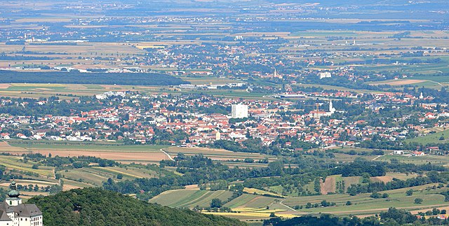
Маттерсбург (Mattersburg District, Bezirk Mattersburg)

 Hiking in Маттерсбург
Mattersburg District, located in the eastern part of Austria, is known for its diverse landscapes, charming villages, and picturesque countryside, making it a great destination for hiking enthusiasts. Here are some highlights and tips for hiking in the area:
Trails and Areas:
-
Naturpark Geschriebenstein: This nature park is a popular destination for hikers, offering a range of trails that cater to all skill levels. The park is home to the highest peak in the region, the Geschriebenstein, which provides stunning panoramic views.
-
Parks and Reserves: Beyond Naturpark Geschriebenstein, the Mattersburg District features various smaller parks and reserves where you can enjoy hiking amid rich flora and fauna.
-
Wine Trails: The region is partially in the Burgenland wine region, so some trails run through vineyards. These trails often offer not just beautiful scenery but also the opportunity to taste local wines.
-
Cultural Paths: In addition to nature, there are trails that connect historical and cultural sites, giving hikers a chance to learn about the local heritage while enjoying the outdoors.
What to Expect:
- Scenic Views: The hiking routes offer beautiful views of the surrounding hills, forests, and vineyards, particularly in the changing seasons.
- Wildlife: Keep an eye out for local wildlife. The region is home to various bird species and other animals, especially in protected areas.
- Local Amenities: Many trails are accessible from local villages, where you can find places to eat and rest.
Tips for Hiking in Mattersburg:
- Preparation: Always check trail maps and trail conditions before heading out. Some paths might be more challenging than they appear.
- Weather Considerations: Be aware of the weather forecasts, as conditions can change quickly in mountainous areas.
- Respect Nature: Follow Leave No Trace principles to keep the hiking areas pristine.
- Safety: Let someone know your hiking plan and estimated return time, especially if you're hiking alone or in more remote areas.
- Local Guides: If you're unfamiliar with the area or want to learn more about its history and ecology, consider hiring a local guide.
Conclusion:
Hiking in the Mattersburg District can be a rewarding experience filled with natural beauty and cultural richness. Whether you're a novice or a seasoned hiker, there are paths suitable for everyone. Always be prepared, respect nature, and enjoy your hike!
- Страна:

- Код автомобильного номера: MA
- Координаты: 47° 44' 46" N, 16° 25' 1" E


- GPS треки (wikiloc): [Ссылка]
- Высота над уровнем моря: 243 м m
- Площадь: 237.84 кв.км
- Население: 39599
- Википедия русская: wiki(ru)
- Википедия английская: wiki(en)
- Википедия национальная: wiki(de)
- Хранилище Wikidata: Wikidata: Q748570
- Катеория в википедии: [Ссылка]
- код Freebase: [/m/06vtm7]
- код GeoNames: Альт: [2771816]
- код VIAF: Альт: [132677665]
- код GND: Альт: [4037996-6]
- идентификатор местоположения ArchINFORM: [14662]
- код LCNAF: Альт: [n93096479]
Включает регионы:

Цемендорф-Штёттера
Hiking in Цемендорф-Штёттера
Zemendorf-Stöttera is a small village located in Austria, near the border with Hungary. While it may not be as well-known as some of the larger hiking destinations in the country, it offers opportunities for those looking to explore the scenic landscapes of the region....
- Страна:
- Почтовый код: 7023
- Телефонный код: 02626
- Код автомобильного номера: MA
- Координаты: 47° 45' 56" N, 16° 27' 17" E
- GPS треки (wikiloc): [Ссылка]
- Высота над уровнем моря: 198 м m
- Площадь: 12.83 кв.км
- Население: 1268
- Веб сайт: [Ссылка]
Маттерсбург
Hiking in Маттерсбург
Mattersburg, located in Burgenland, Austria, offers a range of hiking opportunities, surrounded by beautiful landscapes, vineyards, and rich natural scenery. Here are some highlights for hikers in and around Mattersburg:...
- Страна:
- Почтовый код: 7210
- Телефонный код: 02626
- Код автомобильного номера: MA
- Координаты: 47° 44' 17" N, 16° 23' 49" E
- GPS треки (wikiloc): [Ссылка]
- Высота над уровнем моря: 256 м m
- Площадь: 28.2 кв.км
- Население: 7349
- Веб сайт: [Ссылка]

Хирм
Hiking in Хирм
Hirm is a small village in Hungary known for its picturesque landscape and proximity to various hiking trails that allow you to explore the surrounding natural beauty. Hiking in this area typically involves a combination of nature walks, forest trails, and scenic viewpoints. Here are some points to consider if you're planning a hiking trip in Hirm:...
- Страна:
- Почтовый код: 7024
- Телефонный код: 02687
- Код автомобильного номера: MA
- Координаты: 47° 47' 16" N, 16° 27' 20" E
- GPS треки (wikiloc): [Ссылка]
- Высота над уровнем моря: 183 м m
- Площадь: 3.12 кв.км
- Население: 1009
- Веб сайт: [Ссылка]
Пёттельсдорф
Hiking in Пёттельсдорф
Pöttelsdorf is a charming village located in Austria, known for its picturesque landscapes and serene countryside. While it's not typically crowded with tourists, it offers some beautiful hiking opportunities for nature enthusiasts. Here are some things to consider if you plan on hiking in the area:...
- Страна:
- Почтовый код: 7023
- Телефонный код: 02626
- Код автомобильного номера: MA
- Координаты: 47° 45' 9" N, 16° 26' 12" E
- GPS треки (wikiloc): [Ссылка]
- Высота над уровнем моря: 205 м m
- Площадь: 7.86 кв.км
- Население: 735
- Веб сайт: [Ссылка]

Драсбург
Hiking in Драсбург
Draßburg, located in Austria, is known for its scenic landscapes, making it a great destination for hiking enthusiasts. Nestled near the foothills of the Alps, this area offers various trails that cater to different skill levels, from beginner to advanced hikers....
- Страна:
- Почтовый код: 7021
- Телефонный код: 02686
- Код автомобильного номера: MA
- Координаты: 47° 44' 46" N, 16° 29' 17" E
- GPS треки (wikiloc): [Ссылка]
- Высота над уровнем моря: 223 м m
- Площадь: 9.67 кв.км
- Население: 1199
- Веб сайт: [Ссылка]
Антау
Hiking in Антау
It seems there may be a mix-up with the name "Antau," as it does not correspond to any well-known hiking destination or region in my training data. However, if you meant a specific area or region that sounds similar, please provide more details....
- Страна:
- Почтовый код: 7042
- Телефонный код: 02687
- Код автомобильного номера: MA
- Координаты: 47° 46' 25" N, 16° 28' 36" E
- GPS треки (wikiloc): [Ссылка]
- Высота над уровнем моря: 189 м m
- Площадь: 8.75 кв.км
- Население: 758
- Веб сайт: [Ссылка]


Лойперсбах-им-Бургенланд
- община в Австрии
Hiking in Лойперсбах-им-Бургенланд
Loipersbach im Burgenland is a charming area located in Austria, known for its beautiful landscapes and outdoor activities, making it a great destination for hiking enthusiasts. Hiking in this region offers a unique combination of scenic views, diverse terrain, and the opportunity to experience the rich cultural and natural heritage of Burgenland....
- Страна:
- Почтовый код: 7020
- Телефонный код: 02686
- Код автомобильного номера: MA
- Координаты: 47° 41' 45" N, 16° 28' 20" E
- GPS треки (wikiloc): [Ссылка]
- Высота над уровнем моря: 292 м m
- Площадь: 8.54 кв.км
- Население: 1229
- Веб сайт: [Ссылка]
Зиглес
Hiking in Зиглес
Sigleß is a charming village in Hungary, located near the popular region of Lake Balaton. While not as widely known as some other hiking destinations, it offers a peaceful environment and a chance to explore beautiful natural landscapes. Here are some hiking opportunities and points of interest in and around Sigleß:...
- Страна:
- Почтовый код: 7032
- Телефонный код: 02626
- Код автомобильного номера: MA
- Координаты: 47° 46' 39" N, 16° 23' 44" E
- GPS треки (wikiloc): [Ссылка]
- Высота над уровнем моря: 207 м m
- Площадь: 10.2 кв.км
- Население: 1183
- Веб сайт: [Ссылка]

Зигграбен
- политическая община в Австрии
Hiking in Зигграбен
Sieggraben, located in Austria, offers beautiful landscapes and a variety of hiking opportunities. This area is known for its lush greenery, gentle hills, and scenic views typical of the Lower Austria region....
- Страна:
- Почтовый код: 7223
- Телефонный код: 02621
- Код автомобильного номера: MA
- Координаты: 47° 38' 59" N, 16° 22' 50" E
- GPS треки (wikiloc): [Ссылка]
- Высота над уровнем моря: 450 м m
- Площадь: 17.7 кв.км
- Население: 1248
- Веб сайт: [Ссылка]

Нойдёрфль
Hiking in Нойдёрфль
Neudörfl is a charming village located in the Burgenland region of Austria. Surrounded by natural beauty and a tranquil countryside, it offers various opportunities for hiking enthusiasts. Here are some key points to consider when hiking in and around Neudörfl:...
- Страна:
- Почтовый код: 7201
- Телефонный код: 02622
- Код автомобильного номера: MA
- Координаты: 47° 47' 52" N, 16° 17' 48" E
- GPS треки (wikiloc): [Ссылка]
- Высота над уровнем моря: 273 м m
- Площадь: 9.01 кв.км
- Население: 4564
- Веб сайт: [Ссылка]

Бад-Зауэрбрунн
- политическая община в Австрии
Hiking in Бад-Зауэрбрунн
Bad Sauerbrunn, located in the Burgenland region of Austria, is known for its natural beauty and therapeutic mineral springs. The area offers a variety of hiking opportunities that cater to different skill levels and preferences. Here are some highlights regarding hiking in Bad Sauerbrunn:...
- Страна:
- Почтовый код: 7202
- Телефонный код: 0 26 25
- Код автомобильного номера: MA
- Координаты: 47° 46' 0" N, 16° 20' 0" E
- GPS треки (wikiloc): [Ссылка]
- Высота над уровнем моря: 280 м m
- Площадь: 2.35 кв.км
- Население: 2219
- Веб сайт: [Ссылка]

Баумгартен
Hiking in Баумгартен
Baumgarten, located in Burgenland, Austria, is a picturesque area known for its beautiful landscapes and serene hiking trails. While it may not be as widely recognized as some of Austria's more famous hiking destinations, it offers a unique experience for outdoor enthusiasts....
- Страна:
- Почтовый код: 7021
- Телефонный код: 02686
- Код автомобильного номера: MA
- Координаты: 47° 44' 20" N, 16° 30' 8" E
- GPS треки (wikiloc): [Ссылка]
- Высота над уровнем моря: 255 м m
- Площадь: 7 кв.км
- Население: 894
- Веб сайт: [Ссылка]
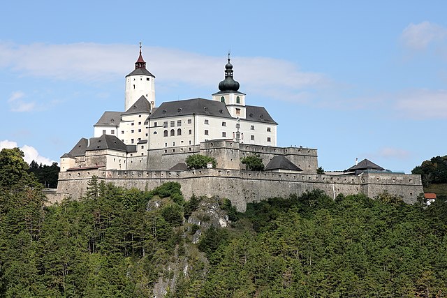

Форхтенштайн
Hiking in Форхтенштайн
Forchtenstein, located in Austria's Burgenland region, is known for its scenic landscapes, charming villages, and rich history. The area surrounding Forchtenstein offers a variety of hiking opportunities that cater to different skill levels, making it ideal for both seasoned hikers and beginners....
- Страна:
- Почтовый код: 7212
- Телефонный код: 02626
- Код автомобильного номера: MA
- Координаты: 47° 42' 41" N, 16° 20' 29" E
- GPS треки (wikiloc): [Ссылка]
- Высота над уровнем моря: 343 м m
- Площадь: 16.59 кв.км
- Население: 2796
- Веб сайт: [Ссылка]

Визен
- община в Австрии, Бургенланд, Маттерсбург
Hiking in Визен
Wiesen, Austria, is a charming village located in the scenic region of Styria, nestled in the Austrian Alps. This area is known for its stunning natural beauty, rolling hills, dense forests, and picturesque landscapes, making it a great destination for hiking enthusiasts. Here are some key points to consider if you're planning a hiking trip in Wiesen:...
- Страна:
- Почтовый код: 7203
- Телефонный код: 02626
- Код автомобильного номера: MA
- Координаты: 47° 44' 22" N, 16° 20' 24" E
- GPS треки (wikiloc): [Ссылка]
- Высота над уровнем моря: 309 м m
- Площадь: 18.91 кв.км
- Население: 2691
- Веб сайт: [Ссылка]


Пётчинг
Hiking in Пётчинг
Pöttsching, located in Austria's Lower Austria region, is surrounded by beautiful landscapes that are suitable for hiking enthusiasts. The area features gentle hills, woodlands, and scenic views, making it an excellent destination for outdoor activities....
- Страна:
- Почтовый код: 7033
- Телефонный код: 0664
- Код автомобильного номера: MA
- Координаты: 47° 48' 24" N, 16° 22' 10" E
- GPS треки (wikiloc): [Ссылка]
- Высота над уровнем моря: 218 м m
- Площадь: 24.6 кв.км
- Население: 2950
- Веб сайт: [Ссылка]
Кренсдорф
Hiking in Кренсдорф
Krensdorf is a quaint village located in Austria, known for its beautiful landscapes and access to outdoor activities, including hiking. While the village itself may not have extensive hiking trails, it is surrounded by stunning natural areas that offer great opportunities for exploration....
- Страна:
- Почтовый код: 7031
- Телефонный код: 02626
- Код автомобильного номера: MA
- Координаты: 47° 47' 10" N, 16° 24' 51" E
- GPS треки (wikiloc): [Ссылка]
- Высота над уровнем моря: 193 м m
- Площадь: 7.79 кв.км
- Население: 642
- Веб сайт: [Ссылка]

Шаттендорф
Hiking in Шаттендорф
Schattendorf is a small municipality in Austria, located in the state of Burgenland. While it isn’t a well-known hiking destination, it has the charm of the Austrian countryside and offers opportunities for hiking in nearby areas....
- Страна:
- Почтовый код: 7022
- Телефонный код: 0664
- Код автомобильного номера: MA
- Координаты: 47° 42' 39" N, 16° 30' 38" E
- GPS треки (wikiloc): [Ссылка]
- Высота над уровнем моря: 256 м m
- Площадь: 12.1 кв.км
- Население: 2379
- Веб сайт: [Ссылка]

Рорбах-бай-Маттерсбург
- политическая община в Австрии
Hiking in Рорбах-бай-Маттерсбург
Rohrbach bei Mattersburg, located in the Burgenland region of Austria, is an appealing destination for hiking enthusiasts. The region is characterized by its picturesque landscapes, rolling hills, vineyards, and forests, making it a great spot for a variety of hiking activities....
- Страна:
- Почтовый код: 7222
- Телефонный код: 02626
- Код автомобильного номера: MA
- Координаты: 47° 42' 35" N, 16° 25' 38" E
- GPS треки (wikiloc): [Ссылка]
- Высота над уровнем моря: 266 м m
- Площадь: 15.23 кв.км
- Население: 2707
- Веб сайт: [Ссылка]
Марц
Hiking in Марц
Hiking in Marz, Austria, offers a delightful experience especially for those who enjoy picturesque landscapes, rich nature, and the charm of small Austrian towns. Marz is located in the Burgenland region, known for its scenic vineyards, rolling hills, and proximity to the Örség National Park....
- Страна:
- Почтовый код: 7221
- Телефонный код: 0 2626
- Код автомобильного номера: MA
- Координаты: 47° 43' 0" N, 16° 24' 58" E
- GPS треки (wikiloc): [Ссылка]
- Высота над уровнем моря: 252 м m
- Площадь: 17.4 кв.км
- Население: 2073
- Веб сайт: [Ссылка]