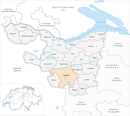
Матцинген (Matzingen, Matzingen)

 Hiking in Матцинген
Matzingen, located in the canton of Thurgau in Switzerland, offers some lovely hiking opportunities, often accompanied by beautiful landscapes, rolling hills, and picturesque countryside. Here’s an overview to help you with your hiking plans:
Hiking Trails
-
Regional Trails: The region has several marked hiking trails that cater to different skill levels. Trail markers are usually well maintained, and hiking maps are available at local tourist information centers.
-
Nature Trails: Some trails focus on nature observation, highlighting local flora and fauna. These paths are generally gentle and suitable for families.
-
Hiking Routes Around the Thur River: Nearby, the Thur River provides scenic routes with picturesque views and opportunities for spot rest areas along the water.
Difficulty Levels
- Easy: Family-friendly trails are ideal for beginners and those with young children.
- Moderate: Suitable for those who have some hiking experience, these paths may include gentle inclines.
- Difficult: More challenging routes are available for seasoned hikers, with steeper climbs and rugged terrain.
Best Time to Hike
- Spring: Flowers bloom, and the weather is mild.
- Summer: Warm temperatures are great for hiking, but be prepared for the occasional rain.
- Fall: The autumn foliage provides stunning scenery; however, trails can sometimes be muddy.
- Winter: Some trails may be accessible for winter hiking or snowshoeing, but always check for conditions and safety.
Preparations
- Gear: Wear sturdy hiking boots, bring plenty of water, food, and a basic first-aid kit. A compass or GPS device is handy, too.
- Clothing: Dress in layers to adjust to changing weather conditions.
- Navigation: Consider downloading offline maps or having a physical map available, as cell service may be limited in some areas.
Local Recommendations
- Visiting Grapevines: The region is known for its vineyards; consider incorporating a stop at a winery for tasting local wines.
- Historic Sites: Check for trails that may lead to historical landmarks in the area, enhancing your hiking experience.
Safety Tips
- Always inform someone about your hiking plans and estimated return.
- Check the weather forecast before heading out.
- Be aware of your surroundings and any potential wildlife.
Conclusion
Matzingen provides a charming blend of nature, culture, and history for hiking enthusiasts. Whether you're looking for a relaxed stroll or a more challenging hike, there’s something for everyone. Enjoy your adventure!
- Страна:

- Почтовый код: 9548
- Телефонный код: 052
- Код автомобильного номера: TG
- Координаты: 47° 31' 36" N, 8° 55' 46" E


- GPS треки (wikiloc): [Ссылка]
- Высота над уровнем моря: 480 м m
- Площадь: 7.7 кв.км
- Население: 2857
- Веб сайт: http://www.matzingen.ch
- Википедия русская: wiki(ru)
- Википедия английская: wiki(en)
- Википедия национальная: wiki(de)
- Хранилище Wikidata: Wikidata: Q64994
- Катеория в википедии: [Ссылка]
- код Freebase: [/m/0g3sw2]
- код GeoNames: Альт: [7286461]
- код VIAF: Альт: [239640820]
- ID отношения в OpenStreetMap: [1684542]
- идентификатор HDS: [1908]
- код швейцарского муниципалитета: [4591]
Граничит с регионами:


Тундорф
Hiking in Тундорф
Thundorf is a charming village located in the Thurgau region of Switzerland, surrounded by beautiful landscapes that are perfect for hiking enthusiasts. While it might not be as well-known as some other Swiss hiking destinations, it offers a variety of trails that take you through serene nature, vineyards, and picturesque countryside....
- Страна:
- Почтовый код: 8512
- Телефонный код: 052
- Код автомобильного номера: TG
- Координаты: 47° 32' 50" N, 8° 57' 52" E
- GPS треки (wikiloc): [Ссылка]
- Высота над уровнем моря: 546 м m
- Площадь: 15.6 кв.км
- Население: 1452
- Веб сайт: [Ссылка]


Штетфурт
Hiking in Штетфурт
Stettfurt, located in the picturesque region of Thurgau in Switzerland, offers a wonderful setting for hiking enthusiasts. The area features a variety of trails that cater to different skill levels, from easy walks suitable for families to more challenging routes for experienced hikers....
- Страна:
- Почтовый код: 9507
- Телефонный код: 052
- Код автомобильного номера: TG
- Координаты: 47° 31' 34" N, 8° 57' 20" E
- GPS треки (wikiloc): [Ссылка]
- Высота над уровнем моря: 488 м m
- Площадь: 6.4 кв.км
- Население: 1210
- Веб сайт: [Ссылка]

Фрауэнфельд
Hiking in Фрауэнфельд
Frauenfeld, the capital of the Canton of Thurgau in Switzerland, offers a range of beautiful hiking opportunities that cater to various skill levels, from leisurely walks to challenging hikes. Here are some key points to consider when hiking in and around Frauenfeld:...
- Страна:
- Почтовый код: 8500
- Телефонный код: 052
- Код автомобильного номера: TG
- Координаты: 47° 33' 21" N, 8° 53' 47" E
- GPS треки (wikiloc): [Ссылка]
- Высота над уровнем моря: 417 м m
- Площадь: 27.4 кв.км
- Население: 25442
- Веб сайт: [Ссылка]


Венги
Hiking in Венги
Wängi, located in the canton of Thurgau in Switzerland, is a lovely area for hiking enthusiasts. The region is characterized by its picturesque landscapes, including rolling hills, forests, and agricultural fields, making it a peaceful retreat for outdoor activities....
- Страна:
- Почтовый код: 9545
- Телефонный код: 052
- Код автомобильного номера: TG
- Координаты: 47° 29' 36" N, 8° 57' 27" E
- GPS треки (wikiloc): [Ссылка]
- Высота над уровнем моря: 500 м m
- Площадь: 16.4 кв.км
- Население: 4662
- Веб сайт: [Ссылка]


Адорф
Hiking in Адорф
Aadorf, located in the canton of Thurgau in Switzerland, offers some beautiful hiking opportunities that cater to various skill levels. The region is characterized by its picturesque landscapes, rolling hills, and lush greenery. Here are some key aspects of hiking in Aadorf:...
- Страна:
- Почтовый код: 8355
- Телефонный код: 052
- Код автомобильного номера: TG
- Координаты: 47° 29' 35" N, 8° 54' 37" E
- GPS треки (wikiloc): [Ссылка]
- Высота над уровнем моря: 534 м m
- Площадь: 20.0 кв.км
- Население: 8885
- Веб сайт: [Ссылка]