Мельмайзель (Mehlmeisel, Mehlmeisel)

 Hiking in Мельмайзель
Mehlmeisel is a charming village located in the Fichtelgebirge region of Bavaria, Germany, known for its stunning natural landscapes and outdoor recreational opportunities, particularly hiking. Here are some highlights for hiking in and around Mehlmeisel:
Trail Options:
-
Local Hiking Trails: Mehlmeisel has several well-marked trails that cater to various skill levels. The trails often lead through dense forests, picturesque meadows, and along beautiful mountain ridges, offering stunning views of the surrounding countryside.
-
Fichtelgebirge Nature Park: The nearby Fichtelgebirge Nature Park features a vast network of hiking trails. You can explore the unique granite rock formations, the highest peaks in the region, and scenic viewpoints. Don't miss the summit of Schneeberg, the highest mountain in the Fichtelgebirge.
-
Circular Hikes: Look for circular hiking routes that allow you to enjoy a variety of landscapes without retracing your steps. Many trails can be combined for longer hikes or shorter loops based on your preference.
Scenic Highlights:
-
Epprechtstein Castle: Hike to this historic castle for fantastic panoramic views of the Fichtelgebirge region. The hike is moderate in difficulty, but the views are worth it.
-
Jonswiesen: A beautiful area for picnicking and enjoying the lush greenery. The surrounding trails offer quiet solitude and a chance to connect with nature.
-
Granite Formations: The region is known for its unique rock formations, which can be fascinating to explore while hiking.
Tips for Hiking in Mehlmeisel:
-
Weather Preparation: Be sure to check the weather forecast before heading out, as conditions can change rapidly in the mountains.
-
Trail Maps: Carry a trail map or download a hiking app that provides GPS navigation, as some trails can be less marked.
-
Footwear and Gear: Wear sturdy hiking boots to handle varying terrain, and pack sufficient water and snacks for your adventure.
-
Respect Nature: Stay on marked trails, follow local guidelines, and pack out any trash to help preserve the beautiful landscapes.
Conclusion:
Mehlmeisel and the surrounding Fichtelgebirge region offer fantastic hiking opportunities with diverse trails, rich natural beauty, and cultural landmarks. Whether you're looking for a leisurely stroll through the forest or a challenging mountain hike, you'll find a suitable path to enjoy the great outdoors in this picturesque Bavarian village.
- Страна:

- Почтовый код: 95694
- Телефонный код: 09272
- Код автомобильного номера: BT
- Координаты: 49° 58' 34" N, 11° 51' 18" E


- GPS треки (wikiloc): [Ссылка]
- Высота над уровнем моря: 621 м m
- Площадь: 13.23 кв.км
- Население: 1321
- Веб сайт: http://www.mehlmeisel.de
- Википедия русская: wiki(ru)
- Википедия английская: wiki(en)
- Википедия национальная: wiki(de)
- Хранилище Wikidata: Wikidata: Q503844
- Катеория в википедии: [Ссылка]
- код Freebase: [/m/02q0zb4]
- код GeoNames: Альт: [2872417]
- код VIAF: Альт: [245683799]
- ID отношения в OpenStreetMap: [1070972]
- код GND: Альт: [4115078-8]
- WOEID: [674510]
- Bavarikon ID: [ODB_A00001998]
- идентификатор муниципалитетов в Германии: 09472164
Граничит с регионами:
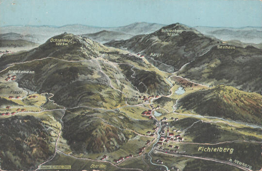

Фихтельберг
Hiking in Фихтельберг
Fichtelberg, located in Bavaria, is a beautiful destination for hiking enthusiasts. It is situated in the Fichtel Mountains, an area known for its stunning landscapes, dense forests, and unique rock formations. Here are some highlights and tips for hiking in the Fichtelberg region:...
- Страна:
- Почтовый код: 95686
- Телефонный код: 09272
- Код автомобильного номера: BT
- Координаты: 49° 59' 58" N, 11° 51' 5" E
- GPS треки (wikiloc): [Ссылка]
- Высота над уровнем моря: 685 м m
- Площадь: 5.17 кв.км
- Население: 2192
- Веб сайт: [Ссылка]