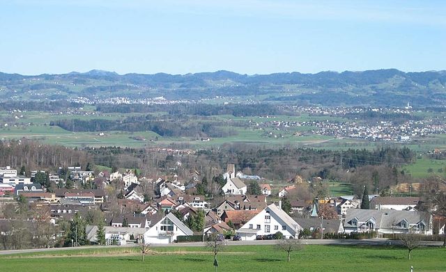
Майлен (Meilen, Meilen)

- город в Швейцарии
 Hiking in Майлен
Meilen, located on the shores of Lake Zurich in Switzerland, is a picturesque village that offers a range of hiking trails suitable for different skill levels. Here are some highlights and tips for hiking in the Meilen area:
Popular Hiking Trails:
-
Uetikon to Meilen Trail:
- Difficulty: Easy to Moderate
- Distance: Approximately 5 km
- This scenic trail follows the lakeshore and provides beautiful views of Lake Zurich and the surrounding mountains. It's ideal for families and those looking for a leisurely hike.
-
Meilen to the Zürichberg:
- Difficulty: Moderate
- Distance: About 10 km
- This trail takes you from Meilen up into the hills, offering a more challenging hike with rewarding views over Lake Zurich.
-
Pfannenstiel:
- Difficulty: Moderate
- This area has various well-marked trails leading through forests and meadows. The Pfannenstiel is a fantastic spot for panoramic views and photography.
Scenic Highlights:
- Expect to pass through charming vineyards, serene forests, and open meadows brimming with wildflowers during spring and summer.
- The views across Lake Zurich, with the Alps in the background, are breathtaking and make for excellent photo opportunities.
Seasonal Considerations:
- Spring and Summer: Ideal for hiking with longer daylight hours and blossoming nature.
- Autumn: Beautiful fall foliage can make hikes especially scenic.
- Winter: Some trails may be accessible for winter hiking, but ensure that you check conditions and trail accessibility.
General Tips:
- Dress in layers: Weather in the mountains can change quickly, so it’s best to be prepared.
- Stay Hydrated: Bring enough water, especially during warmer months.
- Respect Nature: Follow local guidelines to maintain the natural beauty of the area.
- Check local resources: Before setting out, consult local hiking maps or guides for the latest trail conditions and safety information.
Transportation:
- Meilen is well-connected by public transportation, making it easy to reach popular hiking spots starting from the village. Consider taking a train or bus to start your hike and enjoy the scenery along the way!
By exploring the trails around Meilen, you're sure to experience the natural beauty and charm of this lovely region in Switzerland. Happy hiking!
- Страна:

- Почтовый код: 8706
- Телефонный код: 01
- Код автомобильного номера: ZH
- Координаты: 47° 16' 13" N, 8° 38' 28" E


- GPS треки (wikiloc): [Ссылка]
- Высота над уровнем моря: 420 м m
- Площадь: 11.93 кв.км
- Население: 13999
- Веб сайт: http://www.meilen.ch
- Википедия русская: wiki(ru)
- Википедия английская: wiki(en)
- Википедия национальная: wiki(de)
- Хранилище Wikidata: Wikidata: Q68261
- Катеория в википедии: [Ссылка]
- код Freebase: [/m/01tnjs]
- код GeoNames: Альт: [7286472]
- код BNF: [11980560r]
- код VIAF: Альт: [151416447]
- ID отношения в OpenStreetMap: [1682165]
- код GND: Альт: [4115081-8]
- идентификатор местоположения ArchINFORM: [6511]
- идентификатор HDS: [111]
- код швейцарского муниципалитета: [0156]
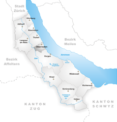
Граничит с регионами:

Эгг (Цюрих)
Hiking in Эгг (Цюрих)
Egg, located in the Canton of Zurich in Switzerland, is a charming village nestled in the lush landscapes of the Zürcher Oberland. It offers a variety of hiking options suitable for all skill levels. Here are some highlights of hiking in and around Egg:...
- Страна:
- Почтовый код: 8132
- Телефонный код: 01; 043; 044
- Код автомобильного номера: ZH
- Координаты: 47° 18' 7" N, 8° 41' 26" E
- GPS треки (wikiloc): [Ссылка]
- Высота над уровнем моря: 545 м m
- Площадь: 14.48 кв.км
- Население: 8452
- Веб сайт: [Ссылка]
Оберриден
Hiking in Оберриден
Oberrieden, a picturesque municipality in the canton of Zurich, Switzerland, offers a wonderful backdrop for hiking enthusiasts. The area is characterized by its scenic landscapes, which include rolling hills, lush forests, and stunning views of Lake Zurich and the Swiss Alps....
- Страна:
- Почтовый код: 8942
- Телефонный код: 043; 044
- Код автомобильного номера: ZH
- Координаты: 47° 16' 40" N, 8° 34' 41" E
- GPS треки (wikiloc): [Ссылка]
- Высота над уровнем моря: 460 м m
- Площадь: 2.76 кв.км
- Население: 5090
- Веб сайт: [Ссылка]


Итикон-ам-Зе
- город в Швейцарии
Hiking in Итикон-ам-Зе
Uetikon am See is a charming municipality located on the shores of Lake Zurich in Switzerland, surrounded by picturesque landscapes and natural beauty. Here are some key points about hiking in and around Uetikon am See:...
- Страна:
- Почтовый код: 8707
- Телефонный код: 044
- Код автомобильного номера: ZH
- Координаты: 47° 16' 1" N, 8° 40' 38" E
- GPS треки (wikiloc): [Ссылка]
- Высота над уровнем моря: 450 м m
- Площадь: 3.49 кв.км
- Население: 6145
- Веб сайт: [Ссылка]


Хорген
Hiking in Хорген
Horgen, located on the southern shore of Lake Zurich in Switzerland, offers a variety of hiking opportunities suited for different skill levels and interests. Here are some highlights:...
- Страна:
- Почтовый код: 8810
- Телефонный код: 044; 043
- Код автомобильного номера: ZH
- Координаты: 47° 15' 39" N, 8° 35' 51" E
- GPS треки (wikiloc): [Ссылка]
- Высота над уровнем моря: 415 м m
- Площадь: 30.75 кв.км
- Население: 22476
- Веб сайт: [Ссылка]


Херлиберг
- коммуна в Швейцарии, в кантоне Цюрих
Hiking in Херлиберг
Herrliberg is a picturesque municipality located on the shores of Lake Zurich in Switzerland, nestled amid the breathtaking landscapes of the Swiss Alps. Hiking in Herrliberg offers a wonderful combination of scenic beauty, tranquil lakeside paths, and stunning mountain views....
- Страна:
- Почтовый код: 8704
- Телефонный код: 044; 043
- Код автомобильного номера: ZH
- Координаты: 47° 17' 50" N, 8° 37' 49" E
- GPS треки (wikiloc): [Ссылка]
- Высота над уровнем моря: 646 м m
- Площадь: 8.97 кв.км
- Население: 6290
- Веб сайт: [Ссылка]


Веденсвиль
Hiking in Веденсвиль
Wädenswil, located on the shores of Lake Zurich in Switzerland, offers beautiful hiking trails that suit various skill levels and provide stunning views of both the lake and the surrounding mountains. Here are some highlights and popular trails in and around Wädenswil:...
- Страна:
- Почтовый код: 8833
- Телефонный код: 044; 043
- Код автомобильного номера: ZH
- Координаты: 47° 13' 30" N, 8° 39' 7" E
- GPS треки (wikiloc): [Ссылка]
- Высота над уровнем моря: 597 м m
- Площадь: 17.37 кв.км
- Население: 21716
- Веб сайт: [Ссылка]