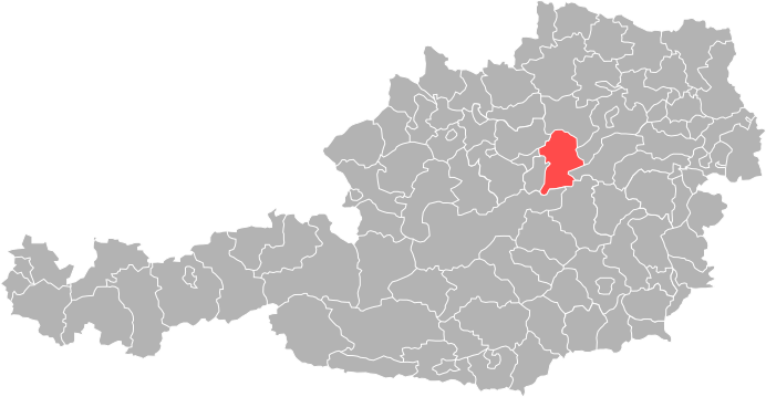
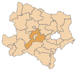
Мельк (Melk District, Bezirk Melk)

 Hiking in Мельк
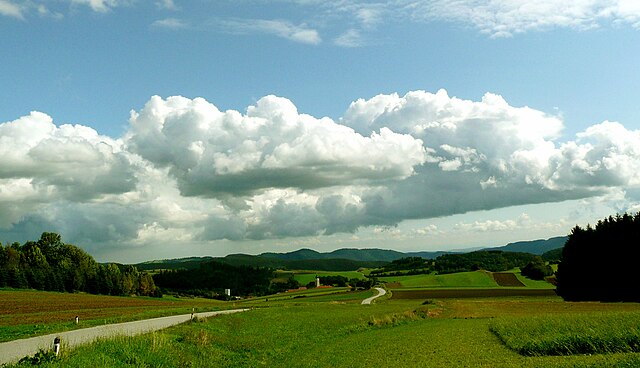
The Melk District, located in Lower Austria, is an excellent destination for hiking enthusiasts. This region is characterized by its scenic landscapes, rich history, and diverse trails suitable for various skill levels. Here are some highlights about hiking in the Melk District:
Scenic Trails
-
Danube River Trails: The renowned Danube River meanders through this district, offering picturesque hiking trails that follow the riverbanks. These paths provide stunning views of the river, vineyards, and surrounding hills.
-
Wachau Valley: Known for its UNESCO World Heritage status, the Wachau Valley features a network of trails that provide access to charming villages, terraced vineyards, and historic sites such as medieval castles and monasteries. The section between Krems and Melk is particularly popular.
-
Nature Reserves and Parks: The area includes several nature reserves, such as the Naturpark Jauerling-Wachau, which offers a range of hiking opportunities with well-marked routes that allow you to explore the natural beauty of the region, including forests, meadows, and wildlife.
Historical Sites
-
Melk Abbey: A must-visit while hiking in the area, this Benedictine abbey is a stunning example of Baroque architecture and sits atop a hill overlooking the town of Melk. Many trails in the vicinity lead to and from the abbey, providing both recreational and educational experiences.
-
Ruins of Dürnstein Castle: Another notable landmark is the ruins of Dürnstein Castle. The hike to the ruins offers breathtaking views of the Wachau Valley and the Danube River.
Difficulty Levels
Hiking routes in the Melk District cater to a variety of skill levels, from easy, family-friendly walks to more challenging uphill treks. Trail markers are generally clear, making navigation straightforward for hikers.
Best Time to Hike
- Spring and Fall: These seasons are typically the best times to hike in the Melk District, as the weather is mild, and the landscapes are especially beautiful, with blooming flowers in the spring and vibrant autumn colors.
Additional Tips
-
Map and Information: Before heading out, consider obtaining a local hiking map or guidebook, or checking online resources for detailed trail information.
-
Stay Hydrated: Always carry enough water, especially during warmer months, as some trails can be longer and more exposed to the sun.
-
Local Wines and Cuisine: After a day of hiking, treat yourself to local wines and traditional Austrian cuisine at the many inns and restaurants in the area.
Hiking in the Melk District offers a unique combination of natural beauty, cultural heritage, and recreational opportunities, making it a great destination for outdoor enthusiasts. Enjoy your adventure!
- Страна:

- Код автомобильного номера: ME
- Координаты: 48° 12' 0" N, 15° 12' 14" E


- GPS треки (wikiloc): [Ссылка]
- Высота над уровнем моря: 220 м m
- Площадь: 1013.62 кв.км
- Веб сайт: http://www.noel.gv.at/service/bh/me/bhme.htm
- Википедия русская: wiki(ru)
- Википедия английская: wiki(en)
- Википедия национальная: wiki(de)
- Хранилище Wikidata: Wikidata: Q261942
- Катеория в википедии: [Ссылка]
- код Freebase: [/m/05q4_6]
- код GeoNames: Альт: [2771680]
- код VIAF: Альт: [150271931]
- код GND: Альт: [10007419-4]
- идентификатор местоположения ArchINFORM: [14634]
- код LCNAF: Альт: [n97122083]
Включает регионы:
Кильб
Hiking in Кильб
Kilb, also known as Kilb in Scottish Gaelic, is a beautiful location that offers various hiking opportunities, often surrounded by stunning natural landscapes. While specific trails may vary depending on the area, here are some general tips and highlights for hiking in Kilb:...
- Страна:
- Почтовый код: 3233
- Телефонный код: 02748
- Код автомобильного номера: ME
- Координаты: 48° 6' 0" N, 15° 24' 20" E
- GPS треки (wikiloc): [Ссылка]
- Высота над уровнем моря: 300 м m
- Площадь: 45.18 кв.км
- Население: 2543
- Веб сайт: [Ссылка]
Целькинг-Мацлайнсдорф
Hiking in Целькинг-Мацлайнсдорф
Zelking-Matzleinsdorf is a small community in Austria, located in the state of Lower Austria. It's situated not far from the larger town of Krems an der Donau, which makes it a great starting point for exploring the beautiful landscapes of the region. Here are some highlights regarding hiking in and around Zelking-Matzleinsdorf:...
- Страна:
- Почтовый код: 3393
- Телефонный код: 02752
- Код автомобильного номера: ME
- Координаты: 48° 11' 0" N, 15° 15' 30" E
- GPS треки (wikiloc): [Ссылка]
- Высота над уровнем моря: 238 м m
- Площадь: 21.19 кв.км
- Население: 1214
- Веб сайт: [Ссылка]

Мариа-Таферль
Hiking in Мариа-Таферль
Maria Taferl, a picturesque village located in the Wachau region of Austria, is an excellent destination for hiking enthusiasts. The area is renowned for its stunning landscapes, rolling hills, vineyards, and scenic views, particularly of the Danube River....
- Страна:
- Почтовый код: 3672
- Телефонный код: 07413
- Код автомобильного номера: ME
- Координаты: 48° 13' 36" N, 15° 9' 35" E
- GPS треки (wikiloc): [Ссылка]
- Высота над уровнем моря: 443 м m
- Площадь: 12.17 кв.км
- Население: 912
- Веб сайт: [Ссылка]

Пёхларн
Hiking in Пёхларн
Pöchlarn, located in Lower Austria along the banks of the Danube River, offers a picturesque setting for hiking enthusiasts. The region is characterized by its scenic landscapes, including rolling hills, dense forests, and riverside trails. Here are some key points to consider if you're thinking about hiking in and around Pöchlarn:...
- Страна:
- Почтовый код: 3380
- Телефонный код: 02757
- Код автомобильного номера: ME
- Координаты: 48° 12' 0" N, 15° 12' 0" E
- GPS треки (wikiloc): [Ссылка]
- Высота над уровнем моря: 216 м m
- Площадь: 17.92 кв.км
- Население: 3912
- Веб сайт: [Ссылка]

Ибс-на-Дунае
Hiking in Ибс-на-Дунае
Ybbs an der Donau is a charming town situated in Lower Austria, nestled along the banks of the Danube River. It offers a variety of hiking opportunities that cater to different skill levels, with scenic views, lush landscapes, and rich cultural experiences. Here are some highlights and tips for hiking in Ybbs:...
- Страна:
- Почтовый код: 3370
- Телефонный код: 07412
- Код автомобильного номера: ME
- Координаты: 48° 10' 0" N, 15° 4' 0" E
- GPS треки (wikiloc): [Ссылка]
- Высота над уровнем моря: 224 м m
- Площадь: 23.82 кв.км
- Население: 5653
- Веб сайт: [Ссылка]


Ноймаркт-на-Ибсе
Hiking in Ноймаркт-на-Ибсе
Neumarkt an der Ybbs is a charming town in Austria, located in the region of Lower Austria. It is an excellent starting point for hiking enthusiasts due to its picturesque landscapes and proximity to the Ybbs River and the surrounding hills. Here are some key highlights for hiking in and around Neumarkt an der Ybbs:...
- Страна:
- Почтовый код: 3371
- Телефонный код: 07412
- Код автомобильного номера: ME
- Координаты: 48° 8' 0" N, 15° 3' 0" E
- GPS треки (wikiloc): [Ссылка]
- Высота над уровнем моря: 231 м m
- Площадь: 9.32 кв.км
- Население: 1899
- Веб сайт: [Ссылка]
Петценкирхен
Hiking in Петценкирхен
Petzenkirchen, located in Austria, is a beautiful area for hiking enthusiasts. Surrounded by picturesque landscapes, the region offers various trails that cater to different skill levels, from leisurely strolls to more challenging hikes. Here are some highlights about hiking in Petzenkirchen:...
- Страна:
- Почтовый код: 3252
- Телефонный код: 07416
- Код автомобильного номера: ME
- Координаты: 48° 8' 44" N, 15° 9' 21" E
- GPS треки (wikiloc): [Ссылка]
- Высота над уровнем моря: 258 м m
- Площадь: 2.89 кв.км
- Население: 1311
- Веб сайт: [Ссылка]

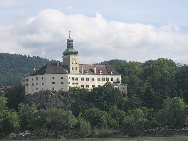
Мельк
Hiking in Мельк
Melk, located in Austria, is known for its stunning landscapes along the Danube River and its rich historical background, most notably the Melk Abbey. Hiking in and around Melk offers a variety of trails suited for different skill levels, with beautiful views of the countryside, vineyards, and the river itself....
- Страна:
- Почтовый код: 3390
- Телефонный код: 0 27 52
- Код автомобильного номера: ME
- Координаты: 48° 13' 37" N, 15° 20' 38" E
- GPS треки (wikiloc): [Ссылка]
- Высота над уровнем моря: 213 м m
- Площадь: 25.71 кв.км
- Население: 5308
- Веб сайт: [Ссылка]

Пёгсталль
Hiking in Пёгсталль
Pöggstall, located in Lower Austria, is a charming small town that offers a variety of hiking opportunities amidst beautiful natural scenery. The area is characterized by rolling hills, dense forests, and stunning views of the surrounding countryside, making it an appealing destination for hikers of all levels....
- Страна:
- Почтовый код: 3650
- Телефонный код: 02758
- Код автомобильного номера: ME
- Координаты: 48° 19' 0" N, 15° 12' 6" E
- GPS треки (wikiloc): [Ссылка]
- Высота над уровнем моря: 462 м m
- Площадь: 58.92 кв.км
- Население: 2435
- Веб сайт: [Ссылка]

Артштеттен-Пёбринг
Hiking in Артштеттен-Пёбринг
Artstetten-Pöbring, located in the district of Melk, Austria, is known for its beautiful landscapes and an array of hiking opportunities. The region is characterized by rolling hills, lush forests, and scenic views of the Danube River. Here are some details and tips about hiking in this picturesque area:...
- Страна:
- Почтовый код: 3661
- Телефонный код: 07413
- Код автомобильного номера: ME
- Координаты: 48° 14' 33" N, 15° 12' 15" E
- GPS треки (wikiloc): [Ссылка]
- Высота над уровнем моря: 395 м m
- Площадь: 27.32 кв.км
- Население: 1184
- Веб сайт: [Ссылка]
Перзенбойг-Готсдорф
Hiking in Перзенбойг-Готсдорф
Persenbeug-Gottsdorf is a charming area located in Austria, known for its picturesque landscapes and variety of outdoor activities, including hiking. Nestled along the Danube River, this region offers stunning views of the surrounding hills, forests, and water landscapes. Here are some key points about hiking in Persenbeug-Gottsdorf:...
- Страна:
- Почтовый код: 3680
- Телефонный код: 07412
- Код автомобильного номера: ME
- Координаты: 48° 10' 0" N, 15° 4' 0" E
- GPS треки (wikiloc): [Ссылка]
- Высота над уровнем моря: 230 м m
- Площадь: 8.32 кв.км
- Население: 2201
- Веб сайт: [Ссылка]

Вайтен
Hiking in Вайтен
Weiten is a charming area known for its scenic landscapes and outdoor activities, particularly hiking. While specific trails and routes can depend on the exact region you're referring to (as there may be multiple places named Weiten), here are some general tips and insights for hiking in scenic areas similar to that name:...
- Страна:
- Почтовый код: 3653
- Телефонный код: 02758
- Код автомобильного номера: ME
- Координаты: 48° 17' 30" N, 15° 16' 0" E
- GPS треки (wikiloc): [Ссылка]
- Высота над уровнем моря: 349 м m
- Площадь: 28.53 кв.км
- Население: 1094
- Веб сайт: [Ссылка]
Бергланд
- коммуна в Австрии
Hiking in Бергланд
Bergland, Austria, is a beautiful region that offers a fantastic hiking experience, characterized by its stunning alpine landscapes, lush valleys, and charming villages. Here are some highlights and tips for hiking in Bergland:...
- Страна:
- Почтовый код: 3254
- Телефонный код: 07416
- Код автомобильного номера: ME
- Координаты: 48° 9' 20" N, 15° 10' 56" E
- GPS треки (wikiloc): [Ссылка]
- Высота над уровнем моря: 252 м m
- Площадь: 33.89 кв.км
- Население: 1909
- Веб сайт: [Ссылка]
Шоллах
Hiking in Шоллах
Schollach is a picturesque area located in the Black Forest region of Germany. While specific information about trails in Schollach may not be as readily available as in more famous locations, the Black Forest is known for its stunning landscapes, dense forests, and a variety of hiking trails for all skill levels....
- Страна:
- Почтовый код: 3382
- Телефонный код: 02754
- Код автомобильного номера: ME
- Координаты: 48° 11' 0" N, 15° 21' 0" E
- GPS треки (wikiloc): [Ссылка]
- Высота над уровнем моря: 241 м m
- Площадь: 19.69 кв.км
- Население: 976
- Веб сайт: [Ссылка]

Шёнбюэль-Агсбах
Hiking in Шёнбюэль-Агсбах
Schönbühel-Aggsbach, located in the beautiful Wachau Valley in Austria, is a great destination for hiking enthusiasts. The region is known for its stunning landscapes, vineyards, and the Danube River, providing a picturesque backdrop for outdoor activities....
- Страна:
- Телефонный код: 02753
- Код автомобильного номера: ME
- Координаты: 48° 17' 31" N, 15° 24' 43" E
- GPS треки (wikiloc): [Ссылка]
- Высота над уровнем моря: 210 м m
- Площадь: 28.37 кв.км
- Население: 981
- Веб сайт: [Ссылка]
Лосдорф
- ярмарочная коммуна в земле Нижняя Австрия
Hiking in Лосдорф
Loosdorf, a small village located in Lower Austria, offers some beautiful hiking opportunities for outdoor enthusiasts. The area's natural landscapes are characterized by rolling hills, vineyards, and lush forests, making it suitable for both leisurely walks and more strenuous hikes....
- Страна:
- Почтовый код: 3382
- Телефонный код: 02754
- Код автомобильного номера: ME
- Координаты: 48° 12' 2" N, 15° 24' 4" E
- GPS треки (wikiloc): [Ссылка]
- Высота над уровнем моря: 234 м m
- Площадь: 11.91 кв.км
- Население: 3794
- Веб сайт: [Ссылка]

Манк
Hiking in Манк
Mank is a fictional location as far as current hiking destinations go, but I can provide you an overview of what to consider when hiking in a general area you might be referring to. If you're thinking of a specific region or park, please let me know!...
- Страна:
- Почтовый код: 3240
- Телефонный код: 0 27 55
- Код автомобильного номера: ME
- Координаты: 48° 6' 39" N, 15° 20' 28" E
- GPS треки (wikiloc): [Ссылка]
- Высота над уровнем моря: 295 м m
- Площадь: 33.38 кв.км
- Население: 3219
- Веб сайт: [Ссылка]

Блинденмаркт
Hiking in Блинденмаркт
Blindenmarkt, located in Austria, is a charming small town surrounded by picturesque landscapes that are ideal for hiking enthusiasts. The region offers a variety of trails that cater to different skill levels, from leisurely walks to more challenging hikes....
- Страна:
- Почтовый код: 3372
- Телефонный код: 07473
- Код автомобильного номера: ME
- Координаты: 48° 7' 43" N, 14° 59' 21" E
- GPS треки (wikiloc): [Ссылка]
- Высота над уровнем моря: 246 м m
- Площадь: 17.05 кв.км
- Население: 2712
- Веб сайт: [Ссылка]
Крумнусбаум
Hiking in Крумнусбаум
Krummnußbaum is a picturesque area in Austria, situated near the Danube River, which offers a variety of hiking opportunities. Here are some highlights and tips for hiking in and around Krummnußbaum:...
- Страна:
- Почтовый код: 3375
- Телефонный код: 02757
- Код автомобильного номера: ME
- Координаты: 48° 12' 27" N, 15° 9' 53" E
- GPS треки (wikiloc): [Ссылка]
- Высота над уровнем моря: 219 м m
- Площадь: 10.07 кв.км
- Население: 1500
- Веб сайт: [Ссылка]

Тексингталь
Hiking in Тексингталь
Texingtal, located in the Austrian Alps, is a beautiful valley that offers various hiking opportunities for both beginner and experienced hikers. The region is renowned for its stunning landscapes, including lush meadows, rugged mountain terrain, and clear streams. Here are some key points to consider when hiking in Texingtal:...
- Страна:
- Почтовый код: 3242
- Телефонный код: 02755
- Код автомобильного номера: ME
- Координаты: 48° 2' 50" N, 15° 19' 20" E
- GPS треки (wikiloc): [Ссылка]
- Высота над уровнем моря: 370 м m
- Площадь: 32.45 кв.км
- Население: 1615
- Веб сайт: [Ссылка]


Исперталь
Hiking in Исперталь
Yspertal is a picturesque valley located in Austria, known for its stunning natural landscapes, diverse flora and fauna, and charming villages. It offers a variety of hiking options suitable for different skill levels, making it a great destination for both beginners and experienced hikers....
- Страна:
- Почтовый код: 3683
- Телефонный код: 07415
- Код автомобильного номера: ME
- Координаты: 48° 17' 0" N, 15° 3' 50" E
- GPS треки (wikiloc): [Ссылка]
- Высота над уровнем моря: 498 м m
- Площадь: 47.67 кв.км
- Население: 2007
- Веб сайт: [Ссылка]
Дорфштеттен
Hiking in Дорфштеттен
Dorfstetten, located in the beautiful region of Lower Austria, offers a variety of hiking opportunities amidst its picturesque landscapes. Here are some highlights for hiking in and around Dorfstetten:...
- Страна:
- Почтовый код: 4392
- Телефонный код: 07260
- Код автомобильного номера: ME
- Координаты: 48° 19' 34" N, 14° 58' 55" E
- GPS треки (wikiloc): [Ссылка]
- Высота над уровнем моря: 740 м m
- Площадь: 33.09 кв.км
- Население: 584
- Веб сайт: [Ссылка]


Клайн-Пёхларн
Hiking in Клайн-Пёхларн
Klein-Pöchlarn is a small municipality located in the Lower Austria region of Austria, near the Danube River. The area is known for its beautiful landscapes and scenic trails that make it a great destination for hiking enthusiasts....
- Страна:
- Почтовый код: 3660
- Телефонный код: 07413
- Код автомобильного номера: ME
- Координаты: 48° 13' 0" N, 15° 13' 0" E
- GPS треки (wikiloc): [Ссылка]
- Высота над уровнем моря: 223 м m
- Площадь: 6.9 кв.км
- Население: 991
- Веб сайт: [Ссылка]
Дункельштайнервальд
Hiking in Дункельштайнервальд
Dunkelsteinerwald is a picturesque region located in Austria, specifically in the municipality of Dunkelsteinerwald, which is part of the larger Lower Austria region. The area is characterized by its lush forests, rolling hills, and scenic landscapes, making it a fantastic destination for hiking enthusiasts....
- Страна:
- Почтовый код: 3392
- Телефонный код: 02753
- Код автомобильного номера: ME
- Координаты: 48° 18' 24" N, 15° 28' 20" E
- GPS треки (wikiloc): [Ссылка]
- Высота над уровнем моря: 585 м m
- Площадь: 54.19 кв.км
- Население: 2390
- Веб сайт: [Ссылка]
Голлинг-ан-дер-Эрлауф
Hiking in Голлинг-ан-дер-Эрлауф
Golling an der Erlauf is a beautiful area located in the Austrian state of Salzburg, known for its stunning landscapes, picturesque nature, and a variety of hiking trails suitable for different skill levels....
- Страна:
- Почтовый код: 3381
- Телефонный код: 02757
- Код автомобильного номера: ME
- Координаты: 48° 12' 0" N, 15° 11' 0" E
- GPS треки (wikiloc): [Ссылка]
- Высота над уровнем моря: 215 м m
- Площадь: 2.71 кв.км
- Население: 1514
- Веб сайт: [Ссылка]
Раксендорф
Hiking in Раксендорф
Raxendorf is a picturesque village located in the Austrian province of Lower Austria, known for its stunning natural landscapes and hiking opportunities. The area is characterized by lush forests, rolling hills, and scenic views, making it an excellent destination for outdoor enthusiasts....
- Страна:
- Почтовый код: 3654
- Телефонный код: 02758
- Код автомобильного номера: ME
- Координаты: 48° 20' 27" N, 15° 16' 29" E
- GPS треки (wikiloc): [Ссылка]
- Высота над уровнем моря: 506 м m
- Площадь: 36.24 кв.км
- Население: 1050
- Веб сайт: [Ссылка]
Санкт-Леонхард-ам-Форст
Hiking in Санкт-Леонхард-ам-Форст
Sankt Leonhard am Forst, a quaint village located in Lower Austria, is surrounded by stunning natural landscapes, making it a fantastic hiking destination. The area is characterized by lush forests, rolling hills, and scenic views of the local countryside, providing a peaceful setting for outdoor enthusiasts....
- Страна:
- Почтовый код: 3243
- Телефонный код: 02756
- Код автомобильного номера: ME
- Координаты: 48° 8' 30" N, 15° 17' 0" E
- GPS треки (wikiloc): [Ссылка]
- Высота над уровнем моря: 249 м m
- Площадь: 43.51 кв.км
- Население: 2989
- Веб сайт: [Ссылка]
Хюрм
Hiking in Хюрм
Hürm, a district in the city of Mönchengladbach, Germany, is not widely known as a major hiking destination, but it does offer some pleasant outdoor experiences for those looking to explore the local nature. While the area itself may not have extensive hiking trails, you can find various opportunities in the surrounding regions, including nearby parks and green spaces....
- Страна:
- Почтовый код: 3383
- Телефонный код: 02754
- Код автомобильного номера: ME
- Координаты: 48° 9' 21" N, 15° 24' 43" E
- GPS треки (wikiloc): [Ссылка]
- Высота над уровнем моря: 274 м m
- Площадь: 36.09 кв.км
- Население: 1828
- Веб сайт: [Ссылка]
Санкт-Мартин-Карлсбах
Hiking in Санкт-Мартин-Карлсбах
Sankt Martin-Karlsbach is located in the beautiful region of the Palatinate Forest in Germany, which is renowned for its stunning landscapes, diverse hiking trails, and rich natural beauty. Here are some details about hiking in the area:...
- Страна:
- Почтовый код: 3376
- Телефонный код: 07412
- Код автомобильного номера: ME
- Координаты: 48° 9' 50" N, 15° 1' 20" E
- GPS треки (wikiloc): [Ссылка]
- Высота над уровнем моря: 312 м m
- Площадь: 24.91 кв.км
- Население: 1659
- Веб сайт: [Ссылка]

Эммерсдорф-на-Дунае
Hiking in Эммерсдорф-на-Дунае
Emmersdorf an der Donau is a picturesque village located in Austria, offering beautiful landscapes and a variety of hiking opportunities along the Danube River. The region is characterized by its stunning views, rich history, and well-maintained hiking trails suitable for hikers of all levels....
- Страна:
- Почтовый код: 3644
- Телефонный код: 02752
- Код автомобильного номера: ME
- Координаты: 48° 14' 26" N, 15° 20' 9" E
- GPS треки (wikiloc): [Ссылка]
- Высота над уровнем моря: 211 м m
- Площадь: 29.81 кв.км
- Население: 1778
- Веб сайт: [Ссылка]


Эрлауф
Hiking in Эрлауф
Erlauf is a picturesque region located in Austria, offering beautiful landscapes and a variety of hiking opportunities for outdoor enthusiasts. The area is particularly known for its diverse terrain, including forests, mountains, and serene lakes, making it ideal for hikers of all skill levels....
- Страна:
- Почтовый код: 3253
- Телефонный код: 02757
- Код автомобильного номера: ME
- Координаты: 48° 11' 2" N, 15° 11' 3" E
- GPS треки (wikiloc): [Ссылка]
- Высота над уровнем моря: 225 м m
- Площадь: 9.67 кв.км
- Население: 1069
- Веб сайт: [Ссылка]
Рупрехтсхофен
Hiking in Рупрехтсхофен
Ruprechtshofen is a charming village located in Austria, surrounded by the beautiful landscapes of the Salzkammergut region. This area is characterized by its rolling hills, dense forests, and stunning alpine scenery, making it a great destination for hiking enthusiasts. Here are some key points to consider when hiking in and around Ruprechtshofen:...
- Страна:
- Почтовый код: 3244
- Телефонный код: 02756
- Код автомобильного номера: ME
- Координаты: 48° 8' 10" N, 15° 16' 40" E
- GPS треки (wikiloc): [Ссылка]
- Высота над уровнем моря: 247 м m
- Площадь: 30.57 кв.км
- Население: 2315
- Веб сайт: [Ссылка]

Бишофштеттен
- коммуна в Австрии
Hiking in Бишофштеттен
Bischofstetten is a picturesque area located in Austria, surrounded by beautiful landscapes that make it a great destination for hiking enthusiasts. The region is characterized by rolling hills, lush forests, and charming meadows, offering various hiking trails suitable for different skill levels....
- Страна:
- Почтовый код: 3232
- Телефонный код: 02748
- Код автомобильного номера: ME
- Координаты: 48° 7' 24" N, 15° 28' 12" E
- GPS треки (wikiloc): [Ссылка]
- Высота над уровнем моря: 274 м m
- Площадь: 19 кв.км
- Население: 1176
- Веб сайт: [Ссылка]
Санкт-Освальд
Hiking in Санкт-Освальд
Sankt Oswald in Lower Austria is a beautiful area for hiking, offering a mix of lush forests, rolling hills, and serene landscapes. Here are some highlights and details about hiking in this region:...
- Страна:
- Почтовый код: 3684
- Телефонный код: 07415
- Код автомобильного номера: ME
- Координаты: 48° 16' 0" N, 15° 2' 10" E
- GPS треки (wikiloc): [Ссылка]
- Высота над уровнем моря: 658 м m
- Площадь: 32.15 кв.км
- Население: 1124
- Веб сайт: [Ссылка]
Хофамт-Приль
Hiking in Хофамт-Приль
Hofamt Priel is a picturesque area in the Lower Austria region of Austria, known for its beautiful landscapes and hiking opportunities. Nestled at the foothills of the Alps, the area offers a variety of trails suitable for different skill levels, from casual walkers to experienced hikers....
- Страна:
- Почтовый код: 3681
- Телефонный код: 07412
- Код автомобильного номера: ME
- Координаты: 48° 11' 50" N, 15° 4' 30" E
- GPS треки (wikiloc): [Ссылка]
- Высота над уровнем моря: 240 м m
- Площадь: 39.63 кв.км
- Население: 1675
- Веб сайт: [Ссылка]

Кирнберг-ан-дер-Манк
Hiking in Кирнберг-ан-дер-Манк
Kirnberg an der Mank is a picturesque village located in Lower Austria, surrounded by beautiful landscapes that offer excellent opportunities for hiking. The region is characterized by rolling hills, lush forests, and charming countryside, making it a great destination for outdoor enthusiasts....
- Страна:
- Почтовый код: 3241
- Телефонный код: 02755
- Код автомобильного номера: ME
- Координаты: 48° 4' 15" N, 15° 19' 20" E
- GPS треки (wikiloc): [Ссылка]
- Высота над уровнем моря: 341 м m
- Площадь: 17.67 кв.км
- Население: 1070
- Веб сайт: [Ссылка]
Мюнихрайт-Лаймбах
Hiking in Мюнихрайт-Лаймбах
Münichreith-Laimbach is a charming area in Austria that offers some beautiful hiking opportunities, set against a backdrop of scenic landscapes, woodlands, and gentle hills. This region, located in the district of Melk in Lower Austria, is ideal for hikers of various skill levels....
- Страна:
- Почтовый код: 3662, 3663
- Код автомобильного номера: ME
- Координаты: 48° 24' 0" N, 15° 18' 0" E
- GPS треки (wikiloc): [Ссылка]
- Высота над уровнем моря: 675 м m
- Площадь: 38.82 кв.км
- Население: 1662
- Веб сайт: [Ссылка]


Лайбен
Hiking in Лайбен
Leiben is a picturesque village located in the Lower Austria region of Austria. While it may not be as widely known as some larger hiking destinations, it offers charming landscapes and access to trails that can be enjoyed by hikers of varying skill levels....
- Страна:
- Почтовый код: 3652
- Телефонный код: 02752
- Код автомобильного номера: ME
- Координаты: 48° 14' 36" N, 15° 16' 28" E
- GPS треки (wikiloc): [Ссылка]
- Высота над уровнем моря: 285 м m
- Площадь: 12.53 кв.км
- Население: 1362
- Веб сайт: [Ссылка]


Марбах-на-Дунае
Hiking in Марбах-на-Дунае
Marbach an der Donau is a charming village located along the Danube River in Austria, known for its picturesque landscapes and outdoor activities, including hiking. The area is surrounded by lush forests, rolling hills, and stunning views of the river, making it a great destination for nature enthusiasts....
- Страна:
- Почтовый код: 3671
- Телефонный код: 07413
- Код автомобильного номера: ME
- Координаты: 48° 13' 0" N, 15° 9' 0" E
- GPS треки (wikiloc): [Ссылка]
- Высота над уровнем моря: 219 м m
- Площадь: 10.66 кв.км
- Население: 1677
- Веб сайт: [Ссылка]
Нёхлинг
Hiking in Нёхлинг
Nöchling is a beautiful area located in Austria, particularly in the region of Upper Austria. It is known for its stunning landscapes, with rolling hills, forests, and rivers, making it an excellent destination for hiking enthusiasts....
- Страна:
- Почтовый код: 3691
- Телефонный код: 07414
- Код автомобильного номера: ME
- Координаты: 48° 13' 25" N, 14° 58' 58" E
- GPS треки (wikiloc): [Ссылка]
- Высота над уровнем моря: 533 м m
- Площадь: 19.59 кв.км
- Население: 1077
- Веб сайт: [Ссылка]
Граничит с регионами:

Шайбс
Hiking in Шайбс
Scheibbs District, located in the Lower Austria region of Austria, is known for its beautiful landscapes, rich cultural heritage, and a variety of hiking opportunities. Here are some highlights for hiking in this area:...
- Страна:
- Код автомобильного номера: SB
- Координаты: 48° 0' 40" N, 15° 5' 20" E
- GPS треки (wikiloc): [Ссылка]
- Высота над уровнем моря: 463 м m
- Площадь: 1023 кв.км
- Веб сайт: [Ссылка]

Санкт-Пёльтен
Hiking in Санкт-Пёльтен
Sankt Pölten-Land District, located in the Lower Austria region of Austria, is a scenic area that offers numerous hiking opportunities amidst beautiful landscapes, cultural heritage, and nature reserves. Here are some highlights and tips for hiking in this district:...
- Страна:
- Код автомобильного номера: PL
- Координаты: 48° 10' 59" N, 15° 40' 1" E
- GPS треки (wikiloc): [Ссылка]
- Высота над уровнем моря: 313 м m
- Площадь: 1121.61 кв.км
- Веб сайт: [Ссылка]

Амштеттен
Hiking in Амштеттен
Amstetten District, located in the Lower Austria region of Austria, offers a variety of hiking opportunities for outdoor enthusiasts. The region is characterized by its diverse landscapes, which include hills, forests, and charming rural scenery, making it an appealing destination for both casual walkers and experienced hikers....
- Страна:
- Столица: Амштеттен
- Код автомобильного номера: AM
- Координаты: 48° 7' 0" N, 14° 52' 0" E
- GPS треки (wikiloc): [Ссылка]
- Высота над уровнем моря: 602 м m
- Площадь: 1187.97 кв.км
- Население: 115676
- Веб сайт: [Ссылка]

Цветль
Hiking in Цветль
Zwettl District, located in the Waldviertel region of Austria, offers a picturesque setting for hiking enthusiasts. The area is characterized by its diverse landscapes, including forests, rolling hills, and charming villages, making it a great destination for both casual walkers and experienced hikers....
- Страна:
- Код автомобильного номера: ZT
- Координаты: 48° 34' 52" N, 15° 9' 7" E
- GPS треки (wikiloc): [Ссылка]
- Высота над уровнем моря: 665 м m
- Площадь: 1399.76 кв.км
- Веб сайт: [Ссылка]