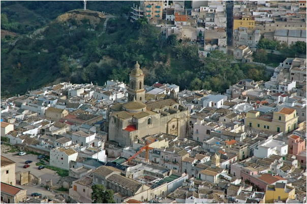
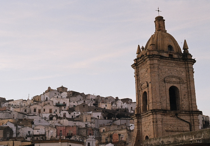
Мильонико (Miglionico, Miglionico)
.svg)
- коммуна Италии
 Hiking in Мильонико
Miglionico is a charming village located in the Basilicata region of southern Italy, surrounded by beautiful landscapes and offering a variety of outdoor activities, including hiking. The area is characterized by its rolling hills, vineyards, and olive groves, as well as its rich history and cultural heritage.
Hiking Opportunities
-
Local Trails: There are several hiking trails around Miglionico that cater to different skill levels. These trails offer stunning views of the surrounding countryside, old stone pathways, and encounters with local flora and fauna.
-
Historic Routes: Some trails may take you through areas of historical significance, allowing you to explore ancient ruins or traditional villages. The architecture and landscapes reflect the rich cultural tapestry of the region.
-
Wine and Olive Oil Trails: Given the region's agricultural heritage, some hikes may also combine scenic walking with opportunities to visit local vineyards and olive oil producers, where you can sample local products.
-
Nearby Natural Parks: Close to Miglionico, you may find natural parks or protected areas, such as the Pollino National Park, where more extensive hiking routes and varied terrains are available. These parks often feature a range of ecosystems and breathtaking vistas.
Tips for Hiking in Miglionico
-
Best Time to Hike: The ideal times for hiking in this region are during the spring (April to June) and fall (September to October), when temperatures are mild and the scenery is particularly beautiful.
-
Preparation: Make sure to bring enough water, snacks, and sun protection. A good pair of hiking boots is essential due to the varied terrain.
-
Maps and Guides: Consider obtaining a map or hiring a local guide who knows the trails well. This can enhance your experience and ensure your safety.
-
Respect Nature and Culture: As with any outdoor activity, it's important to respect the natural environment and local traditions. Leave no trace, and be mindful of wildlife and local people's way of life.
Conclusion
Hiking in and around Miglionico provides not only a physical activity but also a cultural experience, letting you connect with the stunning landscapes, rich history, and local gastronomy of Basilicata. Whether you're an experienced hiker or just looking for a leisurely walk, you will find plenty to enjoy in this hidden gem of Italy.
- Страна:

- Почтовый код: 75010
- Телефонный код: 0835
- Код автомобильного номера: MT
- Координаты: 40° 34' 0" N, 16° 30' 0" E


- GPS треки (wikiloc): [Ссылка]
- Высота над уровнем моря: 465 м m
- Площадь: 88.84 кв.км
- Население: 2454
- Веб сайт: http://www.comune.miglionico.mt.it
- Википедия русская: wiki(ru)
- Википедия английская: wiki(en)
- Википедия национальная: wiki(it)
- Хранилище Wikidata: Wikidata: Q52320
- Галерея изображений в википедии: [Ссылка]
- Катеория в википедии: [Ссылка]
- код Freebase: [/m/0fgv4f]
- код Freebase: [/m/0fgv4f]
- код GeoNames: Альт: [6537648]
- код GeoNames: Альт: [6537648]
- код VIAF: Альт: [123351575]
- код VIAF: Альт: [123351575]
- ID отношения в OpenStreetMap: [40595]
- ID отношения в OpenStreetMap: [40595]
- код Цифрового атласа Римской империи: [29240]
- код Цифрового атласа Римской империи: [29240]
- код ISTAT: 077015
- код ISTAT: 077015
- кадастровый код Италии: F201
- кадастровый код Италии: F201
Граничит с регионами:


Матера
- коммуна Италии
Hiking in Матера
Hiking in Matera, Italy, offers a unique blend of ancient history, stunning landscapes, and diverse trails. Nestled in the Basilicata region, Matera is famous for its "Sassi" districts—cave dwellings that have been inhabited for thousands of years. Here are some key points you should consider when hiking in and around Matera:...
- Страна:
- Почтовый код: 75100
- Телефонный код: 0835
- Код автомобильного номера: MT
- Координаты: 40° 40' 0" N, 16° 36' 0" E
- GPS треки (wikiloc): [Ссылка]
- Высота над уровнем моря: 401 м m
- Площадь: 392.09 кв.км
- Население: 60351
- Веб сайт: [Ссылка]


Феррандина
- коммуна Италии
Hiking in Феррандина
Ferrandina is a charming town located in the Basilicata region of southern Italy, surrounded by beautiful landscapes that offer various hiking opportunities. Here are some key points to consider when hiking in and around Ferrandina:...
- Страна:
- Почтовый код: 75013
- Телефонный код: 0835
- Код автомобильного номера: MT
- Координаты: 40° 30' 0" N, 16° 27' 0" E
- GPS треки (wikiloc): [Ссылка]
- Высота над уровнем моря: 420 м m
- Площадь: 218.11 кв.км
- Население: 8727
- Веб сайт: [Ссылка]
Гроттоле
- коммуна Италии
Hiking in Гроттоле
Grottole is a charming village located in the Basilicata region of Southern Italy, known for its beautiful landscapes and rich historical heritage. It's a great spot for hiking enthusiasts looking to explore the natural beauty and cultural sites of this lesser-known area. Here are some key points about hiking in and around Grottole:...
- Страна:
- Почтовый код: 75010
- Телефонный код: 0835
- Код автомобильного номера: MT
- Координаты: 40° 36' 12" N, 16° 22' 42" E
- GPS треки (wikiloc): [Ссылка]
- Высота над уровнем моря: 481 м m
- Площадь: 117.15 кв.км
- Население: 2116
- Веб сайт: [Ссылка]

Монтескальозо
- коммуна Италии
Hiking in Монтескальозо
Montescaglioso is a charming town located in the Basilicata region of Southern Italy, known for its rich history and stunning landscapes. Hiking in and around Montescaglioso offers a great opportunity to explore the natural beauty of the area while experiencing its cultural heritage....
- Страна:
- Почтовый код: 75024
- Телефонный код: 0835
- Код автомобильного номера: MT
- Координаты: 40° 33' 0" N, 16° 40' 0" E
- GPS треки (wikiloc): [Ссылка]
- Высота над уровнем моря: 365 м m
- Площадь: 175.79 кв.км
- Население: 9877
- Веб сайт: [Ссылка]

Помарико
- коммуна Италии
Hiking in Помарико
Pomarico is a small town located in the Basilicata region of Italy, surrounded by beautiful landscapes that offer various opportunities for hiking and outdoor activities. While Pomarico itself is not a major hiking destination, it serves as a great starting point for exploring the surrounding areas, particularly the nearby hills and countryside....
- Страна:
- Почтовый код: 75016
- Телефонный код: 0835
- Код автомобильного номера: MT
- Координаты: 40° 31' 0" N, 16° 33' 0" E
- GPS треки (wikiloc): [Ссылка]
- Высота над уровнем моря: 459 м m
- Площадь: 129.67 кв.км
- Население: 4084
- Веб сайт: [Ссылка]