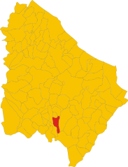
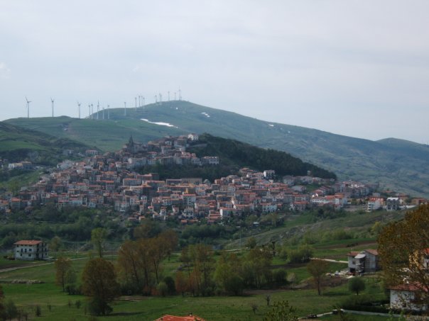
Монтаццоли (Montazzoli, Montazzoli)
.svg)
- коммуна Италии
 Hiking in Монтаццоли
Montazzoli is a charming village located in the Abruzzo region of Italy, known for its stunning landscapes and rich natural beauty. The surrounding area offers a variety of hiking opportunities for both beginners and experienced hikers.
Hikes and Trails
-
Nature Trails: There are several marked trails around Montazzoli that take you through forests, rolling hills, and traditional Abruzzese countryside. These trails often feature panoramic views of the surrounding mountains and valleys.
-
Cascate del Verde: A popular nearby destination is the Cascate del Verde, a beautiful waterfall that can be reached via hiking trails. The hike to the falls offers a mix of moderate terrain and breathtaking views, making it a rewarding experience.
-
Parco Nazionale della Majella: The Majella National Park is not too far from Montazzoli and offers extensive hiking routes. This park is home to rugged mountains, deep gorges, and diverse wildlife. Trails range from easy walks to challenging hikes, catering to all levels of experience.
Tips for Hiking in Montazzoli
- Weather: Check the weather conditions before heading out, as they can fluctuate, especially in mountainous areas.
- Equipment: Wear appropriate footwear, bring water, snacks, and a first aid kit, and consider carrying trekking poles for stability on uneven terrain.
- Local Guidance: If you're unfamiliar with the area, consider hiring a local guide or joining a group hike to discover hidden gems and learn more about the local flora and fauna.
Cultural Experience
Hiking in Montazzoli is not just about nature; you can also soak in the local culture. The village is known for its traditional cuisine, so make a point to enjoy local dishes at nearby restaurants after your hike.
Conclusion
Montazzoli offers an excellent base for hiking enthusiasts looking to explore the natural beauty of Abruzzo. Whether you're seeking leisure walks or more challenging treks, there's something for everyone in this picturesque part of Italy. Happy hiking!
- Страна:

- Почтовый код: 66030
- Телефонный код: 0872
- Код автомобильного номера: CH
- Координаты: 41° 57' 0" N, 14° 26' 0" E


- GPS треки (wikiloc): [Ссылка]
- Высота над уровнем моря: 850 м m
- Площадь: 39.46 кв.км
- Население: 930
- Веб сайт: http://www.comune.montazzoli.ch.it/
- Википедия русская: wiki(ru)
- Википедия английская: wiki(en)
- Википедия национальная: wiki(it)
- Хранилище Wikidata: Wikidata: Q51249
- Катеория в википедии: [Ссылка]
- код Freebase: [/m/0fg2_n]
- код GeoNames: Альт: [6537483]
- код VIAF: Альт: [235265398]
- ID отношения в OpenStreetMap: [41638]
- код ISTAT: 069051
- кадастровый код Италии: F433
Граничит с регионами:

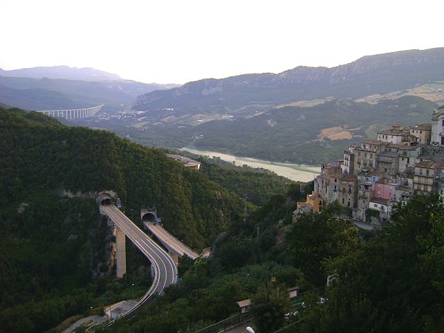
Монтеферранте
- коммуна Италии
Hiking in Монтеферранте
Monteferrante, located in the Abruzzo region of Italy, offers beautiful hiking opportunities surrounded by stunning scenery and rich natural biodiversity. Here are some highlights to consider for your hiking trip in Monteferrante:...
- Страна:
- Почтовый код: 66040
- Телефонный код: 0872
- Код автомобильного номера: CH
- Координаты: 41° 57' 0" N, 14° 23' 0" E
- GPS треки (wikiloc): [Ссылка]
- Высота над уровнем моря: 850 м m
- Площадь: 15.29 кв.км
- Население: 123
- Веб сайт: [Ссылка]


Атесса
- коммуна Италии
Hiking in Атесса
Atessa, located in the Abruzzo region of Italy, offers a range of hiking opportunities that showcase the area's beautiful landscapes, rich history, and cultural heritage. Here are some key points about hiking in Atessa:...
- Страна:
- Почтовый код: 66041
- Телефонный код: 0872
- Код автомобильного номера: CH
- Координаты: 42° 4' 0" N, 14° 27' 0" E
- GPS треки (wikiloc): [Ссылка]
- Высота над уровнем моря: 435 м m
- Площадь: 110.98 кв.км
- Население: 10580
- Веб сайт: [Ссылка]

Кастильоне-Мессер-Марино
- коммуна Италии
Hiking in Кастильоне-Мессер-Марино
Castiglione Messer Marino is a charming village in the Abruzzo region of Italy, known for its beautiful landscapes, rich history, and traditional architecture. The area is surrounded by the stunning scenery of the Abruzzo National Park and offers a variety of hiking opportunities for both novice and experienced hikers....
- Страна:
- Почтовый код: 66033
- Телефонный код: 0873
- Код автомобильного номера: CH
- Координаты: 41° 52' 0" N, 14° 27' 0" E
- GPS треки (wikiloc): [Ссылка]
- Высота над уровнем моря: 1081 м m
- Площадь: 47.99 кв.км
- Население: 1712
- Веб сайт: [Ссылка]

Колледимеццо
- коммуна Италии
Hiking in Колледимеццо
Colledimezzo is a picturesque village in the Abruzzo region of Italy, situated in the province of Chieti. This area is characterized by its stunning landscapes, rolling hills, and a mix of natural beauty and rich cultural heritage, making it an ideal destination for hiking enthusiasts....
- Страна:
- Почтовый код: 66040
- Телефонный код: 0872
- Код автомобильного номера: CH
- Координаты: 41° 59' 0" N, 14° 23' 0" E
- GPS треки (wikiloc): [Ссылка]
- Высота над уровнем моря: 425 м m
- Площадь: 11.05 кв.км
- Население: 482
- Веб сайт: [Ссылка]
Гуильми
- коммуна Италии
Hiking in Гуильми
Guilmi is a picturesque village located in the Abruzzo region of Italy, nestled within the Apennine Mountains. The area is known for its stunning natural landscapes, making it an excellent destination for hiking enthusiasts. Here are some key aspects of hiking in Guilmi:...
- Страна:
- Почтовый код: 66050
- Телефонный код: 0872
- Код автомобильного номера: CH
- Координаты: 42° 0' 0" N, 14° 29' 0" E
- GPS треки (wikiloc): [Ссылка]
- Высота над уровнем моря: 674 м m
- Площадь: 12.56 кв.км
- Население: 412
- Веб сайт: [Ссылка]


Роккаспинальвети
- коммуна Италии
Hiking in Роккаспинальвети
Roccaspinalveti is a charming village located in the Abruzzo region of Italy, known for its beautiful landscapes, diverse trails, and rich natural and cultural heritage. Hiking in and around Roccaspinalveti offers an excellent opportunity to experience the area's scenic beauty, ranging from rolling hills to lush valleys and breathtaking views of the surrounding mountains....
- Страна:
- Почтовый код: 66050
- Телефонный код: 0873
- Код автомобильного номера: CH
- Координаты: 41° 56' 0" N, 14° 28' 0" E
- GPS треки (wikiloc): [Ссылка]
- Высота над уровнем моря: 731 м m
- Площадь: 33.01 кв.км
- Население: 1275
- Веб сайт: [Ссылка]