Montgesoye (Montgesoye)

- коммуна во Франции
 Hiking in Montgesoye
Montgesoye is an idyllic destination for hiking enthusiasts, nestled in the enchanting landscapes of the Jura Mountains in France. This region offers a variety of trails that cater to different skill levels and preferences.
Hiking Trails
-
Le Circuit des Crêtes: This trail offers stunning panoramic views of the surrounding mountains and valleys. It's a moderate hike that takes about 3 to 4 hours, and you'll encounter unique rock formations and diverse flora along the way.
-
Les Cascades du Doubs: A more adventurous option, this trail leads you to beautiful waterfalls and rivers. It is a longer trek that can be a full-day hike, so be prepared with sufficient water and snacks.
-
La Boucle de Montgesoye: A family-friendly circuit ideal for beginners, this trail allows you to explore the natural beauty of Montgesoye without too much difficulty. It's a great way to introduce children to hiking and the outdoors.
Tips for Hiking in Montgesoye
- Weather Check: Always check the weather conditions before heading out, as they can change rapidly in mountainous areas.
- Proper Gear: Wear sturdy hiking boots and bring layers of clothing to adjust to changing temperatures.
- Safety First: Carry a map or a GPS device, as some trails may not be well-marked. Always inform someone about your hiking plan.
- Wildlife Awareness: Be respectful of local wildlife and keep a safe distance from animals you may encounter.
Nearby Attractions
After your hike, consider visiting local attractions such as the historic town of Ornans or the picturesque Lake Saint-Point for relaxation and scenic views.
Overall, Montgesoye and its surroundings make for a perfect hiking getaway with trails suitable for all types of adventurers!
- Страна:

- Почтовый код: 25111
- Координаты: 47° 4' 50" N, 6° 11' 28" E


- GPS треки (wikiloc): [Ссылка]
- Площадь: 11.06 кв.км
- Население: 472
- Википедия английская: wiki(en)
- Википедия национальная: wiki(fr)
- Хранилище Wikidata: Wikidata: Q908368
- Катеория в википедии: [Ссылка]
- код Freebase: [/m/03mhbl1]
- код Freebase: [/m/03mhbl1]
- код GeoNames: Альт: [6429896]
- код GeoNames: Альт: [6429896]
- номер SIREN: [212504005]
- номер SIREN: [212504005]
- код BNF: [152526262]
- код BNF: [152526262]
- код муниципалитета INSEE: 25400
- код муниципалитета INSEE: 25400
Граничит с регионами:


Орнан
- коммуна во Франции
Hiking in Орнан
Ornans is a picturesque town located in the Doubs department of eastern France, known for its stunning landscapes, rich culture, and historical significance. Nestled in the Jura Mountains, it offers a variety of hiking opportunities that cater to outdoor enthusiasts of all skill levels....
- Страна:
- Почтовый код: 25290
- Координаты: 47° 6' 19" N, 6° 8' 35" E
- GPS треки (wikiloc): [Ссылка]
- Площадь: 32.64 кв.км
- Население: 4241
- Веб сайт: [Ссылка]

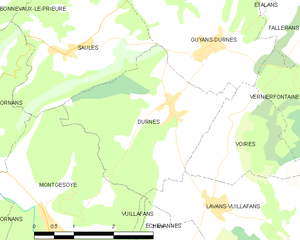
Durnes
- коммуна во Франции
Hiking in Durnes
Durness, located in the North Highlands of Scotland, is a fantastic destination for hiking enthusiasts. Its rugged coastline, dramatic landscapes, and abundant natural beauty offer a wide range of hiking opportunities suitable for various skill levels. Here are some highlights and considerations for hiking in and around Durness:...
- Страна:
- Почтовый код: 25580
- Координаты: 47° 6' 29" N, 6° 13' 53" E
- GPS треки (wikiloc): [Ссылка]
- Площадь: 8.51 кв.км
- Население: 171

Châteauvieux-les-Fossés
- коммуна во Франции
Hiking in Châteauvieux-les-Fossés
Châteauvieux-les-Fossés is a charming village located in the Drôme department in southeastern France. It is surrounded by beautiful natural landscapes that are perfect for hiking enthusiasts. Here are some key points about hiking in and around Châteauvieux-les-Fossés:...
- Страна:
- Почтовый код: 25840
- Координаты: 47° 3' 51" N, 6° 12' 7" E
- GPS треки (wikiloc): [Ссылка]
- Высота над уровнем моря: 431 м m
- Площадь: 4.46 кв.км
- Население: 12


Vuillafans
- коммуна во Франции
Hiking in Vuillafans
Vuillafans is a small commune located in the Doubs department in the Bourgogne-Franche-Comté region of eastern France. It is known for its picturesque landscapes, lush greenery, and charming rural atmosphere. Hiking in Vuillafans offers a fantastic opportunity to explore the natural beauty of the area....
- Страна:
- Почтовый код: 25840
- Координаты: 47° 3' 55" N, 6° 12' 59" E
- GPS треки (wikiloc): [Ссылка]
- Площадь: 6.14 кв.км
- Население: 727
- Веб сайт: [Ссылка]

Chantrans
- коммуна во Франции
Hiking in Chantrans
It seems there might be a slight misunderstanding, as "Chantrans" does not appear to be a well-known hiking destination or location as of my last update in October 2023. It could be a misspelling or a less-recognized area. If you meant a specific national park, region, or trail, please clarify the name or provide more context....
- Страна:
- Почтовый код: 25330
- Координаты: 47° 2' 36" N, 6° 9' 0" E
- GPS треки (wikiloc): [Ссылка]
- Площадь: 14.31 кв.км
- Население: 401

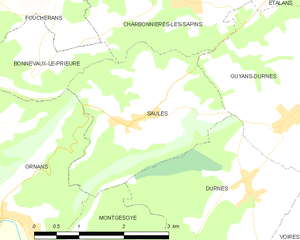
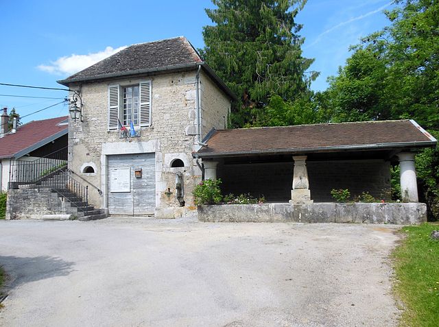
Saules
Hiking in Saules
Saules is a charming commune in the Doubs department of the Bourgogne-Franche-Comté region in eastern France. It is surrounded by stunning natural landscapes, making it a wonderful destination for hiking enthusiasts....
- Страна:
- Почтовый код: 25580
- Координаты: 47° 7' 24" N, 6° 11' 56" E
- GPS треки (wikiloc): [Ссылка]
- Площадь: 7.64 кв.км
- Население: 225