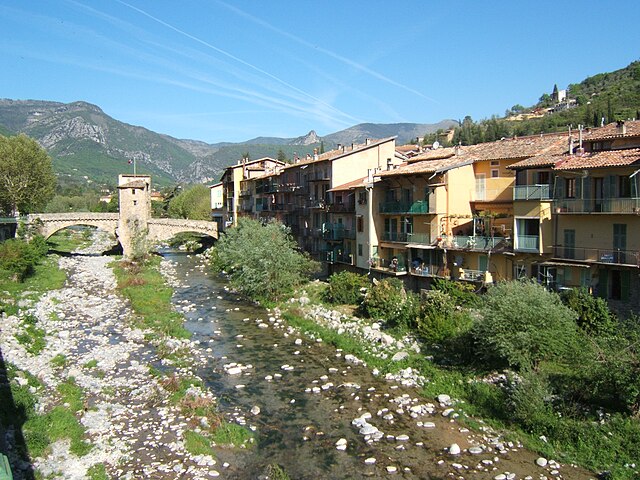
Мулине (Moulinet, Moulinet)
- коммуна в департаменте Приморские Альпы, регион Прованс — Альпы — Лазурный Берег, Франция
 Hiking in Мулине
Moulinet is a charming village located in the Alpes-Maritimes region of France, nestled in the foothills of the Alps and close to the stunning Mercantour National Park. The area is known for its beautiful landscapes, diverse flora and fauna, and numerous hiking trails suited for various skill levels. Here’s what you need to know about hiking in Moulinet:
Trails and Routes
-
GR52:
- The Grande Randonnée (GR) trail passes through the Moulinet area. The GR52 takes you along breathtaking alpine landscapes and offers stunning views of the surrounding mountains. This long-distance trail connects several picturesque villages in the region.
-
Local Trails:
- There are several well-marked local trails around Moulinet, suitable for both beginners and seasoned hikers. These trails often lead to scenic viewpoints or connect to nearby natural attractions.
-
Mercantour National Park:
- A short hike from Moulinet can take you into the Mercantour National Park, which is home to diverse wildlife and unique geological formations. Renowned for its stunning landscapes, you can find trails that range from easy walks to challenging ascents.
Hiking Tips
- Gear: Wear sturdy hiking boots and dress in layers, as the weather can change quickly in the mountains. Don’t forget to carry a good backpack with water, snacks, a map, and a first-aid kit.
- Best Season: The best time to hike in this area is typically spring to early fall (May to September). However, check local conditions, especially in higher elevations, as snow can linger late into the spring.
- Wildlife Spotting: Be on the lookout for local wildlife, including chamois, marmots, and a variety of bird species.
Local Attractions
- After your hike, take some time to explore the village of Moulinet itself, known for its historic architecture and quaint streets. You may also find local cuisine and culture to enrich your experience.
Safety
- Always inform someone about your hiking plans and expected return time. It’s advisable to check the weather forecast and trail conditions before setting out.
Conclusion
Hiking in Moulinet offers a blend of natural beauty, outdoor adventure, and cultural exploration. Whether you're a casual walker or an experienced hiker, you’ll find an array of trails that showcase the breathtaking landscapes of the Alpes-Maritimes region. Happy hiking!
- Страна:

- Почтовый код: 06380
- Координаты: 43° 56' 27" N, 7° 24' 46" E


- GPS треки (wikiloc): [Ссылка]
- Площадь: 41.07 кв.км
- Население: 274
- Википедия русская: wiki(ru)
- Википедия английская: wiki(en)
- Википедия национальная: wiki(fr)
- Хранилище Wikidata: Wikidata: Q649394
- Катеория в википедии: [Ссылка]
- код Freebase: [/m/03m4_9p]
- код Freebase: [/m/03m4_9p]
- код GeoNames: Альт: [6446722]
- код GeoNames: Альт: [6446722]
- номер SIREN: [210600862]
- номер SIREN: [210600862]
- код муниципалитета INSEE: 06086
- код муниципалитета INSEE: 06086
Граничит с регионами:


Брей-сюр-Руайя
- коммуна в департаменте Приморские Альпы, регион Прованс — Альпы — Лазурный Берег, Франция
Hiking in Брей-сюр-Руайя
Breil-sur-Roya, located in the Alpes-Maritimes department of France, is a charming village that serves as a gateway to some beautiful hiking trails in the surrounding area. Nestled in the Roya Valley, it offers a mix of stunning natural landscapes, historical sites, and a chance to experience the local culture....
- Страна:
- Почтовый код: 06540
- Координаты: 43° 56' 14" N, 7° 30' 52" E
- GPS треки (wikiloc): [Ссылка]
- Высота над уровнем моря: 287 м m
- Площадь: 81.31 кв.км
- Население: 2271
- Веб сайт: [Ссылка]


Ла-Боллен-Везюби
- коммуна в департаменте Приморские Альпы, регион Прованс — Альпы — Лазурный Берег, Франция
Hiking in Ла-Боллен-Везюби
La Bollène-Vésubie is a charming village located in the Alpes-Maritimes department in the Provence-Alpes-Côte d'Azur region of France. It offers access to beautiful hiking trails that showcase the stunning landscapes of the French Alps. Here are some highlights for hikers considering this area:...
- Страна:
- Почтовый код: 06450
- Координаты: 43° 59' 23" N, 7° 19' 51" E
- GPS треки (wikiloc): [Ссылка]
- Площадь: 35.57 кв.км
- Население: 567
- Веб сайт: [Ссылка]


Лантоск
- коммуна в департаменте Приморские Альпы, регион Прованс — Альпы — Лазурный Берег, Франция
Hiking in Лантоск
Lantosque is a charming commune located in the Alpes-Maritimes department in the Provence-Alpes-Côte d'Azur region of southeastern France. It offers a range of hiking opportunities set against the stunning backdrop of the French Alps and the nearby Mercantour National Park....
- Страна:
- Почтовый код: 06450
- Координаты: 43° 58' 24" N, 7° 18' 45" E
- GPS треки (wikiloc): [Ссылка]
- Площадь: 44.76 кв.км
- Население: 1314
- Веб сайт: [Ссылка]

Соспель
- коммуна в департаменте Приморские Альпы, регион Прованс — Альпы — Лазурный Берег, Франция
Hiking in Соспель
Sospel is a charming village located in the Alpes-Maritimes department of France, nestled in the scenic hills near the Italian border. It's an excellent base for hikers, offering a variety of trails that showcase the stunning natural beauty of the region. Here are some highlights of hiking in Sospel:...
- Страна:
- Почтовый код: 06380
- Координаты: 43° 52' 37" N, 7° 26' 54" E
- GPS треки (wikiloc): [Ссылка]
- Высота над уровнем моря: 348 м m
- Площадь: 62.39 кв.км
- Население: 3782
- Веб сайт: [Ссылка]


Люсерам
- коммуна в департаменте Приморские Альпы, регион Прованс — Альпы — Лазурный Берег, Франция
Hiking in Люсерам
Lucéram is a picturesque village located in the Alpes-Maritimes department of France, nestled in the hills of Provence near the French Riviera. The area surrounding Lucéram offers a variety of hiking opportunities, showcasing stunning landscapes, rich flora, and charming rural architecture....
- Страна:
- Почтовый код: 06440
- Координаты: 43° 52' 57" N, 7° 21' 38" E
- GPS треки (wikiloc): [Ссылка]
- Площадь: 65.52 кв.км
- Население: 1261