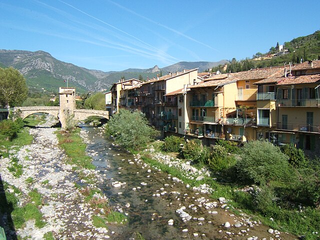
Брей-сюр-Руайя (Breil-sur-Roya, Breil-sur-Roya)

- коммуна в департаменте Приморские Альпы, регион Прованс — Альпы — Лазурный Берег, Франция
 Hiking in Брей-сюр-Руайя
Breil-sur-Roya, located in the Alpes-Maritimes department of France, is a charming village that serves as a gateway to some beautiful hiking trails in the surrounding area. Nestled in the Roya Valley, it offers a mix of stunning natural landscapes, historical sites, and a chance to experience the local culture.
Hiking Trails:
-
GR52 (Grande Randonnée 52): This long-distance trail runs through the Mercantour National Park and offers breathtaking views of the mountainous terrain. Sections of the trail can be accessed from Breil-sur-Roya.
-
Local Trails: There are numerous marked trails that cater to various skill levels. Some of the popular hikes include:
- Col de Tende: A moderate hike leading to stunning panoramic views of the surrounding valleys.
- Sentier des Gardes: A scenic route that allows hikers to immerse themselves in the local flora and fauna.
-
Wildlife Observation: The area is rich in biodiversity, making it a great spot for nature enthusiasts. Keep an eye out for various bird species and perhaps even wildlife like deer or chamois.
Preparation Tips:
- Gear: Ensure you have appropriate hiking gear, including sturdy boots, weather-appropriate clothing, and a good backpack.
- Hydration and Nutrition: Carry plenty of water and snacks to keep your energy up, especially on longer hikes.
- Maps and Guides: While many trails are marked, having a physical map or a reliable GPS can be beneficial.
Best Time to Hike:
The ideal time for hiking in Breil-sur-Roya is during the spring and fall when the temperatures are milder, and the landscape is particularly beautiful. Summer can be hot, while winter may present challenges with snow cover in higher elevations.
Accessibility:
Breil-sur-Roya is accessible by train or car, making it a convenient base for exploring the surrounding region. The village itself offers accommodations, ranging from hotels to guesthouses, so you can easily set up a base for your hiking adventures.
Cultural Opportunities:
Aside from hiking, take time to explore the village's narrow streets, local markets, and historical sites, enhancing your visit with cultural experiences.
In summary, Breil-sur-Roya is an excellent destination for hikers looking for diverse trails and stunning natural beauty, combined with the charm of a traditional French village.
- Страна:

- Почтовый код: 06540
- Координаты: 43° 56' 14" N, 7° 30' 52" E


- GPS треки (wikiloc): [Ссылка]
- Высота над уровнем моря: 287 м m
- Площадь: 81.31 кв.км
- Население: 2271
- Веб сайт: http://www.ville-breil-sur-roya.fr/index.php
- Википедия русская: wiki(ru)
- Википедия английская: wiki(en)
- Википедия национальная: wiki(fr)
- Хранилище Wikidata: Wikidata: Q321111
- Катеория в википедии: [Ссылка]
- код Freebase: [/m/02w94qp]
- код Freebase: [/m/02w94qp]
- код GeoNames: Альт: [3030387]
- код GeoNames: Альт: [3030387]
- номер SIREN: [210600235]
- номер SIREN: [210600235]
- код BNF: [11940289t]
- код BNF: [11940289t]
- код VIAF: Альт: [148904114]
- код VIAF: Альт: [148904114]
- код LCNAF: Альт: [n78064539]
- код LCNAF: Альт: [n78064539]
- код тезауруса PACTOLS: [pcrtOmRpFNshKr]
- код тезауруса PACTOLS: [pcrtOmRpFNshKr]
- WOEID: [22755809]
- WOEID: [22755809]
- код муниципалитета INSEE: 06023
- код муниципалитета INSEE: 06023
Граничит с регионами:


Айроле
- коммуна Италии
Hiking in Айроле
Airole is a charming village located in the Liguria region of Italy, near the border with France. It’s nestled in the picturesque valley of the Nervia River, surrounded by stunning landscapes that make it an attractive destination for hikers and nature enthusiasts. Here are some key points to consider when hiking in and around Airole:...
- Страна:

- Почтовый код: 18030
- Телефонный код: 0184
- Код автомобильного номера: IM
- Координаты: 43° 52' 19" N, 7° 33' 12" E
- GPS треки (wikiloc): [Ссылка]
- Высота над уровнем моря: 149 м m
- Площадь: 14.63 кв.км
- Население: 408
- Веб сайт: [Ссылка]


Дольчеаккуа
- коммуна Италии
Hiking in Дольчеаккуа
Dolceacqua is a charming village located in the Italian region of Liguria, near the border with France. It’s known for its picturesque medieval architecture, stunning landscapes, and the beautiful surrounding hills and valleys that offer a variety of hiking opportunities....
- Страна:
- Почтовый код: 18035
- Телефонный код: 0184
- Код автомобильного номера: IM
- Координаты: 43° 50' 53" N, 7° 37' 26" E
- GPS треки (wikiloc): [Ссылка]
- Высота над уровнем моря: 51 м m
- Площадь: 20.28 кв.км
- Население: 2093
- Веб сайт: [Ссылка]


Оливетта-Сан-Микеле
- коммуна Италии
Hiking in Оливетта-Сан-Микеле
Olivetta San Michele is a charming village located in the province of Imperia, in the Liguria region of Italy. Nestled in the beautiful Alps of Liguria, it offers stunning landscapes, rich natural beauty, and several hiking opportunities for outdoor enthusiasts....
- Страна:
- Почтовый код: 18030
- Телефонный код: 0184
- Код автомобильного номера: IM
- Координаты: 43° 52' 47" N, 7° 30' 56" E
- GPS треки (wikiloc): [Ссылка]
- Высота над уровнем моря: 292 м m
- Площадь: 13.84 кв.км
- Население: 214
- Веб сайт: [Ссылка]


Роккетта-Нервина
- коммуна Италии
Hiking in Роккетта-Нервина
Rocchetta Nervina is a charming village located in the Liguria region of Italy, specifically in the Province of Imperia. Nestled in the Nervia Valley and surrounded by stunning mountainous terrain, it serves as an excellent base for hiking enthusiasts looking to explore the natural beauty of the area....
- Страна:
- Почтовый код: 18030
- Телефонный код: 0184
- Код автомобильного номера: IM
- Координаты: 43° 53' 24" N, 7° 36' 1" E
- GPS треки (wikiloc): [Ссылка]
- Высота над уровнем моря: 235 м m
- Площадь: 15.29 кв.км
- Население: 299
- Веб сайт: [Ссылка]


Ла-Боллен-Везюби
- коммуна в департаменте Приморские Альпы, регион Прованс — Альпы — Лазурный Берег, Франция
Hiking in Ла-Боллен-Везюби
La Bollène-Vésubie is a charming village located in the Alpes-Maritimes department in the Provence-Alpes-Côte d'Azur region of France. It offers access to beautiful hiking trails that showcase the stunning landscapes of the French Alps. Here are some highlights for hikers considering this area:...
- Страна:
- Почтовый код: 06450
- Координаты: 43° 59' 23" N, 7° 19' 51" E
- GPS треки (wikiloc): [Ссылка]
- Площадь: 35.57 кв.км
- Население: 567
- Веб сайт: [Ссылка]

Соспель
- коммуна в департаменте Приморские Альпы, регион Прованс — Альпы — Лазурный Берег, Франция
Hiking in Соспель
Sospel is a charming village located in the Alpes-Maritimes department of France, nestled in the scenic hills near the Italian border. It's an excellent base for hikers, offering a variety of trails that showcase the stunning natural beauty of the region. Here are some highlights of hiking in Sospel:...
- Страна:
- Почтовый код: 06380
- Координаты: 43° 52' 37" N, 7° 26' 54" E
- GPS треки (wikiloc): [Ссылка]
- Высота над уровнем моря: 348 м m
- Площадь: 62.39 кв.км
- Население: 3782
- Веб сайт: [Ссылка]

Мулине
- коммуна в департаменте Приморские Альпы, регион Прованс — Альпы — Лазурный Берег, Франция
Hiking in Мулине
Moulinet is a charming village located in the Alpes-Maritimes region of France, nestled in the foothills of the Alps and close to the stunning Mercantour National Park. The area is known for its beautiful landscapes, diverse flora and fauna, and numerous hiking trails suited for various skill levels. Here’s what you need to know about hiking in Moulinet:...
- Страна:
- Почтовый код: 06380
- Координаты: 43° 56' 27" N, 7° 24' 46" E
- GPS треки (wikiloc): [Ссылка]
- Площадь: 41.07 кв.км
- Население: 274
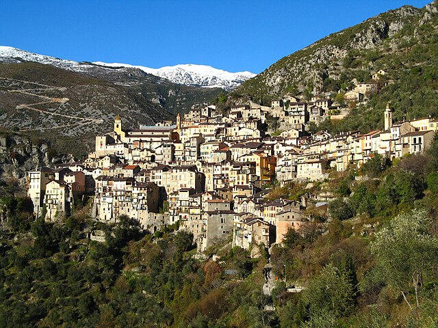

Саорж
- коммуна в департаменте Приморские Альпы, регион Прованс — Альпы — Лазурный Берег, Франция
Hiking in Саорж
Saorge is a picturesque village located in the Alpes-Maritimes region of France, not far from the Italian border. The area is known for its stunning landscapes, charming architecture, and an array of hiking opportunities that cater to different skill levels. Here are some highlights and trails to consider when hiking in and around Saorge:...
- Страна:
- Почтовый код: 06540
- Координаты: 43° 59' 14" N, 7° 33' 9" E
- GPS треки (wikiloc): [Ссылка]
- Высота над уровнем моря: 513 м m
- Площадь: 86.78 кв.км
- Население: 455
- Веб сайт: [Ссылка]