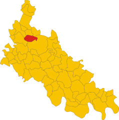
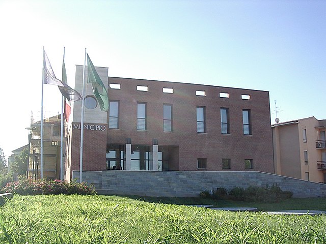
Мулаццано (Mulazzano, Mulazzano)
.svg)
- коммуна Италии
 Hiking in Мулаццано
Mulazzano is a small town located in the Lombardy region of Italy, not far from Milan. While its specific hiking trails may not be as famous as those found in more mountainous areas, there are still opportunities for outdoor enthusiasts to enjoy the natural beauty of the surrounding countryside.
Hiking Highlights in Mulazzano
-
Nearby Natural Parks: While Mulazzano itself may not have dedicated hiking trails, it's close to several natural reserves and parks that can be explored. The nearby Parco Agricolo Sud Milano provides vast landscapes with rural paths ideal for hiking, cycling, and enjoying nature.
-
Rural Trails: The region features numerous unpaved roads and paths that wind through the countryside. These trails often lead hikers through picturesque villages, vineyards, and agricultural land, providing a glimpse into the local way of life.
-
Proximity to the Adda River: The Adda River, located a short drive from Mulazzano, offers beautiful landscapes and well-marked walking paths along its banks. This can be a great destination for a day hike where you can enjoy the river’s scenic beauty.
-
Historical Sites: Many hikes can be combined with visits to historical sites in the area. Keep an eye out for old churches, farmhouses, and other local landmarks as you trek through the landscape.
-
Tips for Hiking:
- Trail Maps: Check for local hiking maps or apps that provide details on trail difficulty and terrain.
- Prepare for the Weather: The weather can vary, so dress in layers and bring rain gear if needed.
- Local Guidance: If you’re unfamiliar with the area, consider joining a local hiking group or hiring a guide who knows the best routes.
- Stay Hydrated: Always carry enough water, especially on longer hikes.
Conclusion
While Mulazzano may not be a renowned hiking destination, its proximity to nature and charming rural landscapes provides ample opportunity for outdoor explorations. Enjoy your hiking experience, and remember to respect nature and local regulations!
- Страна:

- Почтовый код: 26837
- Телефонный код: 02
- Код автомобильного номера: LO
- Координаты: 45° 22' 21" N, 9° 23' 52" E


- GPS треки (wikiloc): [Ссылка]
- Высота над уровнем моря: 91 м m
- Площадь: 15.58 кв.км
- Население: 5773
- Веб сайт: http://www.comune.mulazzano.lo.it/
- Википедия русская: wiki(ru)
- Википедия английская: wiki(en)
- Википедия национальная: wiki(it)
- Хранилище Wikidata: Wikidata: Q42249
- Катеория в википедии: [Ссылка]
- код Freebase: [/m/0gr5z6]
- код GeoNames: Альт: [6543691]
- ID отношения в OpenStreetMap: [44778]
- UN/LOCODE: [ITMUZ]
- код ISTAT: 098041
- кадастровый код Италии: F801
Граничит с регионами:

Монтаназо-Лобмардо
- коммуна Италии
Hiking in Монтаназо-Лобмардо
Montanaso Lombardo, a small municipality in Italy located in the Lombardy region, is not typically known as a prime hiking destination compared to the more famous nearby areas like the Italian Alps or the Apennines. However, it can serve as a good base for exploring the surrounding countryside....
- Страна:
- Почтовый код: 26836
- Телефонный код: 0371
- Код автомобильного номера: LO
- Координаты: 45° 20' 12" N, 9° 28' 11" E
- GPS треки (wikiloc): [Ссылка]
- Высота над уровнем моря: 83 м m
- Площадь: 9.52 кв.км
- Население: 2271
- Веб сайт: [Ссылка]


Червиньяно-д'Адда
- коммуна Италии
Hiking in Червиньяно-д'Адда
Cervignano d'Adda, situated in the Lombardy region of Italy, offers a unique blend of natural beauty and cultural heritage, making it an interesting destination for hikers. While it may not be as widely known as some of the larger national parks in Italy, there are several trails and outdoor activities to explore in the surrounding area....
- Страна:
- Почтовый код: 26832
- Телефонный код: 02
- Код автомобильного номера: LO
- Координаты: 45° 18' 0" N, 9° 35' 0" E
- GPS треки (wikiloc): [Ссылка]
- Высота над уровнем моря: 87 м m
- Площадь: 4.07 кв.км
- Население: 2209
- Веб сайт: [Ссылка]

Дрезано
- коммуна Италии
Hiking in Дрезано
Dresano is a small town located near Milan in Italy. While it may not be universally known for extensive hiking trails, the surrounding areas offer opportunities for outdoor enthusiasts to explore. Here are some insights into hiking in and around Dresano:...
- Страна:
- Почтовый код: 20070
- Телефонный код: 02
- Код автомобильного номера: MI
- Координаты: 45° 22' 0" N, 9° 22' 0" E
- GPS треки (wikiloc): [Ссылка]
- Высота над уровнем моря: 91 м m
- Площадь: 3.48 кв.км
- Население: 3036
- Веб сайт: [Ссылка]
Трибьано
- коммуна Италии
Hiking in Трибьано
Tribiano is a small town located in the Lombardy region of Italy, not far from Milan. While it may not be a well-known destination for hiking, its proximity to the surrounding areas offers some opportunities for outdoor activities. Here are some insights into hiking in and around Tribiano:...
- Страна:
- Почтовый код: 20067
- Телефонный код: 02
- Код автомобильного номера: MI
- Координаты: 45° 25' 0" N, 9° 23' 0" E
- GPS треки (wikiloc): [Ссылка]
- Высота над уровнем моря: 93 м m
- Площадь: 7 кв.км
- Население: 3545
- Веб сайт: [Ссылка]


Паулло
- коммуна Италии
Hiking in Паулло
Paullo, located in the Metropolitan City of Milan, Italy, offers various opportunities for hiking enthusiasts, especially for those looking to escape the busy urban environment. While Paullo itself may not have extensive hiking trails, it serves as a good starting point for accessing nearby natural areas and parks that provide beautiful landscapes and outdoor experiences....
- Страна:
- Почтовый код: 20067
- Телефонный код: 02
- Код автомобильного номера: MI
- Координаты: 45° 25' 0" N, 9° 24' 0" E
- GPS треки (wikiloc): [Ссылка]
- Высота над уровнем моря: 97 м m
- Площадь: 8.82 кв.км
- Население: 11461
- Веб сайт: [Ссылка]
Гальганьяно
- коммуна Италии
Hiking in Гальганьяно
Galgagnano is a small village located in the northern Italian region of Lombardy, known for its tranquil countryside and beautiful landscapes. While it may not be a highly popular hiking destination compared to some mountainous regions in Italy, it offers opportunities for nature walks and hikes through the surrounding countryside....
- Страна:
- Почтовый код: 26832
- Телефонный код: 0371
- Код автомобильного номера: LO
- Координаты: 45° 21' 32" N, 9° 26' 47" E
- GPS треки (wikiloc): [Ссылка]
- Высота над уровнем моря: 86 м m
- Площадь: 6.01 кв.км
- Население: 1263
- Веб сайт: [Ссылка]


Таваццано-кон-Виллавеско
- коммуна Италии
Hiking in Таваццано-кон-Виллавеско
Tavazzano con Villavesco is a charming municipality located in the Lombardy region of Italy, specifically in the province of Lodi. While it may not be widely known as a hiking destination, it offers some opportunities for outdoor activities and enjoying nature in a relatively tranquil setting....
- Страна:
- Почтовый код: 26838
- Телефонный код: 0371
- Код автомобильного номера: LO
- Координаты: 45° 19' 42" N, 9° 24' 27" E
- GPS треки (wikiloc): [Ссылка]
- Высота над уровнем моря: 82 м m
- Площадь: 16.07 кв.км
- Население: 6012
- Веб сайт: [Ссылка]


Зело-Буон-Персико
- коммуна Италии
Hiking in Зело-Буон-Персико
Zelo Buon Persico, a small town in the Lombardy region of Italy, is situated near the larger city of Lodi and is known for its natural surroundings, which offer opportunities for outdoor activities, including hiking. Although Zelo Buon Persico itself may not have an extensive network of hiking trails, the surrounding area features beautiful landscapes that are suitable for leisurely hikes....
- Страна:
- Почтовый код: 26839
- Телефонный код: 02
- Код автомобильного номера: LO
- Координаты: 45° 24' 48" N, 9° 26' 1" E
- GPS треки (wikiloc): [Ссылка]
- Высота над уровнем моря: 90 м m
- Площадь: 18.88 кв.км
- Население: 7373
- Веб сайт: [Ссылка]


Казальмайокко
- коммуна Италии
Hiking in Казальмайокко
Casalmaiocco is a small town in the Lombardy region of Italy, situated in the province of Lodi. While it may not be widely recognized for extensive hiking trails, the surrounding area offers opportunities for outdoor activities, including hiking and nature walks....
- Страна:
- Почтовый код: 26831
- Телефонный код: 02
- Код автомобильного номера: LO
- Координаты: 45° 21' 17" N, 9° 22' 31" E
- GPS треки (wikiloc): [Ссылка]
- Высота над уровнем моря: 88 м m
- Площадь: 4.71 кв.км
- Население: 3190
- Веб сайт: [Ссылка]