
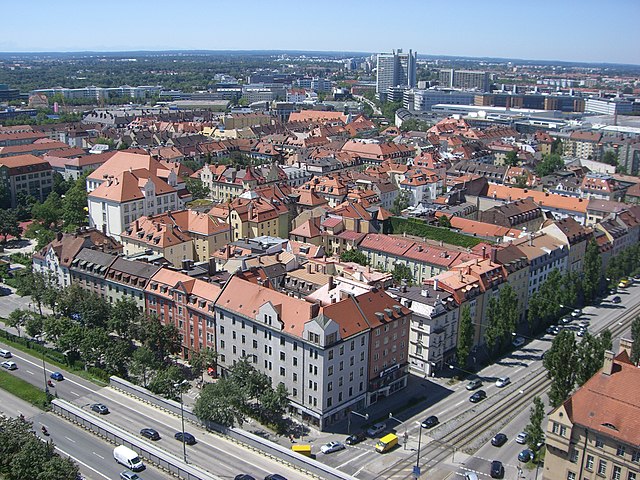
Мюнхен (Munich, München)
.svg)
.svg)
- город в Германии, столица Баварии
 Hiking in Мюнхен
Hiking in Munich offers a fantastic blend of urban and natural experiences. Munich is the capital of Bavaria, situated close to the Alps, which makes it an excellent base for various hikes. Here’s an overview of hiking in and around Munich:
Local Hiking Options
-
Isar River Trails:
- The banks of the Isar River offer lovely flat trails perfect for hiking or leisurely walks. You can enjoy the natural scenery and picnic spots along the way.
-
Englischer Garten:
- One of the largest urban parks in the world, the Englischer Garten features winding paths, wooded areas, and serene spots near the river. It’s ideal for casual walks and exploring nature without leaving the city.
-
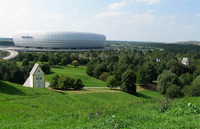
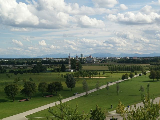
Olympic Park:
- The park, built for the 1972 Olympics, has several trails with picturesque views, especially from the hilltop where the Olympic Tower stands. It's a great place for walking and enjoying the architecture and landscape.
Day Hikes Nearby
-
Tegernsee:
- About an hour’s drive from Munich, Tegernsee offers stunning views and challenging hikes. Trails range from easy lakeside walks to more strenuous mountain routes.
-
Garmisch-Partenkirchen:
- Known for its breathtaking mountain scenery, Garmisch-Partenkirchen is just a couple of hours away. You can hike up to the Zugspitze, Germany's highest peak, or take on other trails like the Partnach Gorge.
-
Ammer Mountains (Ammergebirge):
- Located southwest of Munich, this area offers diverse hiking options, from lake walks at Lake Staffelsee to challenging mountain hikes, such as the tour to the Kofel Mountain.
Hiking Tips
-
Check Weather Conditions: Always check the weather forecast before heading out, especially in mountain areas where conditions can change rapidly.
-
Trail Maps and Guides: Consider bringing a map or a hiking GPS. While many trails are well-marked, having a guide can enhance your experience.
-
Appropriate Gear: Wear sturdy hiking boots and dress in layers, as temperatures can fluctuate. Also, don't forget essentials like water, snacks, and a first-aid kit.
-
Respect Nature: Follow the Leave No Trace principles—pack out what you bring in and respect local wildlife.
-
Public Transportation: Munich has excellent public transportation options. Many trails can be accessed via trains or buses, making it convenient to embark on hiking adventures without needing a car.
With its lush parks, scenic trails, and proximity to the Bavarian Alps, hiking in and around Munich provides options for everyone from casual walkers to seasoned hikers. Enjoy your outdoor explorations!
- Страна:

- Почтовый код: 81825; 81735; 81730; 81737; 81379; 81377; 80805; 80802; 81929; 80331
- Телефонный код: 089
- Код автомобильного номера: M
- Координаты: 48° 8' 14" N, 11° 34' 32" E


- GPS треки (wikiloc): [Ссылка]
- Высота над уровнем моря: 519 м m
- Площадь: 310.71 кв.км
- Население: 1456039
- Веб сайт: http://www.muenchen.de/
- Википедия русская: wiki(ru)
- Википедия английская: wiki(en)
- Википедия национальная: wiki(de)
- Хранилище Wikidata: Wikidata: Q1726
- Галерея изображений в википедии: [Ссылка]
- Катеория в википедии: [Ссылка]
- Карты в википедии: [Ссылка]
- код Freebase: [/m/02h6_6p]
- код GeoNames: Альт: [2867714]
- код BNF: [11864901q]
- код VIAF: Альт: [154701792]
- ID отношения в OpenStreetMap: [62428]
- код GND: Альт: [4127793-4]
- идентификатор местоположения ArchINFORM: [258]
- код LCNAF: Альт: [n79059670]
- место в MusicBrainz: [89bbbab6-72de-43eb-81ba-e620ab207008]
- WOEID: [676757]
- код темы Quora: [Munich-Germany]
- код TGN: [7004333]
- UN/LOCODE: [DEMUC]
- код SUDOC: [026392933]
- код в энциклопедии «Британника онлайн»: [place/Munich-Bavaria-Germany]
- код в Encyclopædia Universalis: [munich]
- идентификатор HDS: [6600]
- EMLO location ID: [b82db615-6917-4296-bb58-f6afca279bc5]
- код места в Facebook: [116045151742857]
- учётная запись в Твиттере: Альт: [muenchen_de]
- код в Большой российской энциклопедии онлайн: [2242207]
- Bavarikon ID: [ODB_A00000904]
- код ISNI: Альт: [0000 0001 2189 3141]
- код NKC: [ge130044]
- dmoz: Альт: [Regional/Europe/Germany/States/Bavaria/Localities/Munich/]
- код NLI: [000971441]
- код канала YouTube: [UCUpmzhtRAiRYDUmpshbt9wA]
- код NUTS: [DE212]
- код YSO: [165678]
- Nomisma ID: [munich]
- код статьи Klexikon: [München]
- код BabelNet: [00056219n]
- сабреддит: [munich]
- учётная запись Facebook: Альт: [muenchen]
- FAST ID: [1205308]
- код NDL: [00629311]
- Store norske leksikon ID: [München]
- учётная запись Google+: [110857161346153584395]
- справка РИА Новости: [54721131]
- учётная запись Pinterest: [muenchen]
- идентификатор муниципалитетов в Германии: 09162000
- код US National Archives: 10044897
- код района Германии: 09162
Включает регионы:

Schwanthalerhöhe
Hiking in Schwanthalerhöhe
Schwanthalerhöhe is a district in Munich, Germany, known for its urban setting and proximity to various parks and green spaces rather than traditional hiking trails. However, if you're looking to enjoy nature and the outdoors in this area, there are several options available:...
- Страна:
- Почтовый код: 80335; 80339
- Телефонный код: 089
- Координаты: 48° 8' 20" N, 11° 32' 30" E
- GPS треки (wikiloc): [Ссылка]
- Площадь: 2.0702 кв.км
- Население: 30282
- Веб сайт: [Ссылка]
Sendling-Westpark
Hiking in Sendling-Westpark
Sendling-Westpark is a district situated in the southwest of Munich, Germany, offering a variety of outdoor experiences, though it may not be primarily known for traditional hiking trails like those found in mountainous areas. However, it does provide several opportunities for leisurely walks and nature exploration....
- Страна:
- Почтовый код: 81373; 81369; 80686
- Телефонный код: 089
- Координаты: 48° 7' 20" N, 11° 31' 55" E
- GPS треки (wikiloc): [Ссылка]
- Площадь: 7.80 кв.км
- Население: 59175
- Веб сайт: [Ссылка]


Milbertshofen-Am Hart
Hiking in Milbertshofen-Am Hart
Milbertshofen-Am Hart is a district in Munich, Germany, situated near the northern outskirts of the city. While it may not be directly known for extensive hiking trails, it offers some opportunities for outdoor activities, including hiking and walking paths....
- Страна:
- Почтовый код: 80939; 80937; 80809; 80807
- Телефонный код: 089
- Координаты: 48° 11' 54" N, 11° 34' 35" E
- GPS треки (wikiloc): [Ссылка]
- Высота над уровнем моря: 519 м m
- Площадь: 13.42 кв.км
- Население: 76647
Au-Haidhausen
Hiking in Au-Haidhausen
Au-Haidhausen is a district in Munich, Germany. While it is primarily an urban area known for its scenic streets, cafes, and cultural sites, it is not typically recognized for hiking in the traditional sense. However, there are plenty of opportunities for walking and exploring both in the district and nearby....
- Страна:
- Почтовый код: 81669; 81667; 81543; 81541
- Телефонный код: 089
- Координаты: 48° 7' 55" N, 11° 35' 20" E
- GPS треки (wikiloc): [Ссылка]
- Площадь: 4.24 кв.км
- Население: 61699
Фельдмохинг-Хазенбергль
- район Мюнхена
Hiking in Фельдмохинг-Хазенбергль
Feldmoching-Hasenbergl, located in the northern part of Munich, offers a unique opportunity for hikers to explore a mix of urban nature areas and more rural landscapes. Here are some key points about hiking in the area:...
- Страна:
- Почтовый код: 80995; 80935; 80933
- Телефонный код: 089
- Координаты: 48° 12' 40" N, 11° 32' 30" E
- GPS треки (wikiloc): [Ссылка]
- Площадь: 28.9378 кв.км
- Население: 61764
Allach-Untermenzing
Hiking in Allach-Untermenzing
Allach-Untermenzing is a neighborhood in the northwest of Munich, Germany, and while it is primarily urban, it offers access to some beautiful natural areas suitable for hiking and outdoor activities....
- Страна:
- Почтовый код: 80999; 80997; 80995
- Телефонный код: 089
- Координаты: 48° 12' 0" N, 11° 27' 10" E
- GPS треки (wikiloc): [Ссылка]
- Площадь: 15.38 кв.км
- Население: 32705

Schwabing-Freimann
Hiking in Schwabing-Freimann
Schwabing-Freimann is a district in Munich, Germany, known more for its urban atmosphere than for traditional hiking trails. However, there are several options for nature walks and recreational activities in and around the area. Here are some highlights:...
- Страна:
- Почтовый код: 80803; 80802; 80801; 80538
- Телефонный код: 089
- Координаты: 48° 10' 50" N, 11° 36' 10" E
- GPS треки (wikiloc): [Ссылка]
- Площадь: 25.6722 кв.км
- Население: 77626
Schwabing-West
Hiking in Schwabing-West
Schwabing-West is a vibrant neighborhood in Munich, Germany, known more for its urban atmosphere, cultural offerings, and parks rather than extensive hiking trails. However, there are opportunities for outdoor activities and nature walks in and around this area....
- Страна:
- Почтовый код: 80799; 80798; 80797; 80796
- Телефонный код: 089
- Координаты: 48° 9' 40" N, 11° 34' 8" E
- GPS треки (wikiloc): [Ссылка]
- Площадь: 4.34 кв.км
- Население: 69407
Обергизинг-Фасангартен
Hiking in Обергизинг-Фасангартен
Obergiesing is a district in Munich, Germany, and while it isn't known for traditional hiking trails like those found in rural mountains, there are plenty of opportunities for walking, exploring urban parks, and enjoying green spaces in and around the area....
- Страна:
- Почтовый код: 81541; 81539
- Телефонный код: 089
- Координаты: 48° 6' 40" N, 11° 35' 40" E
- GPS треки (wikiloc): [Ссылка]
- Площадь: 5.72 кв.км
- Население: 54784
Ramersdorf-Perlach
Hiking in Ramersdorf-Perlach
Ramersdorf-Perlach is a district in the southeastern part of Munich, Germany. While it's primarily known for its urban environment, there are several opportunities for hiking and enjoying nature within and around the area....
- Страна:
- Почтовый код: 81671; 81669; 81549; 81539
- Телефонный код: 089
- Координаты: 48° 6' 10" N, 11° 37' 30" E
- GPS треки (wikiloc): [Ссылка]
- Площадь: 19.88 кв.км
- Население: 114708
Pasing-Obermenzing
Hiking in Pasing-Obermenzing
Pasing-Obermenzing is a district in the western part of Munich, Germany. While it may not be known as a prime hiking destination compared to some of the more rural or mountainous areas in Germany, there are still plenty of outdoor opportunities for walking and light hiking enthusiasts....
- Страна:
- Почтовый код: 81247; 81245; 81243; 81241; 80689; 80687
- Телефонный код: 089
- Координаты: 48° 8' 45" N, 11° 27' 35" E
- GPS треки (wikiloc): [Ссылка]
- Площадь: 16.5 кв.км
- Население: 74645


Maxvorstadt
Hiking in Maxvorstadt
Maxvorstadt is a vibrant district in Munich, Germany, known for its cultural attractions, museums, and university vibe. While it may not offer traditional hiking trails like you'd find in more rural or mountainous areas, there are still plenty of outdoor opportunities and scenic walking routes. Here are some suggestions for enjoying the great outdoors in or around Maxvorstadt:...
- Страна:
- Почтовый код: 80797; 80636; 80539; 80335; 80333
- Телефонный код: 089
- Координаты: 48° 9' 0" N, 11° 34' 10" E
- GPS треки (wikiloc): [Ссылка]
- Площадь: 4.3 кв.км
- Население: 53443
- Веб сайт: [Ссылка]


Laim
Hiking in Laim
Laim is a district in Munich, Germany, and while it may not be known for extensive hiking trails like some more rural areas, it does provide access to various walking and cycling paths and is close to several parks and natural spaces....
- Страна:
- Почтовый код: 80689; 80687; 80686
- Телефонный код: 089
- Координаты: 48° 8' 25" N, 11° 29' 50" E
- GPS треки (wikiloc): [Ссылка]
- Площадь: 5.28 кв.км
- Население: 56335
- Веб сайт: [Ссылка]


Sendling
Hiking in Sendling
Sendling is a vibrant district located in the southwestern part of Munich, Germany. While Sendling itself is primarily an urban area, it acts as a good starting point for various hiking excursions in the surrounding regions. Here’s what you can expect when hiking near Sendling:...
- Страна:
- Почтовый код: 81369; 80469; 80337; 80336
- Телефонный код: 089
- Координаты: 48° 7' 17" N, 11° 32' 29" E
- GPS треки (wikiloc): [Ссылка]
- Площадь: 3.9387 кв.км
- Население: 41230
- Веб сайт: [Ссылка]
Moosach
Hiking in Moosach
Moosach is a district in Munich, Germany, known for its urban atmosphere and residential areas. While it may not be a traditional hiking destination, there are several nearby parks and green spaces that offer excellent opportunities for walking and light hiking. Here are some options:...
- Страна:
- Почтовый код: 80638; 80637
- Телефонный код: 089
- Координаты: 48° 11' 0" N, 11° 31' 0" E
- GPS треки (wikiloc): [Ссылка]
- Площадь: 11.10 кв.км
- Население: 54045


Untergiesing-Harlaching
Hiking in Untergiesing-Harlaching
Untergiesing-Harlaching is a district located in the southern part of Munich, Germany. While it might not be known for extensive hiking trails like some of the more rural areas around Munich, it does offer some pleasant walking and hiking opportunities, especially along the banks of the Isar River....
- Страна:
- Почтовый код: 81547; 81545; 81543
- Телефонный код: 089
- Координаты: 48° 5' 32" N, 11° 33' 38" E
- GPS треки (wikiloc): [Ссылка]
- Площадь: 8.06 кв.км
- Население: 54050


Нойхаузен-Нимфенбург
- район Мюнхена
Hiking in Нойхаузен-Нимфенбург
Neuhausen-Nymphenburg is a delightful area in Munich, Germany, known for its beautiful parks, scenic trails, and rich cultural heritage, making it a lovely choice for hiking and outdoor activities....
- Страна:
- Почтовый код: 80637; 80636; 80639; 80638; 80634
- Телефонный код: 089
- Координаты: 48° 9' 25" N, 11° 31' 0" E
- GPS треки (wikiloc): [Ссылка]
- Площадь: 12.93 кв.км
- Население: 99821
Хадерн
Hiking in Хадерн
Hadern is a district located in Munich, Germany, and while it may not be known as a premier hiking destination, it does offer some opportunities for outdoor activities and walks in natural settings. If you’re looking for hiking experiences in and around Hadern, here are some things to consider:...
- Страна:
- Почтовый код: 81377; 81375; 80689
- Телефонный код: 089
- Координаты: 48° 6' 38" N, 11° 27' 55" E
- GPS треки (wikiloc): [Ссылка]
- Площадь: 9.22 кв.км
- Население: 50567
- Веб сайт: [Ссылка]
Bogenhausen
Hiking in Bogenhausen
Bogenhausen is a district in Munich, Germany, known for its residential areas and green spaces. While Bogenhausen itself may not be a traditional hiking destination with rugged trails, it offers access to nearby parks and areas that are great for walking and light hiking....
- Страна:
- Почтовый код: 81679; 81677; 81675
- Телефонный код: 089
- Координаты: 48° 8' 53" N, 11° 37' 0" E
- GPS треки (wikiloc): [Ссылка]
- Площадь: 23.69 кв.км
- Население: 87164
Талькирхен-Оберзендлинг-Форстенрид-Фюрстенрид-Зольн
Hiking in Талькирхен-Оберзендлинг-Форстенрид-Фюрстенрид-Зольн
Thalkirchen, Obersendling, Forstenried, Fürstenried, and Solln are neighborhoods in the southern part of Munich, Germany, and while these areas are primarily urban, they also provide access to beautiful parks, green spaces, and some trails for hiking and walking....
- Страна:
- Почтовый код: 81476; 81475; 81379
- Телефонный код: 089
- Координаты: 48° 5' 20" N, 11° 31' 10" E
- GPS треки (wikiloc): [Ссылка]
- Площадь: 17.77 кв.км
- Население: 96199
Berg am Laim
Hiking in Berg am Laim
Berg am Laim is a district in Munich, Germany, which isn't traditionally known as a hiking destination; however, it does offer some opportunities for outdoor activities and walking. While the area itself is more urban, you can enjoy pleasant walks and explore some parks....
- Страна:
- Почтовый код: 81825; 81735; 81673; 81671
- Телефонный код: 089
- Координаты: 48° 7' 20" N, 11° 37' 40" E
- GPS треки (wikiloc): [Ссылка]
- Площадь: 6.3146 кв.км
- Население: 45655
- Веб сайт: [Ссылка]


Aubing-Lochhausen-Langwied
Hiking in Aubing-Lochhausen-Langwied
Aubing-Lochhausen-Langwied is a district in the western part of Munich, Germany. While it is primarily an urban area, there are still opportunities for hiking and enjoying the natural surroundings....
- Страна:
- Почтовый код: 81249; 81245; 81243
- Телефонный код: 089
- Координаты: 48° 9' 30" N, 11° 25' 10" E
- GPS треки (wikiloc): [Ссылка]
- Высота над уровнем моря: 519 м m
- Площадь: 3.42 кв.км
- Население: 46468


Ludwigsvorstadt-Isarvorstadt
Hiking in Ludwigsvorstadt-Isarvorstadt
Ludwigsvorstadt-Isarvorstadt is a vibrant district located in Munich, Germany. While it's not primarily known for hiking in the traditional sense—since it is more urban and densely populated than natural landscapes—it does offer various walking and outdoor opportunities. Here are some highlights if you're considering outdoor activities in the area:...
- Страна:
- Почтовый код: 80469; 80337; 80336; 80335
- Телефонный код: 089
- Координаты: 48° 7' 38" N, 11° 33' 53" E
- GPS треки (wikiloc): [Ссылка]
- Высота над уровнем моря: 519 м m
- Площадь: 4.4014 кв.км
- Население: 54915

Trudering-Riem
Hiking in Trudering-Riem
Trudering-Riem, located in the eastern part of Munich, Germany, may not be the most prominent hiking destination compared to larger national parks or mountain regions, but it does offer some pleasant opportunities for outdoor activities, including hiking....
- Страна:
- Почтовый код: 81825; 81829; 81827; 81735
- Телефонный код: 089
- Координаты: 48° 7' 0" N, 11° 39' 30" E
- GPS треки (wikiloc): [Ссылка]
- Площадь: 22.45 кв.км
- Население: 72182
Альтштадт-Леэль
Hiking in Альтштадт-Леэль
Altstadt-Lehel is a neighborhood in Munich, Germany, known for its historic architecture, cultural landmarks, and proximity to natural green spaces. While it's primarily an urban area, there are some great opportunities for hiking and nature walks in and around the region....
- Страна:
- Почтовый код: 80336; 80335; 80333; 80331
- Телефонный код: 089
- Координаты: 48° 8' 10" N, 11° 34' 20" E
- GPS треки (wikiloc): [Ссылка]
- Площадь: 3.14 кв.км
- Население: 21454
Граничит с регионами:

Дахау
Hiking in Дахау
Dachau, located just north of Munich in Bavaria, Germany, is a region rich in history and natural beauty, making it a great destination for hiking. Here are some highlights about hiking in the Dachau district:...
- Страна:
- Столица: Дахау
- Код автомобильного номера: DAH
- Координаты: 48° 15' 0" N, 11° 25' 12" E
- GPS треки (wikiloc): [Ссылка]
- Высота над уровнем моря: 506 м m
- Площадь: 579.00 кв.км
- Население: 152703
- Веб сайт: [Ссылка]


Фюрстенфельдбрук
Hiking in Фюрстенфельдбрук
Fürstenfeldbruck is a beautiful district located just outside of Munich, Germany, and offers a variety of scenic hiking opportunities. The region is characterized by its rolling hills, lush forests, and picturesque landscapes, making it a great destination for hikers of all skill levels....
- Страна:
- Столица: Фюрстенфельдбрук
- Код автомобильного номера: FFB
- Координаты: 48° 10' 12" N, 11° 10' 12" E
- GPS треки (wikiloc): [Ссылка]
- Высота над уровнем моря: 550 м m
- Площадь: 435.00 кв.км
- Население: 172760
- Веб сайт: [Ссылка]

Мюнхен
- район Баварии
Hiking in Мюнхен
Hiking in and around Munich, the capital of Bavaria, offers a wonderful blend of urban landscapes and stunning natural scenery. While Munich itself is a vibrant city with parks and green spaces, many hiking opportunities are just a short distance away in the surrounding region....
- Страна:
- Столица: Мюнхен
- Телефонный код: 089
- Код автомобильного номера: WOR; M; AIB
- Координаты: 48° 0' 0" N, 11° 40' 12" E
- GPS треки (wikiloc): [Ссылка]
- Высота над уровнем моря: 513 м m
- Площадь: 52020.58 кв.км
- Население: 343405
- Веб сайт: [Ссылка]

Гархинг-бай-Мюнхен
- город в Баварии
Hiking in Гархинг-бай-Мюнхен
Garching bei München is primarily known as a residential and research community located just north of Munich, Germany. Although Garching itself is not renowned for extensive hiking trails, it does provide access to several nearby outdoor opportunities and nature areas. Here are some suggestions for hiking and outdoor activities in and around Garching:...
- Страна:
- Почтовый код: 85748
- Телефонный код: 089
- Код автомобильного номера: M
- Координаты: 48° 15' 0" N, 11° 39' 0" E
- GPS треки (wikiloc): [Ссылка]
- Высота над уровнем моря: 482 м m
- Площадь: 28.16 кв.км
- Население: 11587
- Веб сайт: [Ссылка]