
Верхняя Бавария (Upper Bavaria, Oberbayern)


- административный округ в земле Бавария, Германия
 Hiking in Верхняя Бавария
Upper Bavaria is a beautiful region in southern Germany, known for its stunning landscapes, charming villages, and a wealth of outdoor activities, particularly hiking. Here are some highlights and tips for hiking in Upper Bavaria:
Landscapes and Scenery
-
Alpine Peaks: The region is home to some of the Bavarian Alps' most impressive mountains, including the Zugspitze, Germany's highest peak. The jagged peaks and scenic vistas offer breathtaking views.
-
Lakes and Valleys: Upper Bavaria boasts picturesque lakes such as the Starnberger See and the Ammersee, perfect for a post-hike dip or picnic. The valleys, such as the Tegernsee Valley, provide lush meadows and wooded areas.
-
Forests and Nature Reserves: The region has extensive forests and protected areas, such as the Tölzer Land and the Bavarian Forest National Park, which are ideal for hiking amidst nature.
Popular Hiking Trails
-
Wetterstein Mountains: Featuring a variety of trails, from easy walks to challenging scrambles, the Wetterstein range offers stunning alpine views and access to glaciers.
-
Partnach Gorge: Near Garmisch-Partenkirchen, this scenic gorge is famous for its waterfalls and dramatic rock formations. A trail through the gorge is suitable for families and accessible.
-
The E5 European Long Distance Path: This long-distance trail runs from Germany through to Italy, presenting varied landscapes and numerous highlights in Upper Bavaria.
-
The Bavarian Way (Bayerischer Weg): A long-distance trail that takes you through several towns and villages, showcasing the region's culture and history.
Hiking Tips
-
Season: The best times to hike in Upper Bavaria are late spring through early autumn (May to October), when trails are generally clear of snow and the weather is mild.
-
Trail Conditions: Check local conditions before heading out, as some trails may be affected by snow or weather changes, especially in the mountains.
-
Gear: Proper hiking gear is essential, including sturdy hiking boots, weather-resistant clothing, and plenty of water and snacks. Carry a map or GPS device, as some trails can be tricky to navigate.
-
Local Regulations: Respect nature and local regulations regarding wildlife and trail usage. Stick to marked paths to help preserve the environment.
-
Cultural Sites: Consider combining hiking with visits to local cultural attractions, such as castles, churches, and traditional Bavarian villages.
Safety Precautions
- Inform Someone: Before heading out, inform someone about your hiking plans, especially if you're venturing into remote areas.
- Check the Weather: Weather can change rapidly in the mountains, so always check the forecast before your hike.
- Be Prepared for Emergencies: Carry a first-aid kit and know basic first-aid procedures in case of minor injuries.
Hiking in Upper Bavaria offers a fantastic way to experience the natural beauty and cultural richness of the region. Whether you're a seasoned hiker or a beginner, there's a trail suited for everyone!
- Страна:

- Столица: Мюнхен
- Координаты: 48° 8' 0" N, 11° 34' 0" E


- GPS треки (wikiloc): [Ссылка]
- Высота над уровнем моря: 647 м m
- Площадь: 17529.63 кв.км
- Население: 4588944
- Веб сайт: http://www.bezirk-oberbayern.de/
- Википедия русская: wiki(ru)
- Википедия английская: wiki(en)
- Википедия национальная: wiki(de)
- Хранилище Wikidata: Wikidata: Q10562
- Галерея изображений в википедии: [Ссылка]
- Катеория в википедии: [Ссылка]
- Карты в википедии: [Ссылка]
- код GeoNames: Альт: [2861322]
- код BNF: [11986059m]
- код VIAF: Альт: [312803128]
- ID отношения в OpenStreetMap: [2145274]
- код GND: Альт: [4042884-9]
- код LCNAF: Альт: [n81114505]
- код NUTS: [DE21]
- код региона Германии: 091
Включает регионы:
Айхштет
Hiking in Айхштет
Eichstätt, located in Bavaria, Germany, is known for its scenic landscapes, historical towns, and rich natural beauty, making it a fantastic destination for hiking enthusiasts. Here are some highlights and tips for hiking in the Eichstätt district:...
- Страна:
- Столица: Айхштетт
- Код автомобильного номера: EI
- Координаты: 48° 55' 12" N, 11° 19' 48" E
- GPS треки (wikiloc): [Ссылка]
- Высота над уровнем моря: 475 м m
- Площадь: 1214.00 кв.км
- Население: 97347
- Веб сайт: [Ссылка]


Нойбург-Шробенхаузен
Hiking in Нойбург-Шробенхаузен
Neuburg-Schrobenhausen is a picturesque district in Bavaria, Germany, offering a mix of beautiful landscapes, rich history, and outdoor activities. When it comes to hiking in this area, there are several trails and natural attractions to explore. Here’s what you should know:...
- Страна:
- Столица: Нойбург-ан-дер-Донау
- Код автомобильного номера: SOB; ND
- Координаты: 48° 40' 12" N, 11° 10' 12" E
- GPS треки (wikiloc): [Ссылка]
- Высота над уровнем моря: 378 м m
- Площадь: 740.00 кв.км
- Население: 76493
- Веб сайт: [Ссылка]

Пфаффенхофен-на-Ильме
Hiking in Пфаффенхофен-на-Ильме
Pfaffenhofen is a district in Bavaria, Germany, known for its picturesque landscapes and outdoor recreational opportunities, including hiking. The region features a mix of rolling hills, forests, rivers, and farmland, providing a variety of scenic routes for hikers of all skill levels....
- Страна:
- Столица: Пфаффенхофен-на-Ильме
- Код автомобильного номера: PAF
- Координаты: 48° 30' 0" N, 11° 30' 0" E
- GPS треки (wikiloc): [Ссылка]
- Высота над уровнем моря: 439 м m
- Площадь: 760.00 кв.км
- Население: 126244
- Веб сайт: [Ссылка]

Фрайзинг
Hiking in Фрайзинг
Freising, located in Bavaria, Germany, offers a variety of hiking opportunities suitable for different skill levels and preferences. The district is known for its picturesque landscapes, including rolling hills, scenic views, and lush forests. Here are some highlights if you’re considering hiking in Freising:...
- Страна:
- Столица: Фрайзинг
- Код автомобильного номера: FS
- Координаты: 48° 30' 0" N, 11° 49' 48" E
- GPS треки (wikiloc): [Ссылка]
- Высота над уровнем моря: 433 м m
- Площадь: 800.00 кв.км
- Население: 118518
- Веб сайт: [Ссылка]

Дахау
Hiking in Дахау
Dachau, located just north of Munich in Bavaria, Germany, is a region rich in history and natural beauty, making it a great destination for hiking. Here are some highlights about hiking in the Dachau district:...
- Страна:
- Столица: Дахау
- Код автомобильного номера: DAH
- Координаты: 48° 15' 0" N, 11° 25' 12" E
- GPS треки (wikiloc): [Ссылка]
- Высота над уровнем моря: 506 м m
- Площадь: 579.00 кв.км
- Население: 152703
- Веб сайт: [Ссылка]


Фюрстенфельдбрук
Hiking in Фюрстенфельдбрук
Fürstenfeldbruck is a beautiful district located just outside of Munich, Germany, and offers a variety of scenic hiking opportunities. The region is characterized by its rolling hills, lush forests, and picturesque landscapes, making it a great destination for hikers of all skill levels....
- Страна:
- Столица: Фюрстенфельдбрук
- Код автомобильного номера: FFB
- Координаты: 48° 10' 12" N, 11° 10' 12" E
- GPS треки (wikiloc): [Ссылка]
- Высота над уровнем моря: 550 м m
- Площадь: 435.00 кв.км
- Население: 172760
- Веб сайт: [Ссылка]
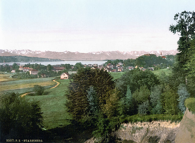
Штарнберг
Hiking in Штарнберг
Hiking in the Starnberg district, located in Bavaria, Germany, offers a beautiful blend of scenic landscapes, including lakes, forests, and picturesque villages. Here are some highlights and tips for hiking in the area:...
- Страна:
- Столица: Штарнберг
- Код автомобильного номера: WOR; STA
- Координаты: 48° 0' 36" N, 11° 16' 48" E
- GPS треки (wikiloc): [Ссылка]
- Высота над уровнем моря: 683 м m
- Площадь: 488.01 кв.км
- Население: 108887
- Веб сайт: [Ссылка]

Ландсберг-на-Лехе
- район Баварии
Hiking in Ландсберг-на-Лехе
Landsberg district, located in Bavaria, Germany, is a beautiful area that offers a variety of hiking opportunities amidst stunning natural landscapes. The region is characterized by its rolling hills, lush forests, and picturesque lakes, making it an ideal destination for outdoor enthusiasts. Here are some key points about hiking in Landsberg district:...
- Страна:
- Столица: Ландсберг-на-Лехе
- Код автомобильного номера: LL
- Координаты: 48° 1' 12" N, 10° 57' 0" E
- GPS треки (wikiloc): [Ссылка]
- Высота над уровнем моря: 636 м m
- Площадь: 804.00 кв.км
- Население: 83612
- Веб сайт: [Ссылка]

Вайльхайм-Шонгау
- район Баварии
Hiking in Вайльхайм-Шонгау
Weilheim-Schongau, located in Bavaria, Germany, is a fantastic area for hiking enthusiasts. The region is characterized by its stunning landscapes, which include rolling hills, lush forests, and the picturesque foothills of the Alps. Here are some highlights and recommendations for hiking in this beautiful region:...
- Страна:
- Столица: Вайльхайм
- Код автомобильного номера: SOG; WM
- Координаты: 47° 49' 48" N, 11° 0' 0" E
- GPS треки (wikiloc): [Ссылка]
- Высота над уровнем моря: 647 м m
- Площадь: 966.22 кв.км
- Население: 106376
- Веб сайт: [Ссылка]


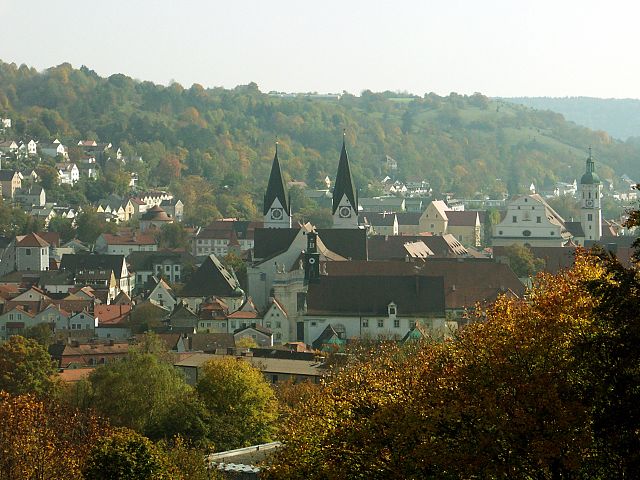
Гармиш-Партенкирхен
- район Баварии
Hiking in Гармиш-Партенкирхен
Garmisch-Partenkirchen is a beautiful district located in Bavaria, Germany, and is renowned for its stunning alpine scenery and outdoor recreational activities, making it a popular destination for hikers. Here are some key points about hiking in this picturesque area:...
- Страна:
- Столица: Гармиш-Партенкирхен
- Код автомобильного номера: GAP
- Координаты: 47° 34' 48" N, 11° 10' 12" E
- GPS треки (wikiloc): [Ссылка]
- Высота над уровнем моря: 1296 м m
- Площадь: 1012.00 кв.км
- Население: 78782
- Веб сайт: [Ссылка]

Бад-Тёльц-Вольфратсхаузен
- район Баварии
Hiking in Бад-Тёльц-Вольфратсхаузен
Bad Tölz-Wolfratshausen is a picturesque region in Bavaria, Germany, known for its stunning landscapes and excellent hiking opportunities. Nestled in the foothills of the Alps, this area offers a variety of trails that cater to different skill levels, from gentle walks suitable for families to more challenging hikes for experienced adventurers....
- Страна:
- Столица: Бад-Тёльц
- Код автомобильного номера: WOR; TÖL
- Координаты: 47° 45' 0" N, 11° 34' 48" E
- GPS треки (wikiloc): [Ссылка]
- Высота над уровнем моря: 848 м m
- Площадь: 1111.00 кв.км
- Население: 126572
- Веб сайт: [Ссылка]

Мисбах
- район Баварии
Hiking in Мисбах
Miesbach is a scenic district located in Bavaria, Germany, known for its stunning landscapes, rolling hills, and proximity to the Alps. It offers a wealth of hiking opportunities for both beginners and experienced hikers. Here are some highlights about hiking in the Miesbach district:...
- Страна:
- Столица: Мисбах
- Код автомобильного номера: MB
- Координаты: 47° 44' 24" N, 11° 48' 36" E
- GPS треки (wikiloc): [Ссылка]
- Высота над уровнем моря: 741 м m
- Площадь: 864.00 кв.км
- Население: 93630
- Веб сайт: [Ссылка]

Розенхайм
- район Баварии
Hiking in Розенхайм
Rosenheim district, located in Bavaria, Germany, offers a diverse range of hiking opportunities amidst beautiful landscapes, charming villages, and stunning natural scenery. Here are some highlights for hiking in the region:...
- Страна:
- Столица: Розенхайм
- Код автомобильного номера: WS; RO; AIB
- Координаты: 47° 55' 12" N, 12° 10' 12" E
- GPS треки (wikiloc): [Ссылка]
- Высота над уровнем моря: 512 м m
- Площадь: 1439.40 кв.км
- Население: 190104
- Веб сайт: [Ссылка]
Траунштайн
- район Баварии
Hiking in Траунштайн
Traunstein, located in Bavaria, Germany, is a beautiful area known for its picturesque landscapes, charming villages, and a variety of hiking opportunities. The region is characterized by its rolling hills, mountains, and lakes, making it ideal for outdoor enthusiasts. Here are some highlights for hiking in Traunstein:...
- Страна:
- Столица: Траунштайн
- Код автомобильного номера: TS
- Координаты: 47° 53' 24" N, 12° 34' 48" E
- GPS треки (wikiloc): [Ссылка]
- Высота над уровнем моря: 560 м m
- Площадь: 1533.92 кв.км
- Население: 145408
- Веб сайт: [Ссылка]

Берхтесгаденер-Ланд
- район Баварии
Hiking in Берхтесгаденер-Ланд
Berchtesgadener Land is a stunning region in Bavaria, Germany, known for its breathtaking landscapes, towering mountains, lush valleys, and crystal-clear lakes. It’s a hiker’s paradise with trails suitable for all levels of experience. Here are some highlights and tips for hiking in this beautiful area:...
- Страна:
- Столица: Бад-Райхенхалль
- Код автомобильного номера: BGL
- Координаты: 47° 44' 0" N, 12° 53' 0" E
- GPS треки (wikiloc): [Ссылка]
- Высота над уровнем моря: 465 м m
- Площадь: 840.00 кв.км
- Население: 90689
- Веб сайт: [Ссылка]

Альтёттинг
- район Баварии
Hiking in Альтёттинг
Altötting, located in Bavaria, Germany, is known for its historical significance as a pilgrimage site, but it also offers beautiful landscapes ideal for hiking enthusiasts. Here are some key highlights about hiking in the Altötting district:...
- Страна:
- Столица: Альтэттинг
- Код автомобильного номера: AÖ
- Координаты: 48° 15' 0" N, 12° 45' 0" E
- GPS треки (wikiloc): [Ссылка]
- Высота над уровнем моря: 436 м m
- Площадь: 569.41 кв.км
- Население: 94216
- Веб сайт: [Ссылка]

Мюльдорф-на-Инне
- район Баварии
Hiking in Мюльдорф-на-Инне
Mühldorf District, located in Bavaria, Germany, offers a range of hiking opportunities that cater to different skill levels and preferences. The area features scenic landscapes, including rolling hills, forests, and rivers, making it an attractive destination for nature lovers and outdoor enthusiasts....
- Страна:
- Столица: Мюльдорф-на-Инне
- Код автомобильного номера: MÜ
- Координаты: 48° 15' 0" N, 12° 25' 12" E
- GPS треки (wikiloc): [Ссылка]
- Высота над уровнем моря: 447 м m
- Площадь: 805.32 кв.км
- Население: 92882

Эрдинг
- район Баварии
Hiking in Эрдинг
Erding, located in Bavaria, Germany, offers a variety of hiking opportunities for enthusiasts of all skill levels. This district is characterized by its beautiful landscapes, rolling hills, and picturesque villages, making it a wonderful destination for outdoor activities....
- Страна:
- Код автомобильного номера: ED
- Координаты: 48° 19' 48" N, 11° 55' 12" E
- GPS треки (wikiloc): [Ссылка]
- Высота над уровнем моря: 480 м m
- Площадь: 870.44 кв.км
- Население: 89190
- Веб сайт: [Ссылка]

Эберсберг
- район Баварии
Hiking in Эберсберг
Ebersberg District, located in Bavaria, Germany, is a fantastic destination for hiking enthusiasts. This region offers a mix of lush forests, rolling hills, picturesque landscapes, and scenic views, making it perfect for both casual walkers and more experienced hikers....
- Страна:
- Столица: Эберсберг
- Код автомобильного номера: EBE
- Координаты: 48° 4' 48" N, 11° 55' 12" E
- GPS треки (wikiloc): [Ссылка]
- Высота над уровнем моря: 601 м m
- Площадь: 549.30 кв.км
- Население: 96283
- Веб сайт: [Ссылка]

Мюнхен
- район Баварии
Hiking in Мюнхен
Hiking in and around Munich, the capital of Bavaria, offers a wonderful blend of urban landscapes and stunning natural scenery. While Munich itself is a vibrant city with parks and green spaces, many hiking opportunities are just a short distance away in the surrounding region....
- Страна:
- Столица: Мюнхен
- Телефонный код: 089
- Код автомобильного номера: WOR; M; AIB
- Координаты: 48° 0' 0" N, 11° 40' 12" E
- GPS треки (wikiloc): [Ссылка]
- Высота над уровнем моря: 513 м m
- Площадь: 52020.58 кв.км
- Население: 343405
- Веб сайт: [Ссылка]
Мюнхен
- город в Германии, столица Баварии
Hiking in Мюнхен
Hiking in Munich offers a fantastic blend of urban and natural experiences. Munich is the capital of Bavaria, situated close to the Alps, which makes it an excellent base for various hikes. Here’s an overview of hiking in and around Munich:...
- Страна:
- Почтовый код: 81825; 81735; 81730; 81737; 81379; 81377; 80805; 80802; 81929; 80331
- Телефонный код: 089
- Код автомобильного номера: M
- Координаты: 48° 8' 14" N, 11° 34' 32" E
- GPS треки (wikiloc): [Ссылка]
- Высота над уровнем моря: 519 м m
- Площадь: 310.71 кв.км
- Население: 1456039
- Веб сайт: [Ссылка]

Ингольштадт
- город в Баварии, Германия
Hiking in Ингольштадт
Hiking in and around Ingolstadt, a city located in Bavaria, Germany, offers a variety of scenic routes and natural landscapes to explore. While Ingolstadt itself is more urban, it’s conveniently situated near several natural attractions and parks. Here are some key points to consider when hiking in this region:...
- Страна:
- Почтовый код: 85055; 85053; 85051; 85057; 85049
- Телефонный код: 08459; 08458; 08450; 0841; 08424
- Код автомобильного номера: IN
- Координаты: 48° 45' 49" N, 11° 25' 34" E
- GPS треки (wikiloc): [Ссылка]
- Высота над уровнем моря: 368 м m
- Площадь: 133.35 кв.км
- Население: 137072
- Веб сайт: [Ссылка]
Розенхайм
- город в Германии
Hiking in Розенхайм
Rosenheim, located in Bavaria, Germany, is a picturesque town that serves as a gateway to some stunning hiking opportunities in the surrounding Alps and foothills. Here are some highlights and tips for hiking in and around Rosenheim:...
- Страна:
- Почтовый код: 83026; 83024; 83022
- Телефонный код: 08031
- Код автомобильного номера: RO
- Координаты: 47° 51' 22" N, 12° 7' 44" E
- GPS треки (wikiloc): [Ссылка]
- Высота над уровнем моря: 447 м m
- Площадь: 37.52 кв.км
- Население: 60464
- Веб сайт: [Ссылка]
Граничит с регионами:


Средняя Франкония
- административный округ Баварии
Hiking in Средняя Франкония
Middle Franconia, located in Bavaria, Germany, is a picturesque region known for its diverse landscapes, charming villages, and rich cultural heritage. It offers a variety of hiking opportunities suitable for all levels of experience. Here are some highlights regarding hiking in this area:...
- Страна:
- Столица: Ансбах
- Координаты: 49° 18' 0" N, 10° 35' 0" E
- GPS треки (wikiloc): [Ссылка]
- Высота над уровнем моря: 401 м m
- Площадь: 7245.70 кв.км
- Население: 1750059
- Веб сайт: [Ссылка]


Верхний Пфальц
- административный округ Баварии
Hiking in Верхний Пфальц
The Upper Palatinate (Oberpfalz) region in Bavaria, Germany, is known for its scenic landscapes, picturesque villages, and rich cultural heritage, making it an excellent destination for hiking enthusiasts. Here are some highlights and tips for hiking in the Upper Palatinate:...
- Страна:
- Столица: Регенсбург
- Координаты: 49° 18' 0" N, 12° 12' 0" E
- GPS треки (wikiloc): [Ссылка]
- Высота над уровнем моря: 628 м m
- Площадь: 9691.03 кв.км
- Население: 1098378
- Веб сайт: [Ссылка]

Швабия
- административный округ в земле Бавария, Германия
Hiking in Швабия
Swabia, a picturesque region in Bavaria, Germany, offers a variety of hiking opportunities ranging from gentle walks to challenging trails. Known for its diverse landscapes, Swabia features lush forests, rolling hills, scenic lakes, and impressive mountain ranges, making it a fantastic destination for outdoor enthusiasts....
- Страна:
- Столица: Аугсбург
- Координаты: 48° 30' 0" N, 10° 30' 0" E
- GPS треки (wikiloc): [Ссылка]
- Высота над уровнем моря: 560 м m
- Площадь: 9992.03 кв.км
- Население: 1857991
- Веб сайт: [Ссылка]


Нижняя Бавария
- административный округ в Баварии
Hiking in Нижняя Бавария
Lower Bavaria, located in the southeastern part of Germany, is a fantastic region for hiking enthusiasts, offering a diverse landscape that includes rolling hills, dense forests, rivers, and picturesque villages. Here are some highlights and tips for hiking in Lower Bavaria:...
- Страна:
- Столица: Ландсхут
- Координаты: 48° 41' 25" N, 12° 44' 52" E
- GPS треки (wikiloc): [Ссылка]
- Высота над уровнем моря: 320 м m
- Площадь: 10329.87 кв.км
- Население: 1181472
- Веб сайт: [Ссылка]