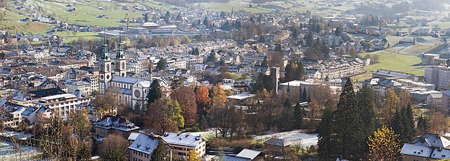
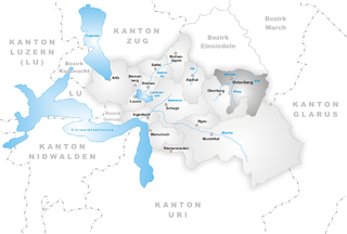
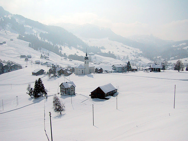
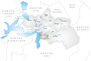
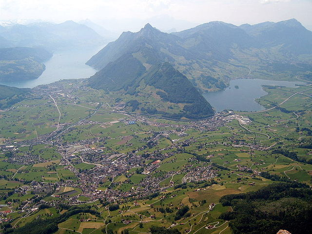
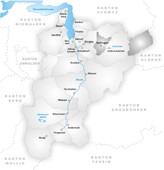
Муотаталь (Muotathal, Muotathal)

- Kоммуна в Швейцарии
 Hiking in Муотаталь
Muotathal, located in the heart of Switzerland, offers stunning landscapes and diverse hiking opportunities, making it a fantastic destination for both novice and experienced hikers. Here are some highlights and tips for hiking in this beautiful region:
Scenery and Terrain
- Dramatic Landscapes: Muotathal is surrounded by impressive mountains, lush green valleys, and peaceful alpine meadows. The region is characterized by its rugged terrain and dramatic rock formations, which provide breathtaking views and a variety of hiking experiences.
- Access to Nature: The area is rich in biodiversity, and hikers often spot various flora and fauna along the trails.
Hiking Trails
- Variety of Trails: There are several marked hiking trails ranging from easy walks suitable for families to more challenging hikes for experienced adventurers. Trails can lead you through picturesque hamlets, up to mountain peaks, or around serene lakes.
- Notable Routes:
- Küsnachter Tälli: A scenic route known for its striking natural beauty; suitable for moderate hikers.
- Grosse Mythen: For a more challenging hike, this trail leads to the summit of the Grosse Mythen mountain, offering panoramic views of the surrounding region.
- Seasonal Variations: Different trails may be accessible depending on the season, so it's advisable to check trail conditions before setting out.
Planning Your Hike
- Trail Maps: It's recommended to have a detailed trail map or a GPS device, as some trails may not be well-marked.
- Weather Conditions: The weather can change rapidly in the mountains, so it’s crucial to check the forecast and be prepared for all conditions.
- Equipment: Good hiking boots, layering clothing, and essential gear (such as food, water, first-aid kit, and extra layers) are necessary to ensure a safe and enjoyable hike.
Local Culture and Amenities
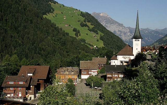
- Cultural Sites: Along your hike, you may encounter traditional Swiss chalets and even have the opportunity to taste local dishes in mountain huts or restaurants.
- Accessible Amenities: Muotathal has various facilities, including accommodations and eateries, making it easier to plan your trip.
Safety Tips
- Inform Someone: Always let someone know your hiking plans and estimated return time.
- Follow the Rules: Stay on marked trails to protect the environment and ensure your safety.
Overall, hiking in Muotathal is a rewarding experience that showcases the natural beauty and tranquility of the Swiss Alps. Whether looking for a leisurely stroll or an arduous trek, this region has something to offer everyone.
- Страна:

- Почтовый код: 6436
- Телефонный код: 041
- Код автомобильного номера: SZ
- Координаты: 46° 58' 28" N, 8° 45' 28" E


- GPS треки (wikiloc): [Ссылка]
- Высота над уровнем моря: 610 м m
- Площадь: 172.15 кв.км
- Население: 3515
- Веб сайт: http://www.muotathal.ch
- Википедия русская: wiki(ru)
- Википедия английская: wiki(en)
- Википедия национальная: wiki(de)
- Хранилище Wikidata: Wikidata: Q66069
- Катеория в википедии: [Ссылка]
- код Freebase: [/m/0fw51d]
- код GeoNames: Альт: [7286596]
- код VIAF: Альт: [167589845]
- ID отношения в OpenStreetMap: [1683092]
- место в MusicBrainz: [e31b9e04-28ef-4984-9281-93796231a516]
- идентификатор HDS: [731]
- код швейцарского муниципалитета: [1367]
Граничит с регионами:

Гларус
Hiking in Гларус
Hiking in Glarus offers a stunning experience with a mix of picturesque landscapes, diverse trails, and a wealth of natural beauty. Located in the heart of Switzerland, Glarus is surrounded by impressive mountains, lush valleys, and clear lakes, making it a perfect destination for outdoor enthusiasts....
- Страна:
- Почтовый код: 8750
- Телефонный код: 055
- Код автомобильного номера: GL
- Координаты: 47° 1' 59" N, 9° 3' 59" E
- GPS треки (wikiloc): [Ссылка]
- Высота над уровнем моря: 474 м m
- Площадь: 103.6 кв.км
- Население: 12515
- Веб сайт: [Ссылка]

Унтериберг
- коммуна в Швейцарии
Hiking in Унтериберг
Unteriberg, located in the beautiful region of Switzerland, offers a variety of hiking opportunities that cater to different skill levels and preferences. Nestled in the Swiss Alps, it provides stunning views, lush landscapes, and an enjoyable outdoor experience....
- Страна:
- Почтовый код: 8842
- Телефонный код: 055
- Код автомобильного номера: SZ
- Координаты: 47° 2' 53" N, 8° 49' 53" E
- GPS треки (wikiloc): [Ссылка]
- Высота над уровнем моря: 1469 м m
- Площадь: 46.7 кв.км
- Население: 2413
- Веб сайт: [Ссылка]


Ильгау
- коммуна в Швейцарии
Hiking in Ильгау
Illgau is a picturesque village located in the canton of Schwyz in Switzerland. It's nestled on a sun-drenched terrace above the Muotatal valley, providing stunning views of the surrounding mountains and landscapes. Hiking in Illgau offers a varied experience, suitable for a range of skill levels, from easy family-friendly walks to more challenging mountain trails....
- Страна:
- Почтовый код: 6434
- Телефонный код: 041
- Код автомобильного номера: SZ
- Координаты: 46° 59' 48" N, 8° 44' 24" E
- GPS треки (wikiloc): [Ссылка]
- Высота над уровнем моря: 1128 м m
- Площадь: 10.9 кв.км
- Население: 797
- Веб сайт: [Ссылка]


Унтершехен
- коммуна в Швейцарии
Hiking in Унтершехен
Unterschächen is a picturesque village located in the heart of the Swiss Alps, specifically in the canton of Uri. It's a great destination for hiking enthusiasts due to its stunning mountain scenery and a variety of trails suitable for different skill levels....
- Страна:
- Почтовый код: 6465
- Телефонный код: 041
- Код автомобильного номера: UR
- Координаты: 46° 51' 30" N, 8° 47' 37" E
- GPS треки (wikiloc): [Ссылка]
- Высота над уровнем моря: 1552 м m
- Площадь: 80.33 кв.км
- Население: 714
- Веб сайт: [Ссылка]


Иннерталь
- коммуна в Швейцарии
Hiking in Иннерталь
Innerthal is a picturesque valley located in the Swiss region of the Canton of Schwyz, known for its stunning landscapes, rich flora and fauna, and a variety of hiking trails that cater to different skill levels. Here are some details to consider when hiking in Innerthal:...
- Страна:
- Почтовый код: 8858
- Телефонный код: 055
- Код автомобильного номера: SZ
- Координаты: 47° 6' 18" N, 8° 55' 7" E
- GPS треки (wikiloc): [Ссылка]
- Высота над уровнем моря: 915 м m
- Площадь: 50.22 кв.км
- Население: 177
- Веб сайт: [Ссылка]


Рименстальден
- коммуна в Швейцарии
Hiking in Рименстальден
Riemenstalden is a picturesque area located in Switzerland, known for its stunning landscapes and a range of hiking opportunities. Here’s what you should know if you're considering hiking in Riemenstalden:...
- Страна:
- Почтовый код: 6452
- Телефонный код: 041
- Код автомобильного номера: SZ
- Координаты: 46° 56' 50" N, 8° 39' 55" E
- GPS треки (wikiloc): [Ссылка]
- Высота над уровнем моря: 1030 м m
- Площадь: 11.20 кв.км
- Население: 88
- Веб сайт: [Ссылка]

Обериберг
- коммуна в Швейцарии
Hiking in Обериберг
Oberiberg is a beautiful village located in Switzerland, nestled in the Ybrig region of central Switzerland. It's surrounded by stunning mountain landscapes, making it a fantastic destination for hiking enthusiasts of all levels. Here are some highlights and tips for hiking in Oberiberg:...
- Страна:
- Почтовый код: 8843
- Телефонный код: 055
- Код автомобильного номера: SZ
- Координаты: 47° 1' 49" N, 8° 46' 55" E
- GPS треки (wikiloc): [Ссылка]
- Высота над уровнем моря: 1283 м m
- Площадь: 32.90 кв.км
- Население: 888
- Веб сайт: [Ссылка]

Моршах
- коммуна в Швейцарии
Hiking in Моршах
Morschach, a charming village located in Switzerland, is a great destination for hiking enthusiasts. Nestled in the scenic landscape of central Switzerland, it offers stunning views of Lake Lucerne and the surrounding mountains. Here are some highlights and tips for hiking in Morschach:...
- Страна:
- Почтовый код: 6443
- Телефонный код: 041
- Код автомобильного номера: SZ
- Координаты: 46° 58' 54" N, 8° 37' 11" E
- GPS треки (wikiloc): [Ссылка]
- Высота над уровнем моря: 1682 м m
- Площадь: 23.4 кв.км
- Население: 1103
- Веб сайт: [Ссылка]

Швиц
- город в Швейцарии, столица кантона Швиц
Hiking in Швиц
Hiking in Schwyz, located in central Switzerland, offers stunning landscapes, rich history, and a variety of trails catering to different skill levels. Here are some highlights and tips for hiking in this beautiful region:...
- Страна:
- Почтовый код: 6430
- Телефонный код: 041
- Код автомобильного номера: SZ
- Координаты: 47° 1' 14" N, 8° 39' 30" E
- GPS треки (wikiloc): [Ссылка]
- Высота над уровнем моря: 852 м m
- Площадь: 53.28 кв.км
- Население: 15000
- Веб сайт: [Ссылка]


Бюрглен
- коммуна в Швейцарии, в кантоне Ури
Hiking in Бюрглен
Bürglen is a picturesque village located in the Uri region of Switzerland, surrounded by stunning alpine landscapes and rich cultural history. The area is perfect for hiking enthusiasts, offering a variety of trails that cater to different skill levels....
- Страна:
- Почтовый код: 6463
- Телефонный код: 041
- Код автомобильного номера: UR
- Координаты: 46° 52' 30" N, 8° 39' 46" E
- GPS треки (wikiloc): [Ссылка]
- Высота над уровнем моря: 525 м m
- Площадь: 53.14 кв.км
- Население: 3982
- Веб сайт: [Ссылка]
Шпиринген
- коммуна в Швейцарии
Hiking in Шпиринген
Spiringen is a picturesque village located in the Canton of Uri, Switzerland, and is a great destination for hiking enthusiasts. Nestled in the Urner Valley, it offers stunning views of the surrounding mountains and has access to a variety of hiking trails suitable for different skill levels....
- Страна:
- Почтовый код: 8751; 6464
- Телефонный код: 041
- Код автомобильного номера: UR
- Координаты: 46° 52' 42" N, 8° 50' 37" E
- GPS треки (wikiloc): [Ссылка]
- Высота над уровнем моря: 2267 м m
- Площадь: 64.73 кв.км
- Население: 843
- Веб сайт: [Ссылка]

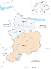
Glarus Süd
Hiking in Glarus Süd
Glarus Süd, located in the canton of Glarus in Switzerland, is a fantastic destination for hiking enthusiasts. This region boasts stunning landscapes, ranging from lush valleys to rugged mountain terrains. Here are some key points about hiking in Glarus Süd:...
- Страна:
- Почтовый код: 8756, 8762, 8765, 8766, 8767, 8772, 8773, 8774, 8775, 8777, 8782, 8783, 8784
- Телефонный код: 055
- Код автомобильного номера: GL
- Координаты: 46° 59' 40" N, 9° 4' 27" E
- GPS треки (wikiloc): [Ссылка]
- Высота над уровнем моря: 521 м m
- Площадь: 430.2 кв.км
- Население: 9581
- Веб сайт: [Ссылка]