Начбах-Лойперсбах (Natschbach-Loipersbach, Natschbach-Loipersbach)
 Hiking in Начбах-Лойперсбах
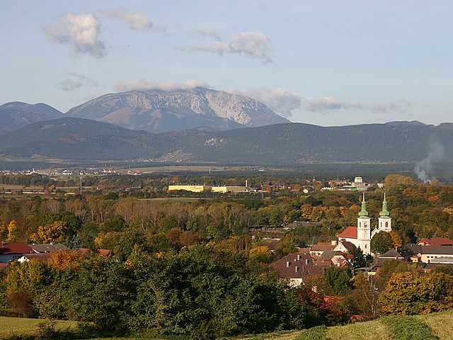
Natschbach-Loipersbach, located in Lower Austria, offers a scenic environment for hiking enthusiasts. The region is characterized by its rolling hills, lush forests, and picturesque landscapes, making it an ideal location for both casual walkers and more experienced hikers.
Hiking Trails:
-
Local Trails: The area features a variety of well-marked hiking trails that cater to different skill levels. You can find routes that lead through forests, along streams, and up to viewpoints with stunning panoramas of the surrounding countryside.
-
Nature Trails: Look for designated nature trails that not only provide a great hiking experience but also educate about the local flora and fauna. These trails are often suitable for families and can be enjoyed at a leisurely pace.
-
Themed Trails: Some trails may have specific themes, such as historical or cultural significance, which allow hikers to learn about the region's heritage as they hike.
Recommendations:
-
Proper Gear: Ensure you wear appropriate hiking footwear and clothing for comfort. The terrain can vary, so consider bringing trekking poles if you're hiking on more uneven paths.
-
Timing: Spring and autumn are particularly beautiful times to hike in this region, as the weather is mild and the scenery is vibrant. Summer may be hotter, and winter could bring snow, depending on the trails you choose.
-
Stay Hydrated: Always carry enough water, especially for longer hikes. Check if there are any supply points or places to refill along the trail.
-
Wildlife: Be aware of local wildlife and respect their habitats. It's important to follow local regulations regarding interactions with animals and nature.
Local Attractions:
After your hike, consider exploring nearby towns or cultural sites, as this area is rich in history and local traditions. You can also enjoy local cuisine in nearby restaurants to complete your outdoor experience.
Always check local resources for trail maps, conditions, and any potential restrictions or weather advisories before heading out. Enjoy your hiking adventure in Natschbach-Loipersbach!
- Страна:

- Почтовый код: 2620
- Телефонный код: 0 26 35
- Код автомобильного номера: NK
- Координаты: 47° 42' 0" N, 16° 6' 0" E


- GPS треки (wikiloc): [Ссылка]
- Высота над уровнем моря: 366 м m
- Площадь: 10.62 кв.км
- Население: 1702
- Веб сайт: http://www.natschbach-loipersbach.gv.at/
- Википедия русская: wiki(ru)
- Википедия английская: wiki(en)
- Википедия национальная: wiki(de)
- Хранилище Wikidata: Wikidata: Q338255
- Катеория в википедии: [Ссылка]
- код Freebase: [/m/02qzlfj]
- код GeoNames: Альт: [7871865]
- код VIAF: Альт: [154606255]
- код австрийского муниципалитета: [31817]
Граничит с регионами:
Брайтенау
Hiking in Брайтенау
Breitenau, located in Lower Austria, offers picturesque hiking opportunities amidst stunning natural landscapes. The region is characterized by rolling hills, lush forests, and beautiful meadows. Here are some highlights of hiking in Breitenau:...
- Страна:
- Почтовый код: 2624
- Телефонный код: 02635
- Код автомобильного номера: NK
- Координаты: 47° 44' 0" N, 16° 9' 0" E
- GPS треки (wikiloc): [Ссылка]
- Высота над уровнем моря: 343 м m
- Площадь: 9.63 кв.км
- Население: 1576
- Веб сайт: [Ссылка]

Нойнкирхен
- муниципалитет в Австрии, Нижняя Австрия, Нойнкирхен
Hiking in Нойнкирхен
Neunkirchen, a charming town nestled in Lower Austria, offers various hiking opportunities that cater to different skill levels and interests. Here are some key highlights you can expect when hiking in and around Neunkirchen:...
- Страна:
- Почтовый код: 2620
- Телефонный код: 02635
- Код автомобильного номера: NK
- Координаты: 47° 43' 37" N, 16° 4' 54" E
- GPS треки (wikiloc): [Ссылка]
- Высота над уровнем моря: 371 м m
- Площадь: 20.28 кв.км
- Население: 12879
- Веб сайт: [Ссылка]

Зеебенштайн
Hiking in Зеебенштайн
Seebenstein, located in Lower Austria, is a charming destination for hiking enthusiasts. It offers beautiful landscapes, rich flora and fauna, and a variety of trails suitable for different skill levels. Here are some key points to consider when planning a hike in Seebenstein:...
- Страна:
- Телефонный код: 02627
- Код автомобильного номера: NK
- Координаты: 47° 42' 7" N, 16° 8' 41" E
- GPS треки (wikiloc): [Ссылка]
- Высота над уровнем моря: 348 м m
- Площадь: 9.09 кв.км
- Население: 1401
- Веб сайт: [Ссылка]
Шайблингирхен-Тернберг
Hiking in Шайблингирхен-Тернберг
Scheiblingkirchen-Thernberg, located in Lower Austria, offers a variety of hiking opportunities for outdoor enthusiasts. The region is characterized by its picturesque landscapes, rolling hills, and diverse natural environments. Here are some highlights for hiking in this area:...
- Страна:
- Телефонный код: 02629
- Код автомобильного номера: NK
- Координаты: 47° 39' 0" N, 16° 8' 0" E
- GPS треки (wikiloc): [Ссылка]
- Высота над уровнем моря: 373 м m
- Площадь: 37.83 кв.км
- Население: 1864
- Веб сайт: [Ссылка]
Шварцау-ам-Штайнфельде
Hiking in Шварцау-ам-Штайнфельде
Schwarzau am Steinfeld is a picturesque village located in the Lower Austria region of Austria, surrounded by stunning natural landscapes that are perfect for hiking enthusiasts. The area features a variety of trails that cater to different skill levels, making it suitable for both beginners and experienced hikers....
- Страна:
- Телефонный код: 02627
- Код автомобильного номера: NK
- Координаты: 47° 43' 0" N, 16° 10' 0" E
- GPS треки (wikiloc): [Ссылка]
- Высота над уровнем моря: 329 м m
- Площадь: 9.75 кв.км
- Население: 1924
- Веб сайт: [Ссылка]
Вартманнштеттен
Hiking in Вартманнштеттен
Wartmannstetten is a small, picturesque village in Austria, located in the region of Lower Austria. It is surrounded by beautiful natural landscapes, making it a great destination for hiking enthusiasts. Here are some aspects to consider when hiking in Wartmannstetten:...
- Страна:
- Почтовый код: 2620
- Телефонный код: 02635
- Код автомобильного номера: NK
- Координаты: 47° 41' 0" N, 16° 4' 0" E
- GPS треки (wikiloc): [Ссылка]
- Высота над уровнем моря: 419 м m
- Площадь: 21.41 кв.км
- Население: 1605
- Веб сайт: [Ссылка]